
SORRY, THIS PROPERTY HAS BEEN SOLD! – This was our “Featured Property” and it sold within just a few minutes of the Featured Property Email being sent out (which is common for “Top Shelf” tracts). – We may have an additional tract on the Niangua River that could be available within the next 1-2 weeks. It is similar in size and is located within about half a mile of this tract. Please contact our office with any questions.
Riverside At The Niangua is truly one of the most exciting and unique projects you will ever see. This small, private area contains a very limited number of tracts with TRUE frontage on the wildly popular Niangua River in the beautiful Missouri Ozarks.
Not only is the Niangua River one of the most popular and beautiful rivers in the state, but this particular section of the Niangua is well known to be a proven area for some of the most amazing fishing you can find ANYWHERE. Trout (rainbow trout AND brown trout) and bass fishing in this section of the river is popular year after year. This section is also home to a number of small resorts and outfitters as this particular section is EXCELLENT for canoeing, kayaking, swimming and floating.
Bennett Springs State Park is just a few miles up the river from these tracts and the Park is regularly stocked with brown and rainbow trout, which are raised in the waters of the river. People come from all over the country to fish, float, kayak and canoe right here!
By the way, the deer and turkey hunting in this area are excellent as well.
Properties with TRUE frontage on a named river are rare. Properties with TRUE frontage on the Niangua River, just down from Bennett Springs State Park are more than rare. There is only a 12 mile section of “White Ribbon Trout Fishing” and this property has 194 feet of DIRECT RIVER FRONTAGE in the White Ribbon Area.
PLEASE NOTE: This property has been leased out for several years and is now available for sale. Most of the videos/photos in this listing were taken a few years ago, before the property was leased out. The trees may be a little larger and the grass/brush is likely to be higher on the site at the south end of the property (by the river). Please keep in mind that you will want a four wheel drive truck or suv to drive to the south part of this property as the last section of easement road can be rough (depending on the weather).
In the video below, we explore the property with our drone:

Owner Financed 10 acres on TROUT RIVER in MO – InstantAcres.com – ID#RN18 – Rare DIRECT frontage!
In the video below, we check out the river frontage on the property:
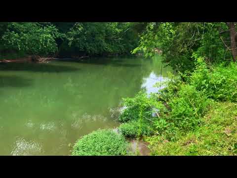
Owner Financed Trout Fishing 10 Acres! – InstantAcres.com – ID#RN18
As we mentioned earlier, this particular portion of the Niangua River is what is referred to as a “White Ribbon Section” for trout fishing! The “White Ribbon” designation means that this section is managed specifically for catching rainbow and brown trout. There is only a 12 mile section along the entire Niangua River that is designated as a “White Ribbon Section” for trout fishing. This means more fishing and fun for you and your family!
The large Barclay Conservation Area is DIRECTLY across the river from the tract! Not only does this give you 400+ acres of additional land for hunting, recreation, fishing and exploring BUT it also ensures that no one will build across from your private river front tract!
By the way, the river is also well known for bass fishing as well as several other species. So if trout fishing isn’t your thing you can go after the bass, catfish or sunfish. Maybe fishing isn’t your thing at all. No worries! This section of the river is great for swimming, floating, exploring, kayaking or just generally hanging out. How about a river-side BBQ or campfire?
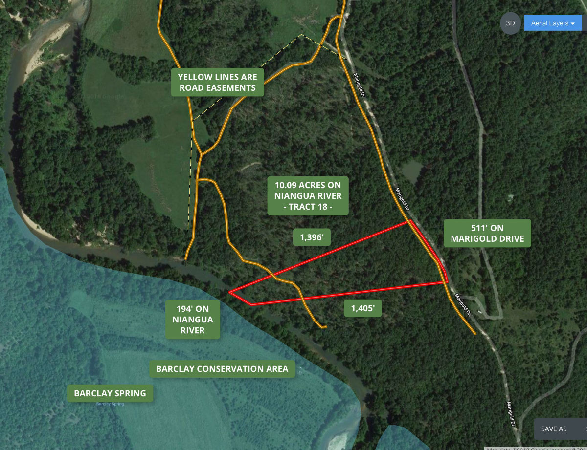
Tract 18 at Riverside At The Niangua is fully surveyed and is 10.09 acres in size.
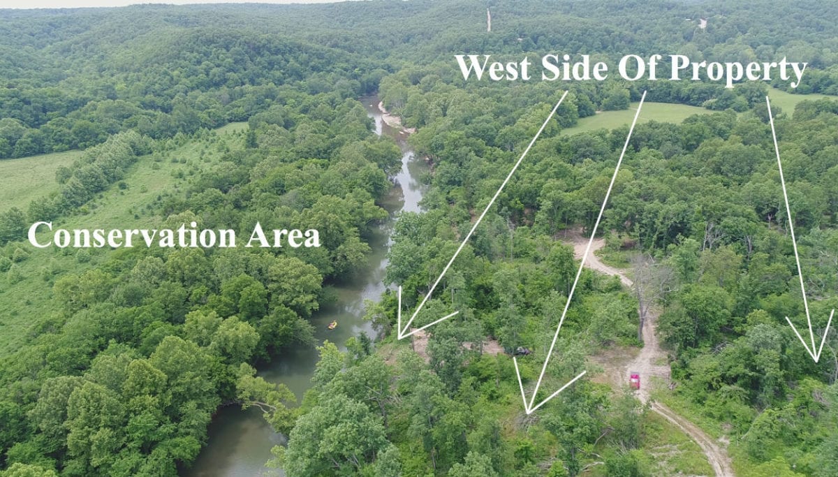
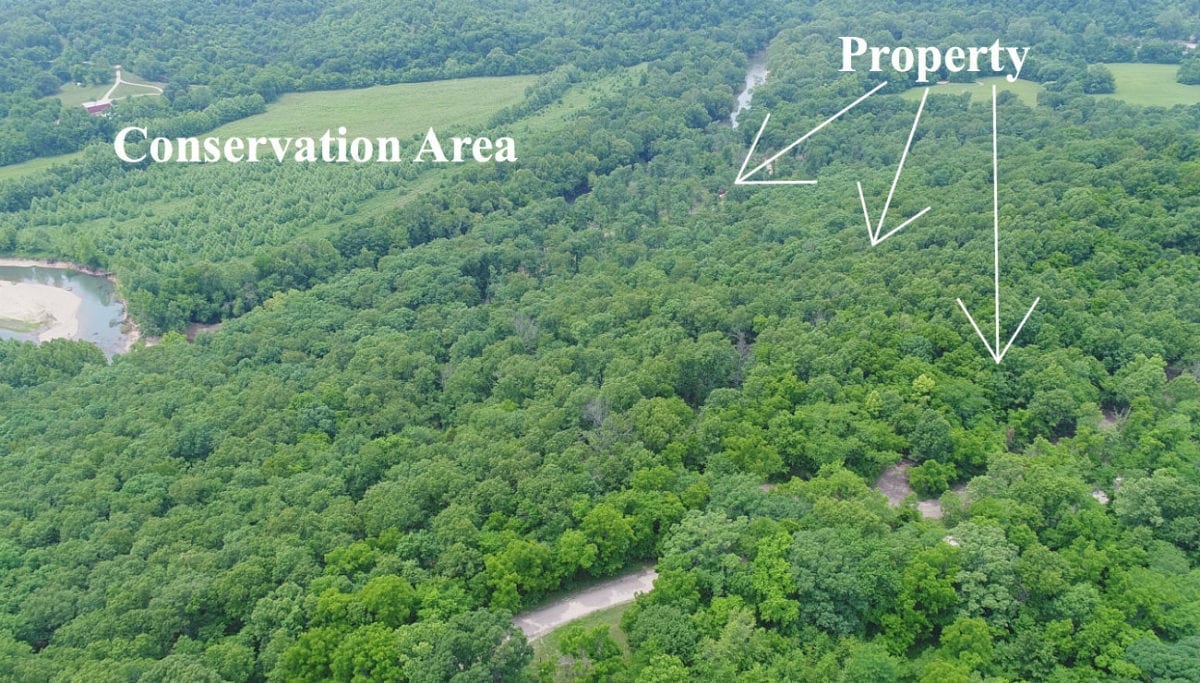
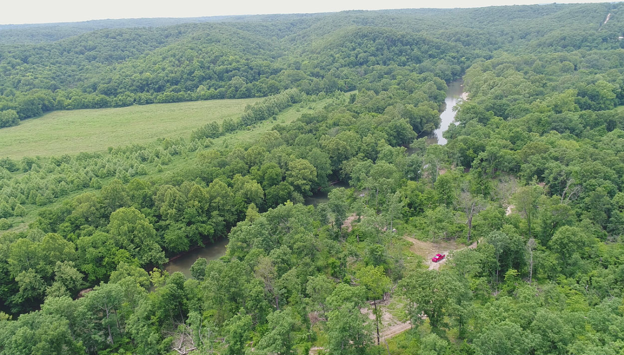
In the aerial photo above we are looking northerly over the west side of the property. The Barclay Conservation area is directly across the river from the property. The red truck is parked on the easement road which takes you to the south side of the property.
This 10.09 acre tract features 194 FEET OF DIRECT FRONTAGE on the Niangua River along its entire west side. Amazing frontage giving you plenty of space for shoring your canoes or kayaks, fishing for trout, bass and other fish or setting up a few tents or beach chairs for the family and friends.
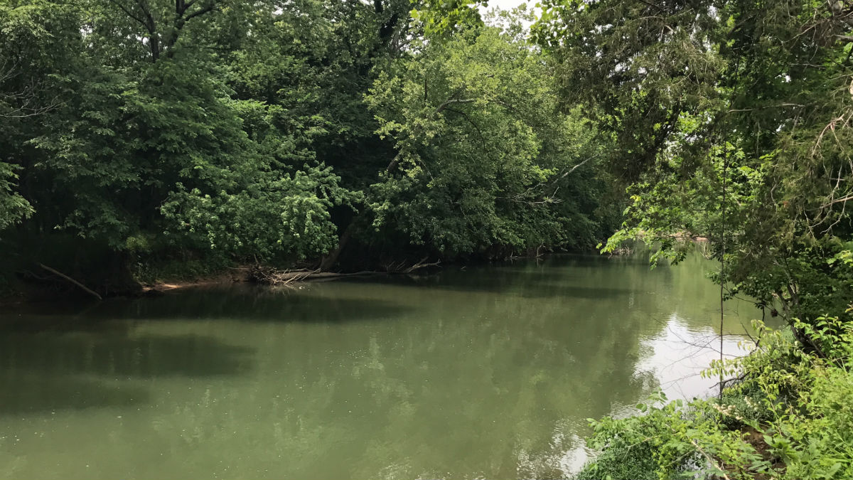
In the photo above we are looking down-river from the property. You can see the Barclay Conservation Area which is directly across the river from the property.
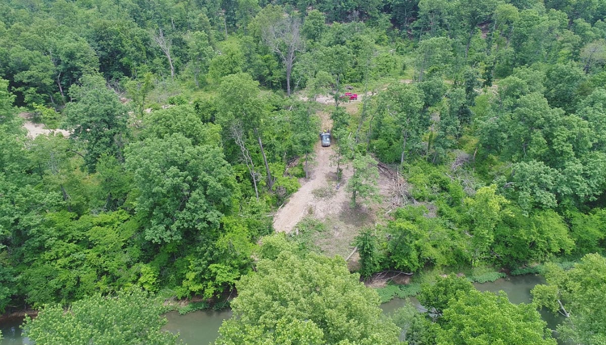
In the aerial photo above we are over the Barclay Conservation Area looking easterly at the property. This photo was taken just after a site had been cleared next to the river on the property (which is why you see so much “dirt” in the photo). By now, this site is likely to have grown up with grass/weeds/brush and will need to me mowed with a brushhog or heavy-duty weedwacker.
TERMS OF SALE
The full sales price for this 10 acre riverfront tract is $169,500 and we offer INSTANT owner financing with a $2,500 down payment.
With your $2,500 down payment you will automatically get the reduced annual interest rate of 6 3/4% and the monthly payments will be $1,502.80.
With a $5,000 down payment the interest rate drops to 5 3/4% and the payment drops to $1,391.03 a month. These payments are all based on about a 15 year payment schedule. Property taxes & road maintenance fees total about $300 per year and this is already included in the monthly payment amount. There are NO prepayment penalties and NO hidden fees.
PLEASE NOTE that you have a TWELVE MONTHS to ADD to your down payment in order to reduce your interest rate and payment amount! We want to give ALL of our buyers the opportunity to achieve the lowest interest rate and payment amount possible!
ALSO, if you pay off your property (your loan to us) at any time within the next 5 years you will get a 10% DISCOUNT off of the purchase price of the property! On this property that would save you $16,950 for an early payoff!
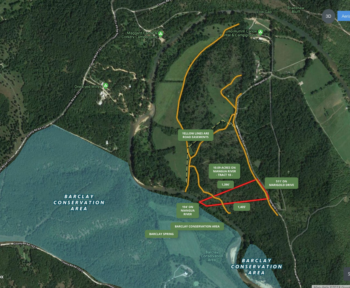
The aerial map above shows how the property is situated. This property is fully surveyed and it is 10.09 acres in size. It borders Marigold Drive along its east side (for about 511 feet) and it borders the Niangua River along its west side for about 194 feet. The yellow lines on the map above are road easements which are helpful in accessing various parts of the property. The property is the highest on the east side by Marigold Drive and it slopes down as you move westerly, toward the river.
In addition to the direct road frontage on Marigold Drive, there are other road easements which give you access to different parts of the property (shown in yellow on the maps).
The aerial photo above shows the property as well as road easements. The yellow line next to Marigold Drive is a small easement road which crosses over the east side of the property, potentially giving you access to the east side without having to install a driveway off of Marigold Drive.
Although portions of this property were logged several years ago there is still mature timber including white oak, red oak, hickory and cedar. Please note that the timber may not be cut or sold until the property has been paid for in full (exceptions can be made for creating trails/building sites).
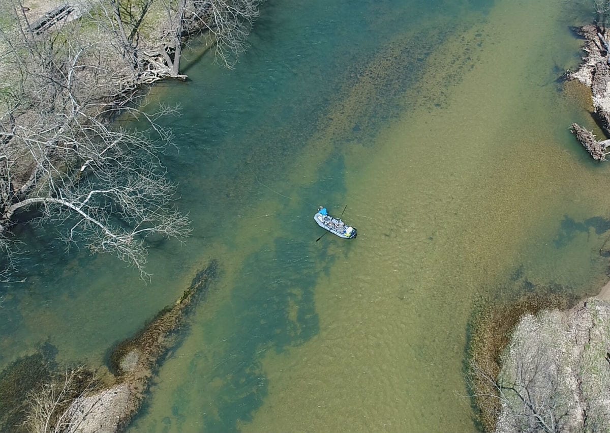
The gentleman in the aerial photo above was fishing for trout just a few hundred feet from the property.
There are numerous areas on the property that could be suitable for building, camping or hunting.
Check out the interactive map below!
Please refer to our interactive map above for additional property views and information. Please note that the boundary lines and measurements are approximate. This interactive map is fairly new for us and if you have a chance we would love to have your feedback on it. Is it awesome? Is it great? Is it confusing? We would like to know!
Also, please note that on the interactive map it seems to work best if you click the “View Full Screen” option. Once you are in the “Full Screen” option you can select “Topo” to see a topographic map which does a good job of showing how the property is situated.
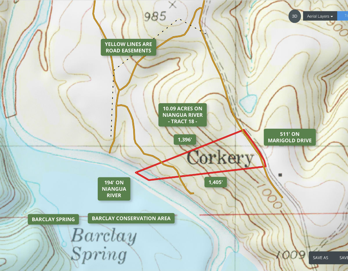
The topo map above shows how the land “lays”. Each line indicates an elevation change of 20 feet so when the lines are close the land is sloped and when the lines are far apart the land is flat (or nearly flat). The property is the highest toward the east side (by Marigold Drive) and it slopes down as you head west toward the river. You will find a large flat area on the east side of the property. Although you could potentially clear/install a road or trail going from the east side all the way to the west end, it is probably much easier to use the road easements (yellow lines on the topo map) which give you access to different parts of the property. Marigold Drive is a public road but the road easements themselves are private road easements for property owners only, not for the public.
The word “Corkery” on the topo map is a reference to the old town of Corkery which apparently used to be right in the this area in the early 1900’s.
We have been told the the trout fishing in this specific section of the river is excellent because the Barclay Spring empties into the river just a few hundred feet past the property. You can see the Barclay Spring toward the bottom of the topo map above. The trout love the cold water from the Barclay Spring so they tend to hang out near the property. So……this particular property happens to be in possibly the best area of the best section of the best trout fishing river in the Ozarks. Wow. Even if you don’t trout fish, that is pretty neat!
In the aerial photo above we are over Marigold Drive looking westerly over the property toward the river. Across the river is the Barclay Conservation Area.
This property is private and secluded with an amazing amount of wildlife. On the property you can expect to see whitetail deer as well as wild turkey. This area has a proven track record for both deer and turkey hunting. In the river you can expect to find trout, bass and many other types of fish. Although this tract is very private it is only about 20 miles from Lebanon, Missouri which is the largest regional city in the area.
In the video below we take a look at the tract and its surrounding area:

Intro Video – Owner Financed 10+ Acres on TROUT RIVER – InstantAcres.com – ID#RN18
The video below shows the property from the ground. This is a really long video but it does a pretty good job showing the drive to the property:

Full ground video – 10 acres on Niangua River – ID#RN18
Please click on the photos on the right side of the screen to enlarge them and to get a short description of each photo.
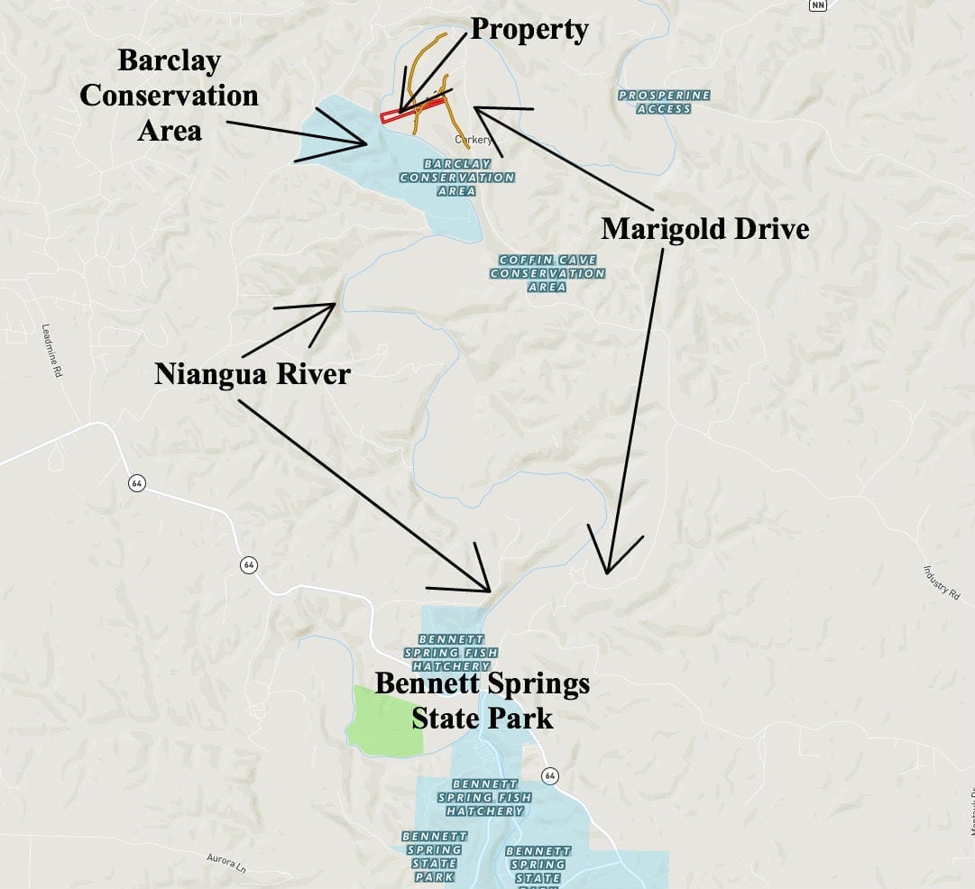
The map above shows the route to the property from Bennett Springs State Park. Bennett Springs has the large fish hatchery where the rainbow trout and brown trout are raised. They are released into the river from there and they populate a 12 mile stretch of the river which includes the riverfront on this property! The red outline on the map above is actually showing a different tract which is just a few hundred feet to the north of this 10 acre tract.
Excellent location, about 1 1/2 hours to Springfield, MO and just a little farther to Branson, MO. Also only about 2 1/2 hours to Kansas City and about the same to St. Louis.
If you would like a nearby address for your G.P.S. you can enter: 30500 Marigold Drive, Lebanon, MO 65536. This address should get you very close to the property BUT please do print out the maps and directions from this listing as it can certainly be confusing on your first trip.
DIRECTIONS: From Lebanon, Missouri go west on Highway 64 for about 10 miles to Bennett Springs State Park. You will come down a long hill as you approach the Niangua River. At the bottom of the hill you will go right (north) onto Marigold Drive. If you cross the Niangua River while you are on Highway 64 then you west just a few hundred feet too far. Once on Marigold Drive, proceed northerly for about 6 1/2 miles until you get to the property on the left side (west side) of the road. While you are on Marigold Drive you will come across a couple of “Y’s” in the road. Just veer left at the “Y’s”.
Printing the maps/directions is a must but having the MapRight app on your phone is BY FAR the best way to get to and to explore this large property. In order to use the MapRight app you just need to download the free app from the Apple Store or from the Google Store (search for “Mapright”, all one word). Please send us an email or call us after you have the app and we can email you the link for the specific interactive map for this property. This is MUCH BETTER than using the map in this listing because when you use the MapRight app on your phone/tablet there will be a colored dot to indicate right where you are (it uses the GPS on your phone). So it is not only helpful in getting to the property but it is very helpful in exploring the property. Seriously, it is awesome…
UPDATE: Mapright has now changed its name to “Land Id” and they have slightly modified their app and their maps. Our interactive maps will still work on your phone and if you download the “Land Id” app you can view the map(s) in the app, but we have been told that in order to view your location while also viewing the map within the app you will need a Land Id account. When we checked, it appears that you can get a free “trial account” for 7 days without having to give Land Id any credit card info (just an email address).
Once you get to the property feel free to walk all around and explore. Also, you can bring your four wheeler or side-by-side if you would like.
Please let us know when you plan to make a trip to the property as there is a gate across the start of the easement road and you will need the combo for the lock.
Normally, when you are looking at a property on a major river like the Niangua River, you will notice that the river frontge is either high on a bluff, or completely in a flood zone. That is not the case with this special acreage. Becuase the Barclay Conservation Area across the river is a large open meadow/pasture, the flood zone mainly covers the Conservation Area, with only a small part of the west side of this property being within the flood zone (see the map below).
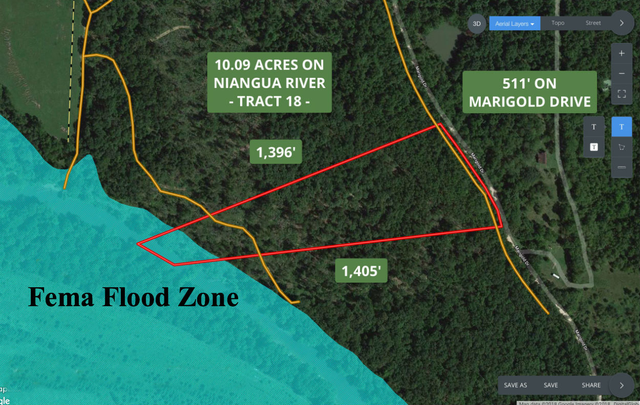
The aerial map above shows the property and FEMA Flood Zone. When you build your home or cabin, you will definitely want to stay out of the flood zone. One of the things that makes this tract very special is that the vast majority of the property is out of the flood zone (very rare on a true river property). The reason that only a small portion of the property is within the flood zone is that the Barclay Conservation Area (just across the river) has a HUGE open bottom field, and that bottom field would have to completely fill with water before the water level could raise onto the majority of the property.
Please click on the link below to see the Deed Assurances for Riverside At The Niangua. If you have any questions at all, please let us know.
To see the additional property covenants at Riverside At The Niangua please click here.
The Deed Assurances include but are not limited to:
- No mobile homes or modular homes are allowed
No portable buildings are allowed
No commerical activity is allowed
Camping is allowed for a maximum of 45 days in a 12 month period.
Residences must be on a minimum 600 square foot concrete foundation and up to two residences are allowed on each tract.
For building/camping purposes, there is a 100 foot setback from most roadways (50 setback from the roadway which crosses over the western side of the property) and a 5 foot setback from side boundaries.
Please click on either the link below or the link above to see all of the property covenants
To see the additional property covenants at Riverside At The Niangua please click here.
Please do click on either of the links to fully familiarize yourself with the property covenants. If these Deed Assurances do not meet with your needs, then we would be happy to be on the lookout for a property which does fully fit your needs.
Also, please note that trees with a stump diameter of more than 8 inches may not be cut, sold or disturbed until the property has been paid for in full.
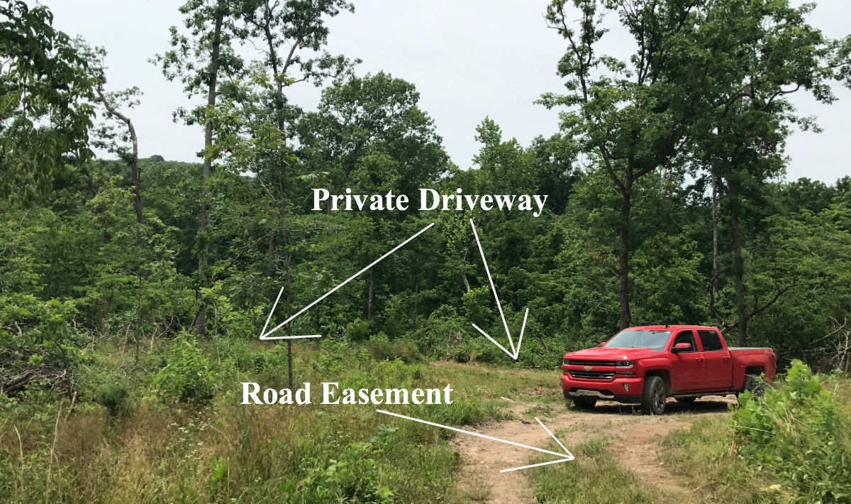
In the photo above we are parked on the private easement road which crosses over the west side of the property. You can see the start of the private driveway which leads down to the site at the river.
This 10+ acre riverfront tract represents an excellent opportunity for building your own home or cabin as we have been told that there are no building permits required in this area! You and your friends/family can build your own cabin without permits or inspections (minimum 600 square foot concrete foundation and all other property covenants do apply).
You can actually build up to two residences on the property. The additional residence could be used as a rental to offset or completely pay for your mortgage payment. Monthly or weekly rentals with access to the river would be very popular.
In the aerial photo above we are looking northerly over the west side of the property.
This large tract is not only versatile for all sorts of uses but it is in an incredible location for enjoying it all year round. This section of the Niangua River is easily one of the most popular sections of river in the entire state!
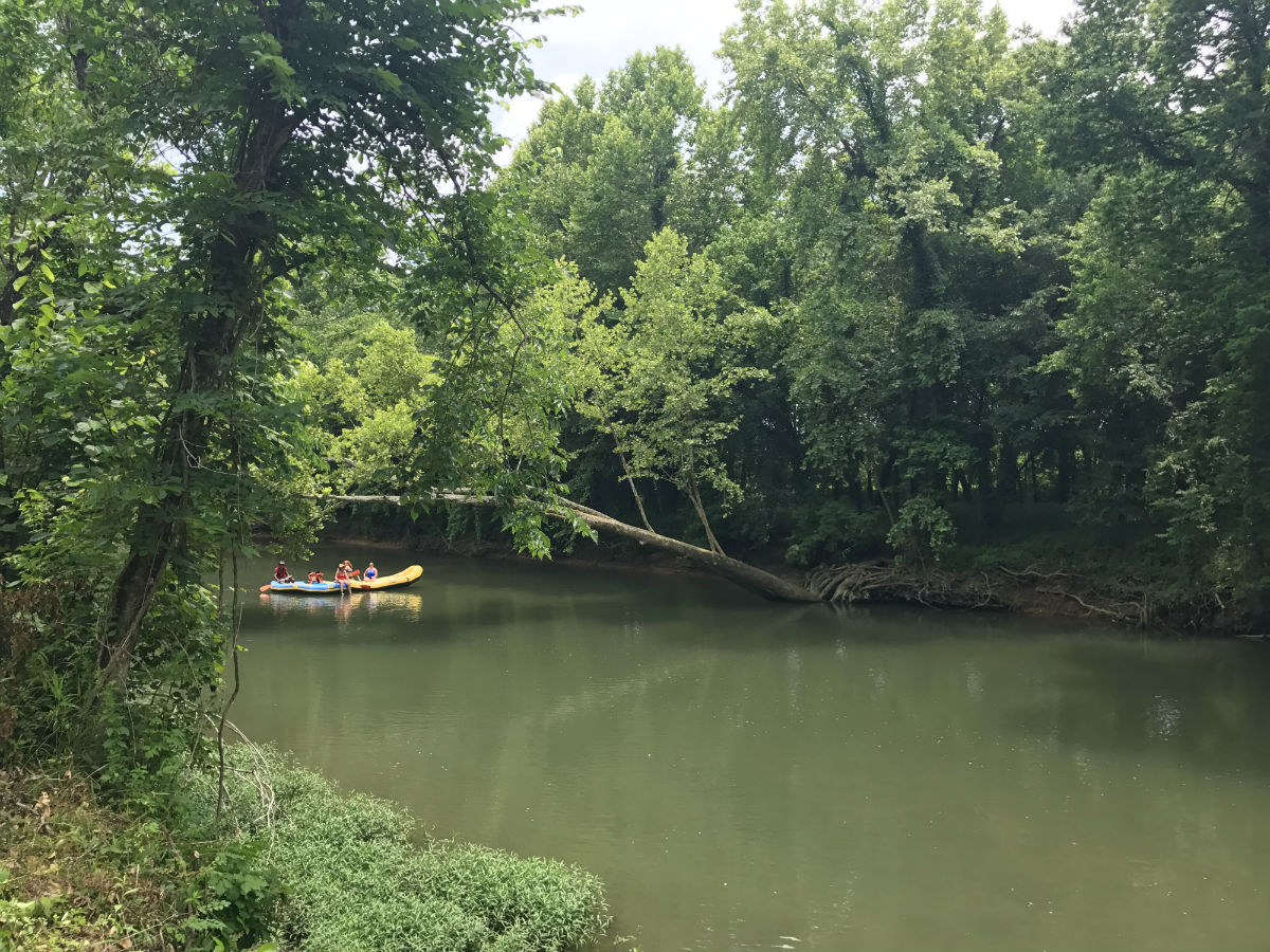
In the photo above we were standing at the river frontage as people floated by. This is a very popular part of the Niangua River that is great for both fishing and floating.
The Barclay Conservation Area is directly across the river from the property. The Conservation Area is several hundred acres of land which you can use and enjoy and it includes an excellent access point to the river. Put your canoe or kayak into the river at the Conservation Area and you can float directly down-river to your private acreage!
Click Here for more information on the Barclay Conservation area.
Click Here for more information on Bennett Springs State Park.

The map above shows the property itself, Bennett Springs State Park (where the trout are raised and released) and the trout fishing section of the Niangua River. The trout fishing section of the Niangua River is shown as the white & black dashed line which DIRECTLY borders the property. The red outline which indicates the property should actually be shown a little farther south as this property is DIRECTLY across from the Barclay Conservation Area (this particular map is from a property which has already been sold).
TERMS OF SALE
The full sales price for this 10 acre riverfront tract is $169,500 and we offer INSTANT owner financing with a $2,500 down payment.
With your $2,500 down payment you will automatically get the reduced annual interest rate of 6 3/4% and the monthly payments will be $1,502.80.
With a $5,000 down payment the interest rate drops to 5 3/4% and the payment drops to $1,391.03 a month. These payments are all based on about a 15 year payment schedule. Property taxes & road maintenance fees total about $300 per year and this is already included in the monthly payment amount. There are NO prepayment penalties and NO hidden fees.
PLEASE NOTE that you have a TWELVE MONTHS to ADD to your down payment in order to reduce your interest rate and payment amount! We want to give ALL of our buyers the opportunity to achieve the lowest interest rate and payment amount possible!
ALSO, if you pay off your property (your loan to us) at any time within the next 5 years you will get a 10% DISCOUNT off of the purchase price of the property! On this property that would save you $16,950 for an early payoff!
It is VERY HARD to find a tract with direct river frontage of any kind in the Missouri Ozarks. It is EVEN MORE RARE to find a tract upon which you can fish for trout, as well as swim, float, kayak and camp!
Your family will love you and your friends, family and neighbors will be very jealous BUT with 10.09 acres and 194 feet of direct river frontage you can invite them along for the weekend too…
If this is the property for you then please choose your initial down payment amount in the box below by choosing at least a $2,500 down payment amount (if the property is still available) and you can pay with a debit or credit card. Also please feel free to send us an email or give us a call and we can answer any questions or complete the transaction over the phone. Our number in the office is 417-767-2223 or you can reach us anytime by email at [email protected].


