SORRY, THIS PROPERTY HAS BEEN SOLD!
Below, you will see the “MapRight” Interactive Map for this property. The boundaries are only approximate but this property has been surveyed with the corners marked (several years ago).
Please visit our “F.A.Q.” page to watch a short video explaining how the free MapRight app can be helpful in exploring your property.
Huge 37 acre property comprised of three adjacent fully surveyed tracts. Located in Douglas County, Missouri which is well known for hunting, fishing, four-wheeling and recreation.
Please click on the photos on the right side of the screen to enlarge them and to get a short description of each photo. Farther down in this listing, you will find an interactive map, as well as a couple of videos and numerous pictures and maps.
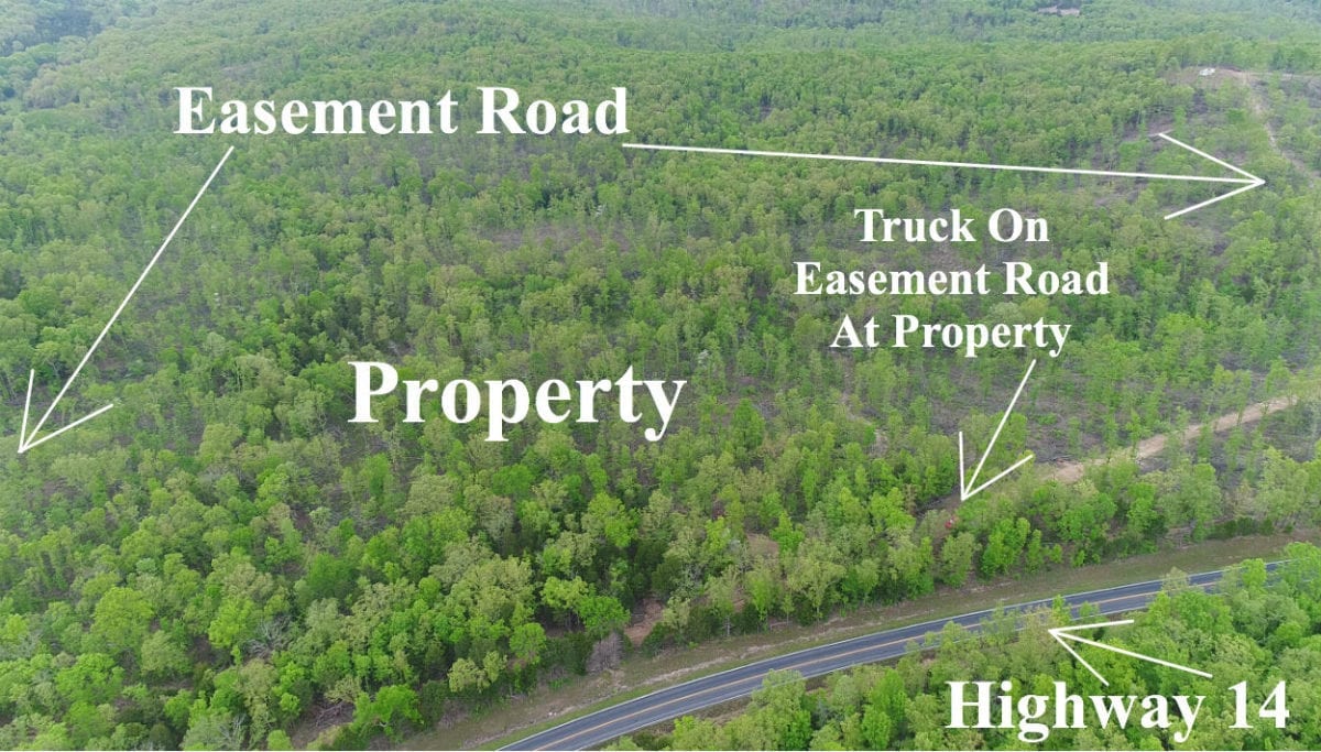
In the aerial photo above we are looking north at the property. It is very close to the paved road and goes back to the north for maximum privacy.
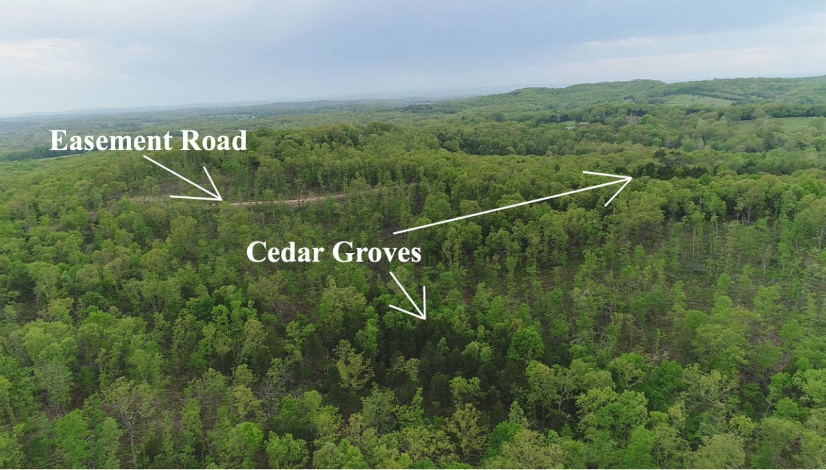
In the aerial photo above we are above about the middle of the property. We are looking southerly toward the gravel easement road on the south side. You can see multiple cedar groves on the property.
The sales price on this 37 acres is $73,500. With $500 down the monthly payments will be $790. This is about a 15 year payment schedule and an annual interest rate of 9 3/4%.
With $1,500 down the interest rate drops to 7 3/4% and the payment drops to $695 a month. With $2,500 down the interest rate drops to 6 3/4% and the payment drops to $645 a month. With $5,000 down the interest rate drops to 5 3/4% and the payment drops to $585 a month. These payments are all based on about a 15 year payment schedule. Property taxes are only about $180 a year and are already included in the monthly payment. There are NO prepayment penalties and NO hidden fees.
PLEASE NOTE that you have a full 12 months to ADD to your down payment in order to reduce your interest rate and payment amount! We want to give ALL of our buyers the opportunity to achieve the lowest interest rate and payment amount possible!
ALSO, if you decide to pay off your property (your loan to us) at any time within the next 5 years you will get a 10% DISCOUNT off of the purchase price of the property. On this property that would save you $7,350 for an early payoff!
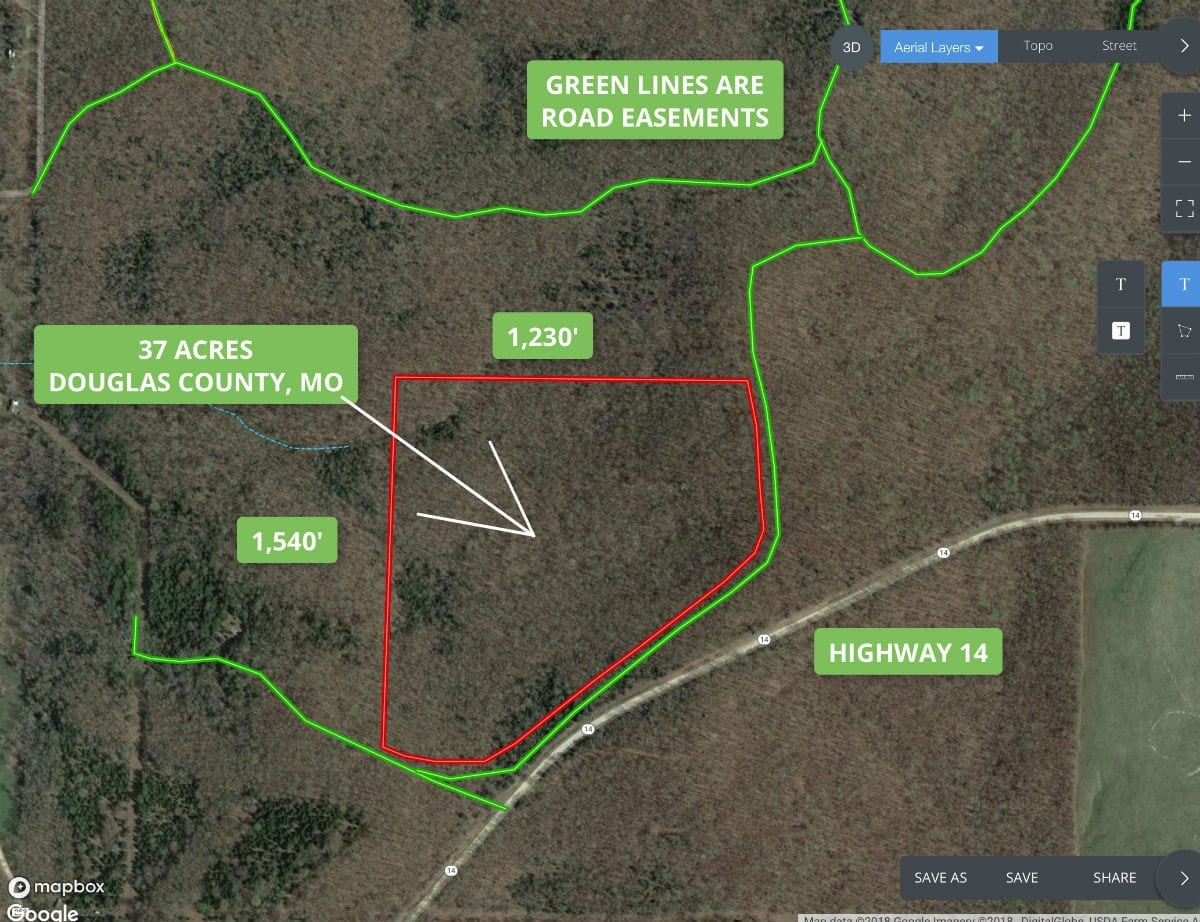
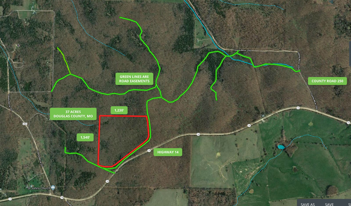
The aerial map above shows how the property is situated and its approximate dimensions. It borders a gravel easement road along its south and east side.
The properties at Hawk’s Roost were logged within the last couple of years. Portions of this property were logged heavily and portions were not. The drone videos in this listing are recent and give you a good look at the property.
PLEASE NOTE: This property was leased out for a while and the people using the property had been camping in tents near the southwest corner. There will probably be “trash” that was left over from their camping expedition. The videos we have were taken before they had camped on the property so they do not show the “camping area”. We have been told that they did a fairly good job of cleaning things up BUT we have not been out there to verify that. Just wanted everyone to know!
Please refer to our interactive map (above) for additional property views and information. Please note that the boundary lines and measurements are approximate. This interactive map is fairly new for us and if you have a chance we would love to have your feedback on it. Is it awesome? Is it great? Is it confusing? We would like to know!
Also, please note that on the interactive map it seems to work best if you click the “View Full Screen” option. Once you are in the “Full Screen” option you can select “Topo” to see a topographic map which does a good job of showing how the property is situated. Also, we can email you the direct link for this interactive map of the 37 acres, so you can view it in your phone or tablet when you make the trip to the property (you will need to download the MapRight app to your phone/tablet).
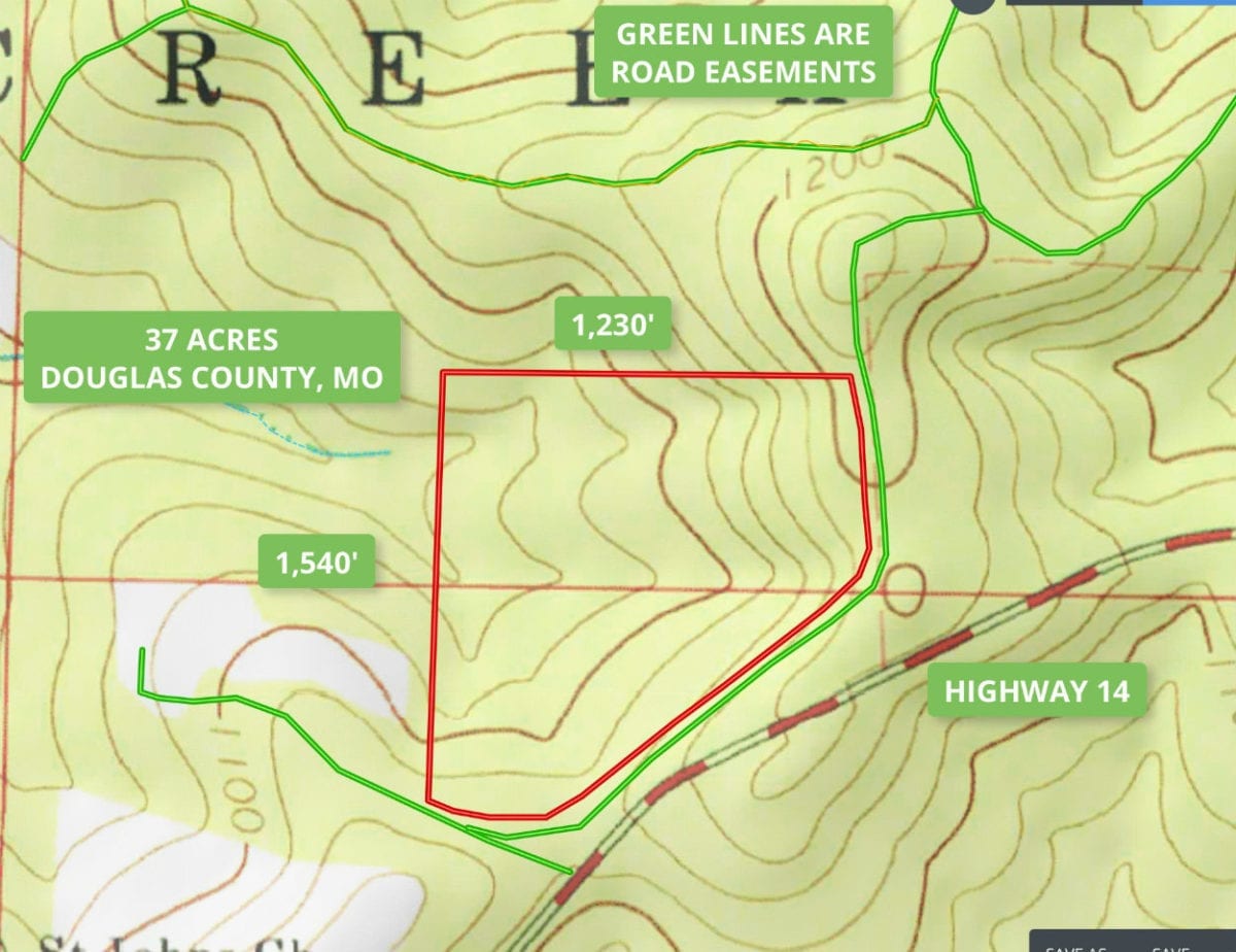
The topo map above shows how the 37 acres is situated. It is the highest by the gravel road and slopes down as you go north and west. There are quite a few areas that would be level enough for a large buildings site/campsite.
In the video below, we take a look at the property and area with our interactive map:

Video Intro HR3234
In the video below, we explore the property from the ground:

Video Ground HR3234
In the last video (below) we explore the property from the air, with our drone:

Video Drone HR3234 Narrated
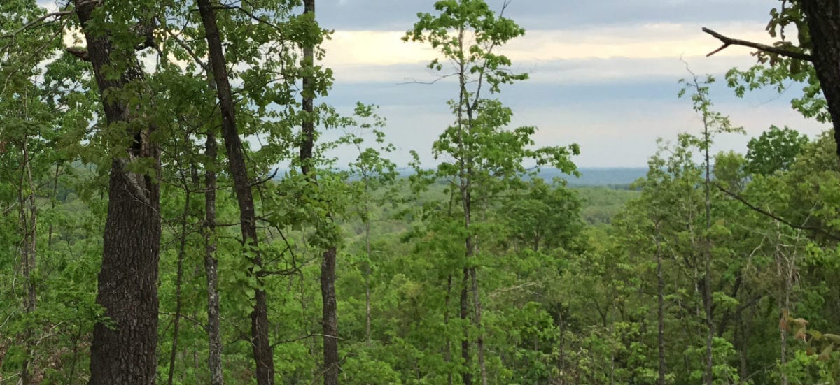
The photo above shows just one of the potential views from the property. It could be easily improved with the clearing of a few small trees.
The property is an excellent area for wildlife including numerous white-tailed deer and large numbers of turkey. Great privacy with the dead-end road but still close to several towns including Ava, West Plains and Mountain Grove.
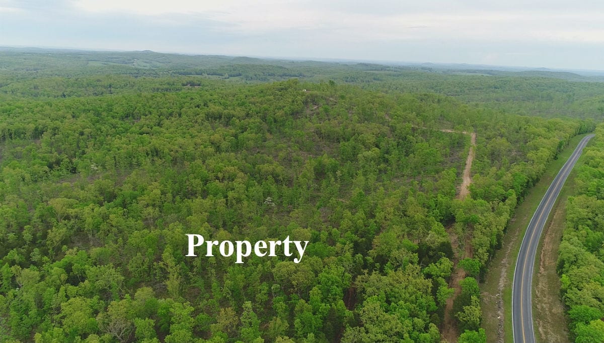
In the aerial photo above we are looking easterly and the land is on the left of the gravel road.
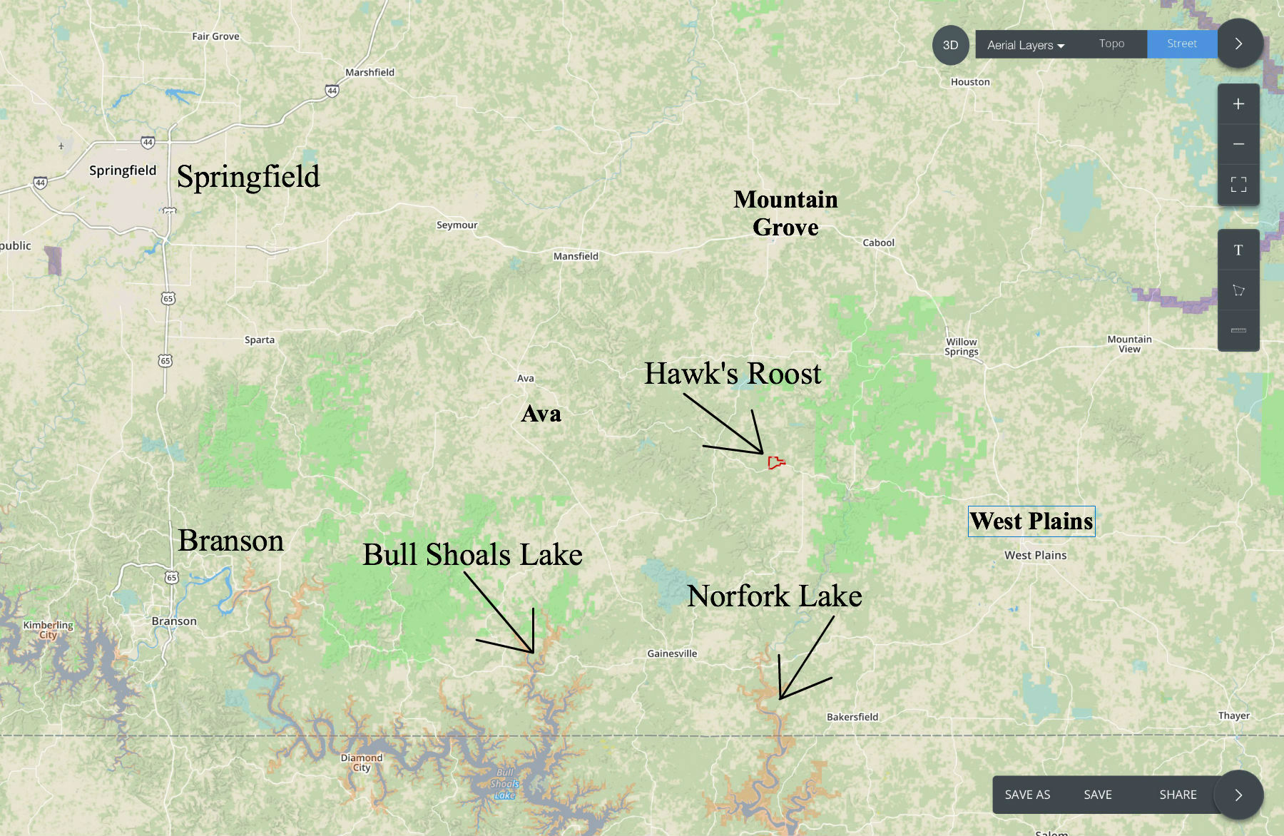
The 37 acres is private but is still very centrally located with a short drive to several towns. The town of Springfield is about 1 1/2 hours from the property and is the largest city in the Ozarks.
Please print the map above (as well as the other maps and directions) when you visit the property. We will be happy to email, text, fax or mail the maps and directions to you if you would like!
Feel free to make the trip to check out the property. From Mountain Grove, Missouri go south on Highway 95 for about 20 miles to Highway 14. Go east on Highway 14 for about 6-7 miles and then go north (left) onto the unmarked gravel easement road which goes to the property. You can also go to County Road 250 on the left (north) and then take County Road 250 to the gravel easement roads (shown on the map above and below). Within just 3-4 miles of this property you will find thousands of acres of National Forest which can be used for additional hunting, recreation and trail riding. Also, within just a few miles of this acreage you will find the very popular North Fork River which is excellent for fishing, swimming, floating and canoeing.
Plan on driving a truck or an SUV to this secluded property. As with all easement roads, there may be some rough spots and it is always nice to have the extra clearance that is provided by a truck or SUV.
As we mentioned earlier, we will be happy to email you the “MapRight” link which will be very helpful when you visit the property. If you have a smartphone you can download the MapRight app and you will be able to see exactly where you are when you view the property. This is BY FAR the best way to view the property. Although we generally do have cell service in the area (but not always), it is a very good idea to get your MapRight link in order while you are in town. Then, just leave it on your phone while you drive to the property. Once it is loaded on your phone, MapRight uses the GPS signals so even without good service it will still work (as long as the map is already loaded on your phone).

In the photo above we are parked on the private easement road with the land on the left.
This property has multiple areas that could be great for building or camping. The private natural glade areas are totally secluded and have an extremely private feel to them.
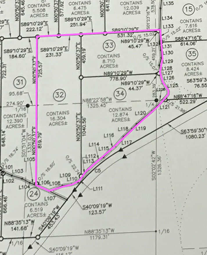
The above survey map shows the three tracts that comprise the 37 acres. They are Tracts 32, 33 and 34. As the tracts are fully surveyed, this is an excellent opportunity to potentially keep one or more tracts for yourself and you could plan on giving one to the kids, or possibly selling one or more of them and keeping the tract of your choice.
Like all of our properties, this 37 acres is subject to the 6 basic restrictions as shown on our website (no mobile homes, etc.). Homes or cabins built on the property must have a minimum concrete foundation size of 600 square feet (a simple 20 X 30 cabin would meet this requirement). Camping is allowed for up to 45 days in a 12 month period.
To see the standard Deed Assurances please click here.
As with all of our properties, there is a 100 foot setback from all shared roadways (highway, county road and easement roads) for utility purposes. Also please note that timber with a stump diameter larger than 8 inches may not be cut, sold or removed until the property has been paid for in full (we can generally give written exceptions for creating building sites and driveways).
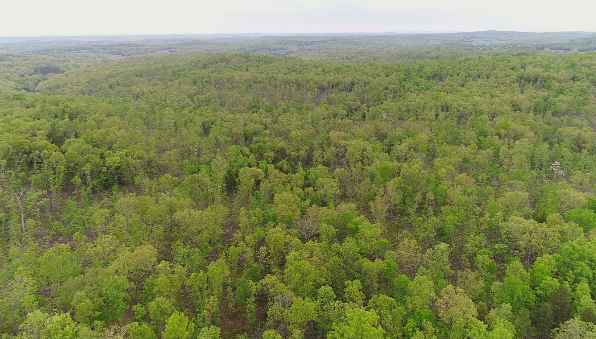
In the aerial photo above we are looking over the property. Great mix of timber and a very usable property.
This area is FULL of wildlife including deer and turkey. Also, within just a few miles of the property you will find thousands of acres of National Forest which can be also used for hunting and recreation. Also, within just a few miles you will find the VERY popular North Fork River and Bryant Creek. Perfect for fishing, floating, swimming canoeing and kayaking.
The sales price on this 37 acres is $73,500. With $500 down the monthly payments will be $790. This is about a 15 year payment schedule and an annual interest rate of 9 3/4%.
With $1,500 down the interest rate drops to 7 3/4% and the payment drops to $695 a month. With $2,500 down the interest rate drops to 6 3/4% and the payment drops to $645 a month. With $5,000 down the interest rate drops to 5 3/4% and the payment drops to $585 a month. These payments are all based on about a 15 year payment schedule. Property taxes are only about $180 a year and are already included in the monthly payment. There are NO prepayment penalties and NO hidden fees.
PLEASE NOTE that you have a full 12 months to ADD to your down payment in order to reduce your interest rate and payment amount! We want to give ALL of our buyers the opportunity to achieve the lowest interest rate and payment amount possible!
ALSO, if you decide to pay off your property (your loan to us) at any time within the next 5 years you will get a 10% DISCOUNT off of the purchase price of the property. On this property that would save you $7,350 for an early payoff!
If this is the property for you then please choose your initial down payment amount in the box below (if it is still available) and you can pay with any debit or credit card. Also please feel free to send us an email or give us a call and we can answer any questions or complete the transaction over the phone. Our number in the office is 417-767-2223 or you can reach us anytime by email at [email protected].


