
Riverside At The Niangua is truly one of the most exciting and unique projects you will ever see. This small, private area contains a very limited number of tracts with TRUE frontage on the wildly popular Niangua River in the beautiful Missouri Ozarks.
Not only is the Niangua River one of the most popular and beautiful rivers in the state, but this particular section of the Niangua is well known to be a proven area for some of the most amazing fishing you can find ANYWHERE. Trout and bass fishing in this section of the river is popular year after year. This section is also home to a number of small resorts and outfitters as this particular section is EXCELLENT for canoeing, kayaking, swimming and floating.
Bennett Springs State Park is just a few miles up the river from these tracts and the Park is regularly stocked with brown and rainbow trout, which are raised in the waters of the river. People come from all over the country to fish, float, kayak and canoe right here!
Properties with TRUE frontage on a named river are rare. Properties with TRUE frontage on the Niangua River, just down from Bennett Springs State Park are more than rare!
Could it get any better…….Yes! This particular portion of the Niangua River is what is referred to as a “White Ribbon Section” for trout fishing! The “White Ribbon” designation means that this section is managed specifically for catching rainbow and brown trout. This is only a 12 miles section along the entire Niangua River that is designated as a “White Ribbon Section” for trout fishing. This means more fishing and fun for you and your family!
For more information on the trout fishing click on the link below. It is a link to an article written by a man who was fishing for trout in the area adjacent to the NRO resort which is about one mile upriver from the property.
To check out the trout fishing article please click here.
Toward the end of the above article, the author recommends staying in a cabin at “One-eyed Willie’s” campground, which is just across the river from this property (and down a few hundred feet).
By the way, the river is also well known for bass fishing as well as several other species. So if trout fishing isn’t your thing you can go after the bass, catfish or sunfish. Maybe fishing isn’t your thing at all. No worries! This section of the river is great for swimming, exploring, kayaking or just generally hanging out. How about a river side BBQ or campfire?
Tract 7 at Riverside At The Niangua is fully surveyed and as 10.18 acres in size.
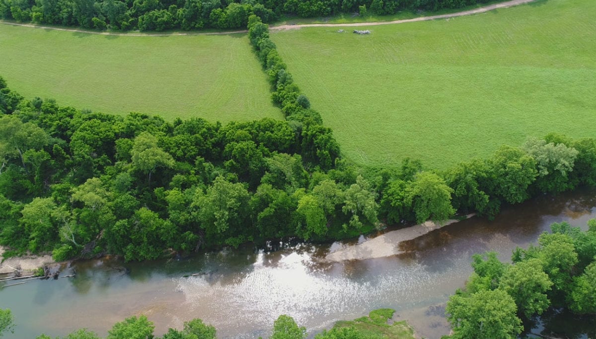
In the aerial photo above we are looking over the Niangua River at the property. It features approximately 350 feet of direct frontage on the Niangua River along its entire northwest side, giving you plenty of space for shoring your canoes or kayaks, fishing for trout, bass and other fish or setting up a few beach chairs for the family and friends.
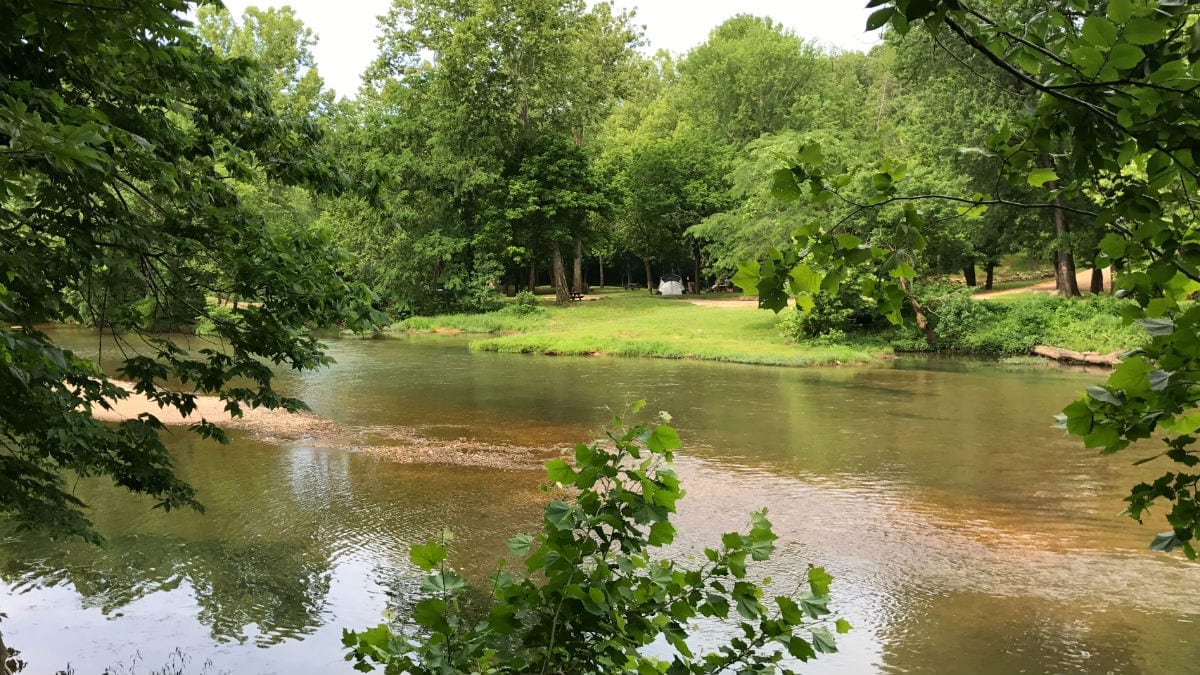
The photo above was taken directly on the property, looking down the river. The Niangua River is very clear in this area and is great for swimming, fishing and floating.
The sales price on this 10 acre tract is $89,500. With $500 down the monthly payments will be $965. This is about a 15 year payment schedule and an annual interest rate of 9 3/4%. With $1,500 down the interest rate drops to 7 3/4% and the payment drops to $855 a month. With $2,500 down the interest rate drops to 6 3/4% and the payment drops to $795 a month. With $5,000 down the interest rate drops to 5 3/4% and the payment drops to $725 a month. These payments are all based on about a 15 year payment schedule. Property taxes & maintenance fees (for the easement roads) will only be about $280 a year and this is already included in the monthly payment amounts. There are no prepayment penalties, no hidden fees and no balloon payments.
PLEASE NOTE that you have a full 12 months to ADD to your down payment in order to reduce your interest rate and payment amount!
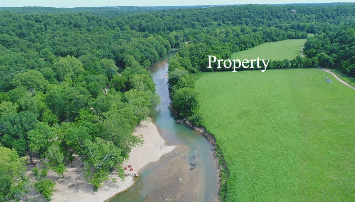
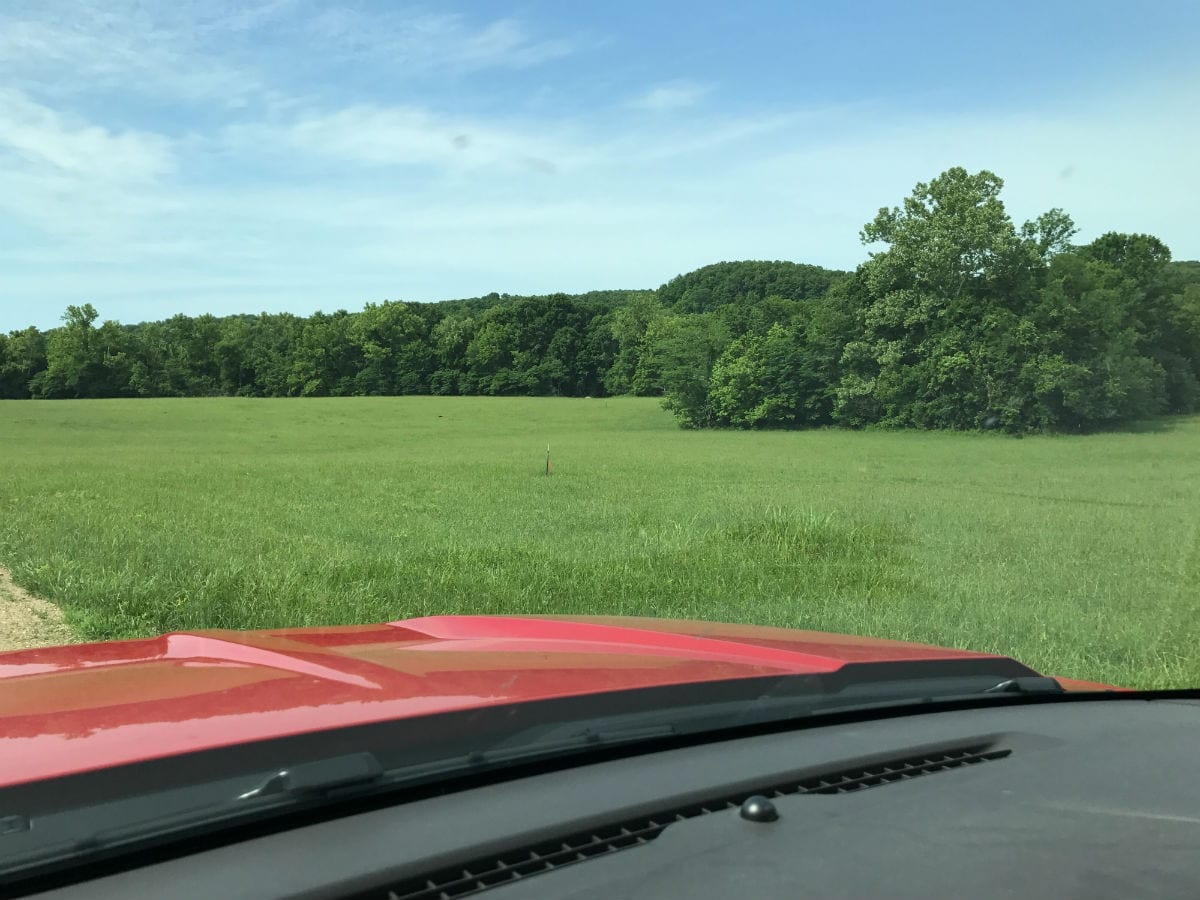
The aerial photo above was taken just across the river, looking easterly at the property. Part of the lower field and upper field (in the distance) are both on the property.
As the property was logged within the couple of years, it could use a few days worth of “clean-up”. There are some tree limbs and brush scattered around which could be clean up, burned, removed or just left where the are. Also, to enjoy this property to its fullest it could use some type of trail cleaned up leading to the water. We were able to drive a four wheeler to the water but the river front would be much more usable with a better trail to the river.
If you are interested in building some great “sweat equity” on this property, consider opening up a trail to the river or cleaning up some of the brush/limbs, which could increase the value dramatically. The brush/limbs will also give you an excellent source of free firewood for those river-side bonfires or for a nice campfire to cook your fish!

The aerial map above shows how the property is situated as well as the approximate measurements. This tract borders Marigold Drive along its southeast side (for about 65 feet) and it borders the Niangua River along its northwest side for about 350 feet. The property is level coming off of Marigold Drive in the “Upper Field”. As you move toward the river you will get to the wooded area which is where the property slopes down steeply until you get to the “Lower Field’. The lower field stays level until you get to the next tree line where the property slopes down to the water.
There is an easement road (shown on the map above) which gives you good access with a truck or suv down to the “Lower Field”.
Although portions of this property were logged within the last 1-2 years there is still mature timber including white oak, red oak, hickory and cedar. Please note that the timber may not be cut or sold until the property has been paid for in full ( we can often make written exceptions for creating trails/building sites).
There are multiple areas on the property that would be suitable for building, camping or hunting.
Check out the interactive map below!
Please refer to our interactive map above for additional property views and information. Please note that the boundary lines and measurements are approximate. This interactive map is BRAND NEW for us and if you have a chance we would love to have your feedback on it. Is it awesome? Is it great? Is it confusing? We would like to know!
Also, please note that on the interactive map it seems to work best if you click the “View Full Screen” option. Once you are in the “Full Screen” option you can select “Topo” to see a topographic map which does a good job of showing how the property is situated.
The interactive map was created with a program called “MapRight”. If you download the free MapRight app to your smartphone or tablet then we can email you the link for this specific interactive map. This is VERY USEFUL when visiting the property because when you click on the link that we can email you (and then open the link within the MapRight app) then the Interactive Map will open on your device AND there will be a colored dot to indicate right where you are. It is useful for getting to the property and even more useful for walking around the property. We can help you with any of this as it can be confusing the first time you use MapRight.

The topo map above shows how the land “lays”. Each line indicate an elevation change of 20 feet so when the lines are close the land is steep and when the lines are far apart the land is flat (or nearly flat). The land is basically flat coming off the county road and when you get to the tree line it slopes down steeply to the “Lower Field”. Although you could potentially put a road/trail down the steep part, it is much easier to use the easement road (pink dotted line on the topo map) which goes down the hill to the south, and then curves back to (and across) the property. As shown on the map above, there is also a short road easement across the eastern side of the property. These are private road easements for property owners only, not for the public.
This property is private and secluded with an amazing amount of wildlife. On the property you can expect to find whitetail deer as well as wild turkey. This property has a proven track record for both deer and turkey hunting. In the river you can expect to find trout, bass and many other types of fish. Although this tract is very private it is only about 15 miles from Lebanon, Missouri which is the largest regional city in the area.
In the video below we take a look at the tract and its surrounding area. This is a great video to watch first as it shows the property, the river and the nearby areas:
$500 down ON trout fishing river in the Ozarks! – InstantAcres.com – ID#RN07
In our second video below, we explore the property with our drone:

10 acres ON Trout Fishing River in the Ozarks! – Owner Financing! ID#RN07 – Drone Video
In the short video below, we check out the property at the river:

$500 down & no credit checks for 10 acres on the river in the Ozarks! – ID#RN07
The next video is quite long. In this video we start on Marigold Drive then pull into the “Upper Meadow” at the east side of the property. We then take the gravel easement road down to the “Lower Meadow” and then finally we check out some of the river frontage on the property:
![10+ acres w/ 350' of TROUT FISHING frontage only $500 down! - [ Owner Financed Land for Sale! ]](https://i.ytimg.com/vi/Jj3gaSlAPJA/hqdefault.jpg)
10+ acres w/ 350' of TROUT FISHING frontage only $500 down! – [ Owner Financed Land for Sale! ]
Please click on the photos on the right side of the screen to enlarge them and to get a short description of each photo.

Excellent location, about 1 1/2 hours to Springfield, MO and just a little farther to Branson, MO. Also only about half a day’s drive to Kansas City and even closer to St. Louis.
If you would like a nearby address for your G.P.S. you can enter: 30500 Marigold Drive, Lebanon, MO 65536. This address should get you very close to the property BUT please do print out the maps and directions from this listing as it can certainly be confusing on your first trip.
DIRECTIONS: From Lebanon, Missouri go west on Highway 64 for about 10 miles to Bennett Springs State Park. You will come down a long hill as you approach the Noangua River. At the bottom of the hill you will go right (north) onto Marigold Drive. If you cross the Niangua River while you are on Highway 64 then you west just a few hundred feet too far. Once on Marigold Drive, proceed northerly for about 6 1/2 miles until you get to the property on the left side (west side) of the road. While you are on Marigold Drive you will come across a couple of “Y’s” in the road. Just veer left at the “Y’s”. Printing the maps will help.
Once you get to the property feel free to walk all around and explore. Also, you can bring your four wheeler or side-by-side if you would like. If you are in a truck or an suv you can take the easement road down toward the “Lower Field” and toward the river. PLEASE NOTE that if it has been raining, the lower field will likely be soft and you could easily sink in if you drive off of the easement road. In these conditions it would probably be best to park your truck on the easement road and just walk across the lower field to the river.
Please let us know when you plan to make a trip to the property as there is a gate across the start of the easement road. You will need the combo for the lock.
As these properties are high-quality investment grade tracts, they have similar Deed Assurances to some of our other upscale developments such as Fiery Fork Ridge and Timber Shoals Ranch. As Riverside At The Niangua is designed as an upscale river front community, there are a few simple Deed Assurances which have been designed to be minimally restrictive while still keeping your property value high.
Please click on the link below to see the Deed Assurances for Riverside At The Niangua. If you have any questions at all, please let us know.
To see the additional property covenants at Riverside At The Niangua please click here.
The Deed Assurances include but are not limited to:
- No mobile homes or modular homes are allowed
- No portable buildings are allowed, even if attached to a foundation
- No commerical activity is allowed
- Camping is allowed for a maximum of 45 days in a 12 month period
- Residences must be on a minimum 600 square foot concrete foundation and up to two residences are allowed on each tract.
- For building/camping/storage purposes, there is a 100 foot setback from roadways and a 5 foot setback from side boundaries.
- Please click on either the link below or the link above to see all of the property covenants
Here is the link one more time:
To see the additional property covenants at Riverside At The Niangua please click here.
Please do click on either of the links to fully familiarize yourself with the property covenants. If these Deed Assurances do not meet with your needs, then we would be happy to be on the lookout for a property which does fully fit your needs.
Also, please note that trees with a stump diameter of more than 8 inches may not be cut, sold or disturbed until the property has been paid for in full.
In the summer time aerial photo above we are facing north over the Niangua River and the property is up on the right.
This 10 acre waterfront tract represents an excellent opportunity for building your own home or cabin as we are told that there are no building permits required in this area! You and your friends/family can build your own cabin without permits or inspections (minimum 600 square foot concrete foundation).
PLEASE NOTE that although you can build basically anywhere on this property (subject to the setbacks from the roadways) that the “Lower Field” is within the 100 year flood zone. If you were to build in this area you would need to elevate your structure to get it out of the flood zone which will add quite a bit to the cost of building. The “Upper Field” and the wooded hillside would be out of the 100 year flood zone and would be much more suitable building site options.
The “Upper Field” provides numerous potential building sites for a home of virtually any size. There is easily enough space in this “Upper Field” to have a huge house and yard as well as a large shop.

We created the aerial map above to give everyone an idea about how much good, usable area there is on the 10 acres. The large pink rectangles represent a 3,000 square foot foundation which would be an enormous home (a two-story home with this foundation would be 6,000 square feet). They could also represent a huge shop or barn. The smaller pink rectangles represent a more standard house foundation at 1,200 square feet (2,400 square foot two-story home). Although you could potentially build in the lower field you WOULD BE in the flood zone and you would need to elevate your structure with a fully engineered concrete foundation. The upper field provides “High & Dry” building sites and as you can see on the aerial above, there is more than enough room (and locations) for even the largest home and garage.
You can actually build up to two residences on the property. The additional residence could be used as a rental to offset or completely pay for your mortgage payment. Monthly or weekly rentals with access to the river would be very popular.
![]()
The winter time photo above was taken at the west side of the “Upper Field” (looking down toward the “Lower Field”) – you could trim the smaller trees and have an excellent view of the river valley!
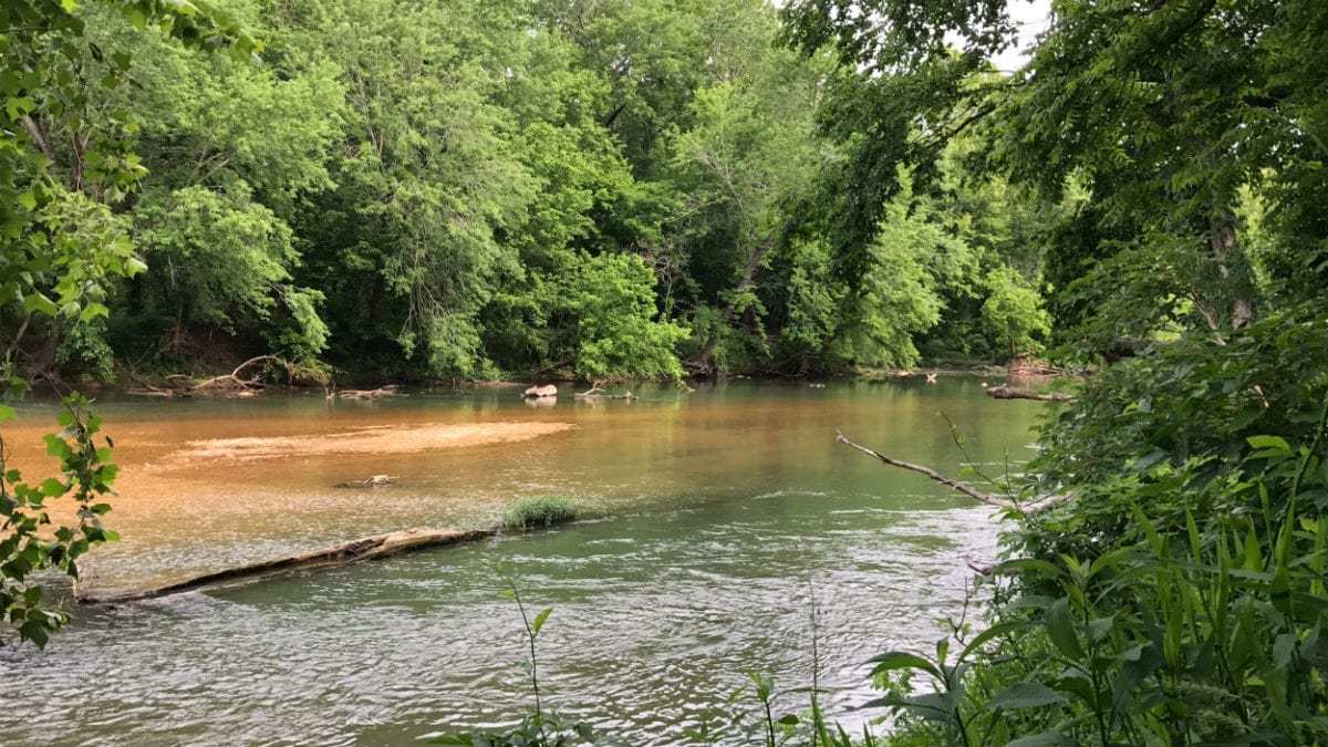
In the photo above we are looking across the “Lower Field” on the property with the river is the distance.
Not only is this tract just a few miles from both Bennet Springs State Park, it is within about a mile of the Barclay Conservation area. This large tract is not only versatile for all sorts of uses but it is in an incredible location for enjoying it all year round. The Niangua River is rated as one of the top trout fishing rivers in the country!
Click Here for more information on the Barclay Conservation area.
Click Here for more information on Bennett Springs State Park.

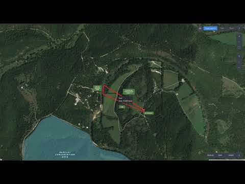
The map above shows the property itself, Bennett Springs State Park (where the trout are raised and released) and the trout fishing section of the Niangua River. The trout fishing section of the Niangua River is shown as the white & black dashed line which DIRECTLY borders the property.
The sales price on this 10 acre tract is $89,500. With $500 down the monthly payments will be $965. This is about a 15 year payment schedule and an annual interest rate of 9 3/4%. With $1,500 down the interest rate drops to 7 3/4% and the payment drops to $855 a month. With $2,500 down the interest rate drops to 6 3/4% and the payment drops to $795 a month. With $5,000 down the interest rate drops to 5 3/4% and the payment drops to $725 a month. These payments are all based on about a 15 year payment schedule. Property taxes & maintenance fees (for the easement roads) will only be about $280 a year and this is already included in the monthly payment amounts. There are no prepayment penalties, no hidden fees and no balloon payments.
PLEASE NOTE that you have a full 12 months to ADD to your down payment in order to reduce your interest rate and payment amount!
In the photo above we are standing on the property looking across the Niangua River.
Do not wait on this one! It is VERY RARE to find a tract with direct river frontage of any kind in the Missouri Ozarks. It is EVEN MORE RARE to find a tract upon which you can fish for trout, as well as swim, float, kayak and camp!
Your family will love you and your friends, family and neighbors will be very jealous BUT with 10 acres and 350 feet of river frontage you can invite them along for the weekend too…


