SORRY, THIS PROPERTY HAS BEEN SOLD!
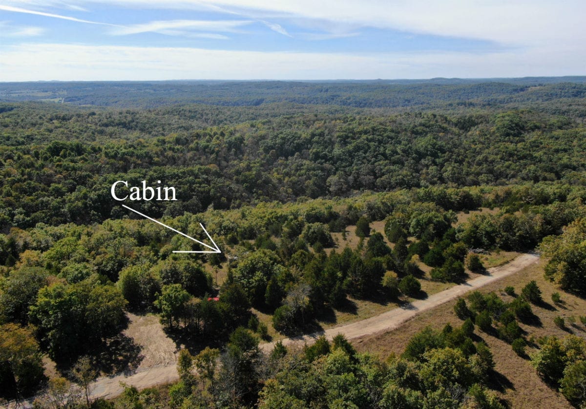
In the aerial photo above we are looking south over the north side of the property. You can see the remains of the little cabin which was never completed.

A fall view to the south from the property. Wow!
The sales price on this 8 acre tract is $32,500. With $500 down the monthly payments will be $340. This is about a 15 year payment schedule and an annual interest rate of 9 3/4%. With $1,500 down the interest rate drops to 7 3/4% and the payment drops to $295 a month. With $2,500 down the interest rate drops to 6 3/4% and the payment drops to $270 a month. With $5,000 down the interest rate drops to 5 3/4% and the payment drops to $230 a month. These payments are all based on about a 15 year payment schedule. Property taxes willonly be about $65 a year and are current. There are no prepayment penalties, no hidden fees and no balloon payments.
PLEASE NOTE that you have a full 12 months to ADD to your down payment in order to reduce your interest rate and payment amount!
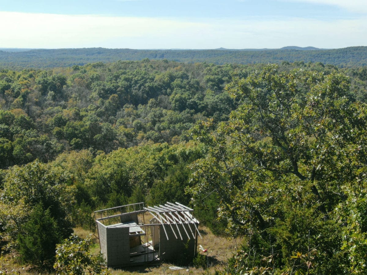
The photo above shows what is left of the small cabin that someone had started to build on the property.
This 8 acre tract offers good access as well as an absolutely amazing view. The property is situated on a private gravel easement road about 40 miles east of Springfield, Missouri and about three miles west of the town of Mansfield, Missouri.
This property offers an open glade area, mature timber, a small creek bed, privacy and views for miles. This tract does have the “remains” of a small cabin which someone apparently started to build years ago. The “remains” probably have no value other that possibly re-using some of the building materials. They did pick a nice building site, though. The spot where the little cabin was being built is very private and out of sight of the road but it has views to the south for miles!
Please refer to our interactive map above for additional property views and information. Please note that the boundary lines and measurements are approximate. This interactive map is BRAND NEW for us and if you have a chance we would love to have your feedback on it. Is it awesome? Is it great? Is it confusing? We would like to know!
The interactive map was created with a program called “MapRight”. If you download the free MapRight app to your smartphone or tablet then we can email you the link for this specific interactive map. This is VERY USEFUL when visiting the property because when you click on the link that we can email you (and then open the link within the MapRight app) then the Interactive Map will open on your device AND there will be a colored dot to indicate right where you are. It is useful for getting to the property and even more useful for walking around the property. We can help you with any of this as it can be confusing the first time you use MapRight.
Also, please note that on the interactive map it seems to work best if you click the “View Full Screen” option. Once you are in the “Full Screen” option you can select “Topo” to see a topographic map which does a good job of showing how the property is situated. You can also see a topo map below:
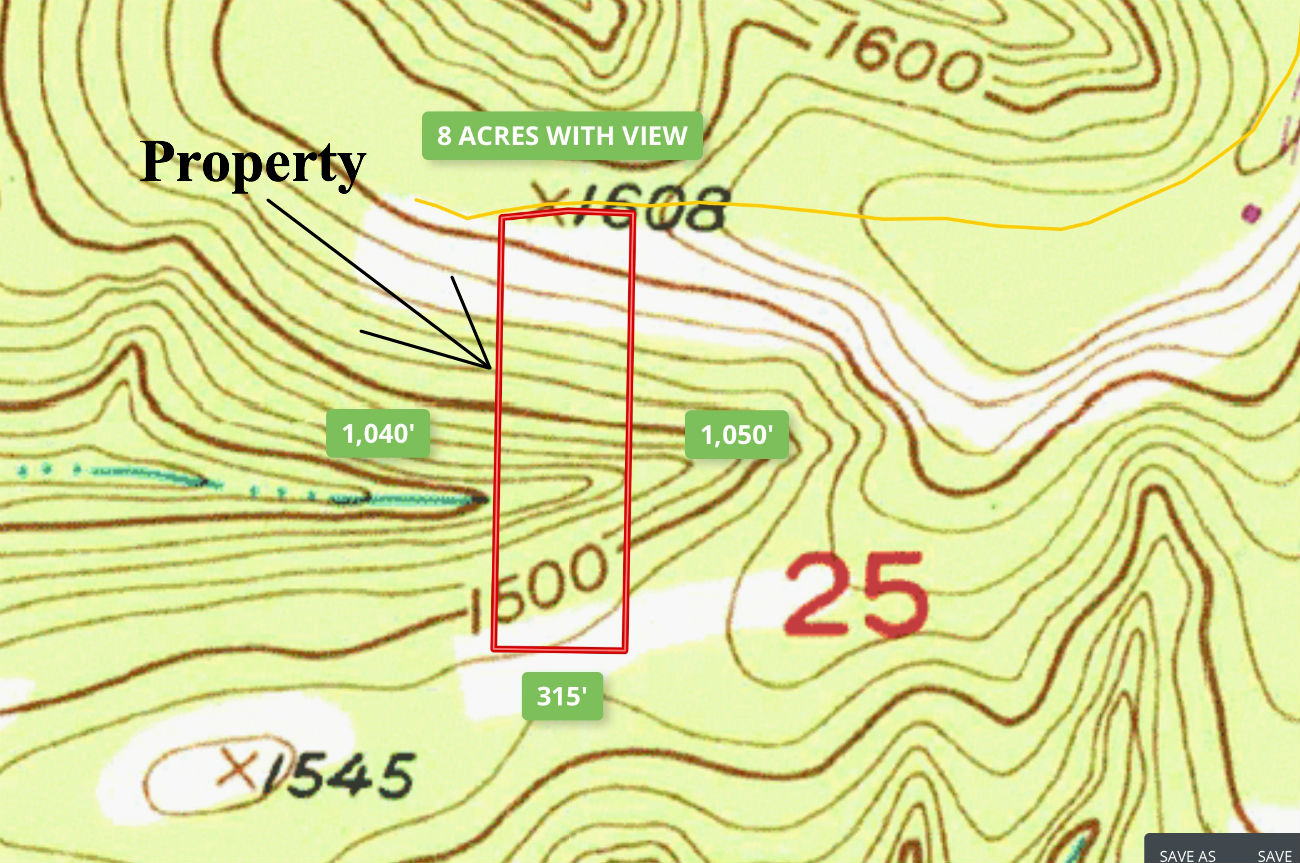
This tract measures about 315 feet east to west and about 1,040 feet north to south. It is highest on the north side (at the road) and slopes down as you move to the south. It slopes down all the way to a small creek (probably a seasonal creek) then as you continue going south it slopes back up again on the other side of the creek. Most of this property is steep, which is what gives it the incredible views. The best building site would possibly be about where the little “cabin” is located. You could certainly build farther to the south on the property but that would likely mean having someone come in with a dozer to make some type of long driveway going down the hill.
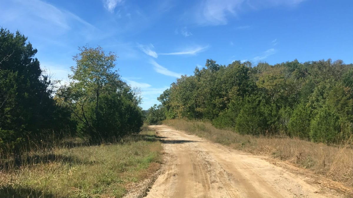
In the photo above we are facing west on the easement road with the property on the left.
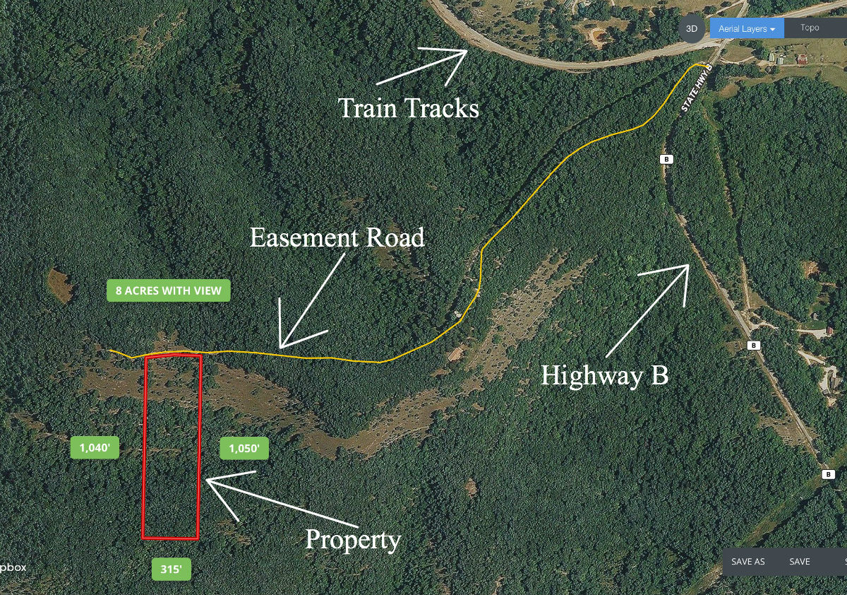
The map above shows the property which is Tract 2B. It is bordered along its entire north end by the gravel easement road. The property slopes down off of the easement road which provides the excellent views.
In our overview video below, we check out the property and surrounding area using our Mapright software:
In our second video below, we explore more of the property (this time on foot):
In our last video, we check out the property from the air with our drone:
Click on the photos on the right side of the screen to enlarge them and to get a short description of each photo.
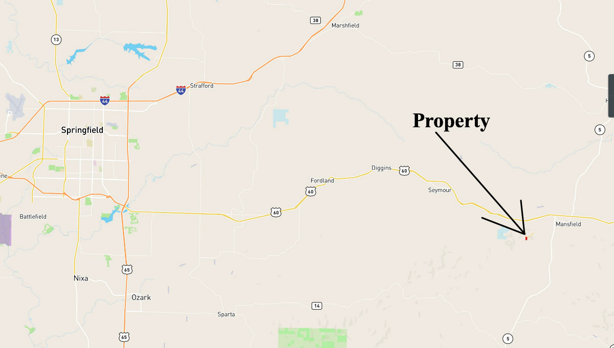
The property is a short drive from Springfield, Missouri. It is located between the small towns of Mansfield, Missouri and Seymour, Missouri.
The area is full of deer and wild turkey.
This tract is subject to the 6 basic restrictions as shown on our website (no single wide mobile homes, etc.). Also, when you do build your cabin or home on the property it must be on a permanent foundation (concrete) with a minimum foundation size of 600 square feet. A simple 20X30 foot cabin would meet this requirement, as long as it is on a foundation.
To See The 6 Basic Deed Assurances Please Click Here
Here are the directions to the property: From Springfield, Missouri take Highway 60 to the east for about 40 miles, you then take the first Mansfield exit (Highway 5 going south). You will immediately come to a four-way stop. Go right at the four-way stop, this is Highway B. Stay on Highway B for about a mile and it will take a sharp turn to the left, keep going on Highway B for about another mile and you will cross a set of train tracks, now go about 100 feet and take a right on the gravel easement road. Go about 3/4’s of a mile on the gravel road and the land will be on the left. When you visit the property PLEASE print out the maps and directions we have provided as it can be tricky the first time you drive to the property. If you would like us to email you all of the maps and pictures just let us know. Feel free to go check out the property and walk all around.
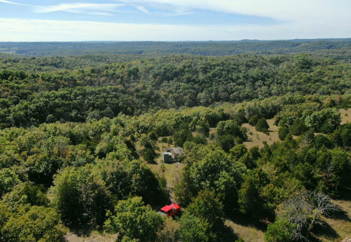
The aerial photo above (facing south from over the north side of the property) shows part of the glade on the north side of the property where the remains of the old cabin are located.
Feel free to check out the property but bring a bottle of water if you plan on walking down to the south side of this tract as it is fairly steep.
Why not invest your money in something your family can use and enjoy? Take your family camping on your own property next weekend!
It is VERY rare to find a property with this kind of view AND with good access! Although the gravel road is generally in fairly good shape it does sometimes get rutted so a truck or an SUV would be ideal to access this property.

Parked on the property.
This property offers an open glade area, mature timber, privacy and views for miles.
The sales price on this 8 acre tract is $32,500. With $500 down the monthly payments will be $340. This is about a 15 year payment schedule and an annual interest rate of 9 3/4%. With $1,500 down the interest rate drops to 7 3/4% and the payment drops to $295 a month. With $2,500 down the interest rate drops to 6 3/4% and the payment drops to $270 a month. With $5,000 down the interest rate drops to 5 3/4% and the payment drops to $230 a month. These payments are all based on about a 15 year payment schedule. Property taxes willonly be about $65 a year and are current. There are no prepayment penalties, no hidden fees and no balloon payments.
PLEASE NOTE that you have a full 12 months to ADD to your down payment in order to reduce your interest rate and payment amount!
If this is the property for you then please choose your initial down payment amount in the box below and you may pay with any debit or credit card. Also please feel free to send us an email or give us a call and we can answer any questions or complete the transaction over the phone. Our number in the office is 417-882-3400 or you can reach us anytime by email at [email protected].


