SORRY, THIS PROPERTY HAS BEEN SOLD!
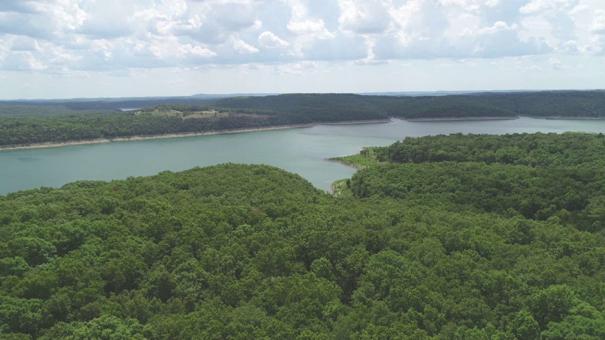
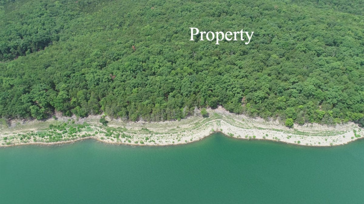
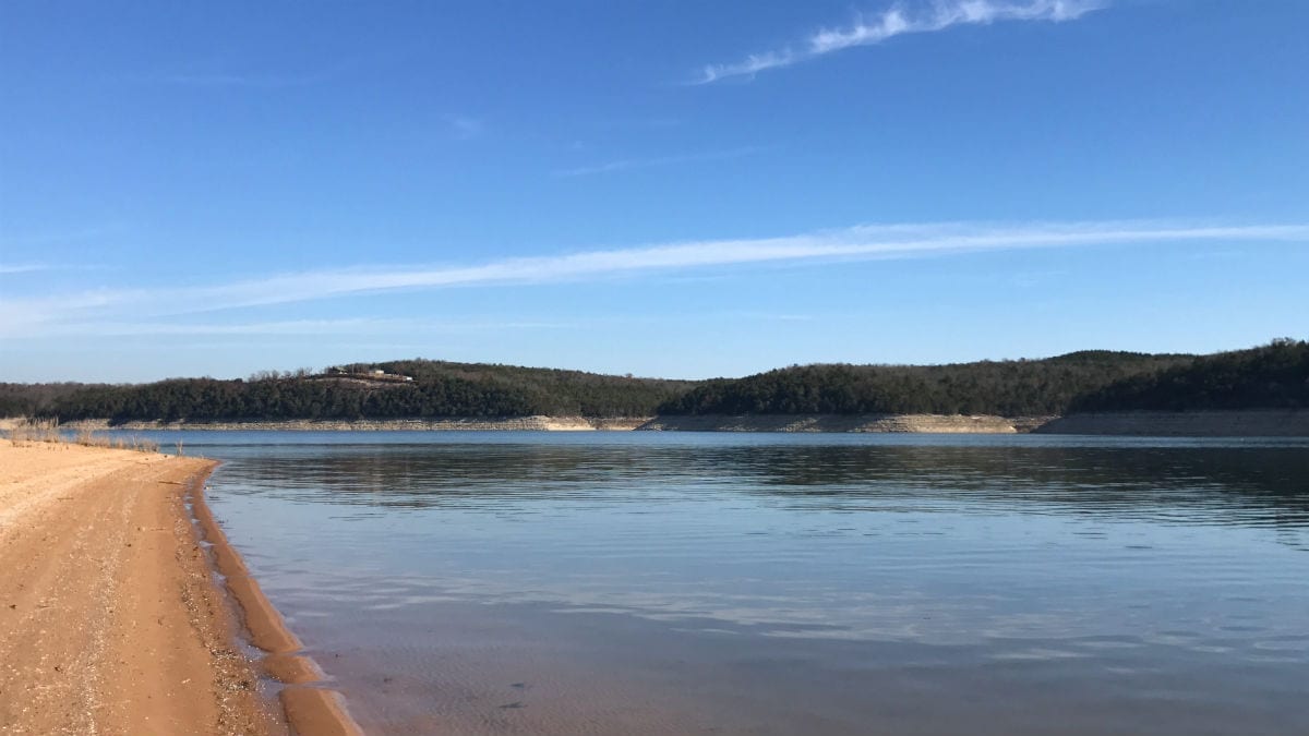
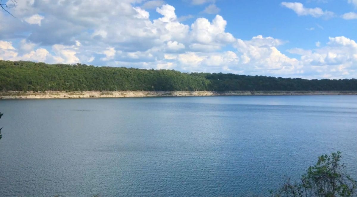
In the aerial photo above we are looking over the property toward the main channel of Bull Shoals Lake.
Stunning property with nice timber (both hardwoods and cedars) and about 180 feet of direct frontage on the Corp Of Engineers “Take Line” at Bull Shoals Lake. A large 3.205 acre tract at the very popular Bull Shoals Lake about 30 miles from Branson, Missouri.
With about 180 feet of frontage on the “Take Line” at Bull Shoals Lake, you can walk directly from your property through the Corp Of Engineers land right to the water. Fish from the shore and fry up your catch on your own campfire. You can also hunt in the Corp Of Engineers land which gives you hundreds of acres of additional hunting land adjacent to your property!
This 3.205 acre tract is located within an exclusive area called “Timber Shoals Ranch” on Bull Shoals Lake. This tract is a sportsman’s dream sitting on a private peninsula on Bull Shoals Lake.
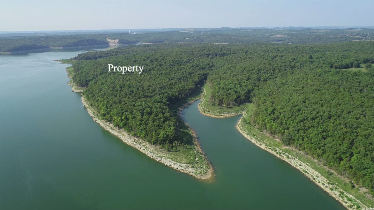
This special tract happens to be located at the southeast side of the private peninsula at Timber Shoals Ranch, in a private section called “Walleye Shores at Timber Shoals Ranch”. The few tracts at “Walleye Shores” offer very easy access to the shoreline because the property slopes so gently to the water through the Corp Land. The tracts also are adjacent to a long trail which goes through the Corp Land all the way to the tip of the little peninsula which you can see in the photo above. – Special property in a special area!

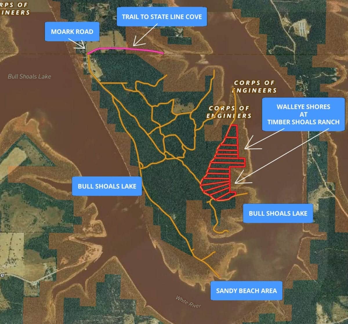
The map above shows “Walleye Shores at Timber Shoals Ranch” which is a secluded area of only 14 tracts at the southeast side of Timber Shoals Ranch. The tracts at Walleye Shores offer maximum privacy as well as gentle access to the shoreline of Bull Shoals Lake.
We have found at least two natural access points to the water at Timber Shoals Ranch where we have put a boat into the water (there are probably more access points that have not yet been discovered). State Line Cove (about a mile north of the property) is one access point where we have launched a pontoon boat and there is another access point at the very south end of the peninsula at the “Sandy Beach Area”, where we have also launched a pontoon boat and jet-skis.
This stunning property provides outstanding whitetail deer hunting, turkey hunting and world class fishing! This tract may be suited to an upscale homesite, a private and secluded cabin or just a place to come to camp and hunt for a few weeks out of the year.
This tract has Property Covenants in place to protect your investment (you can see them in detail farther down in this listing).
Properties with access to a major lake have for years been one of the best choices for investment as well as enjoyment.
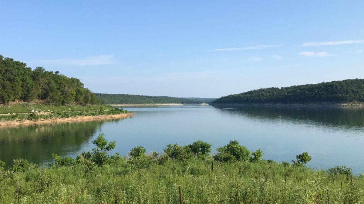
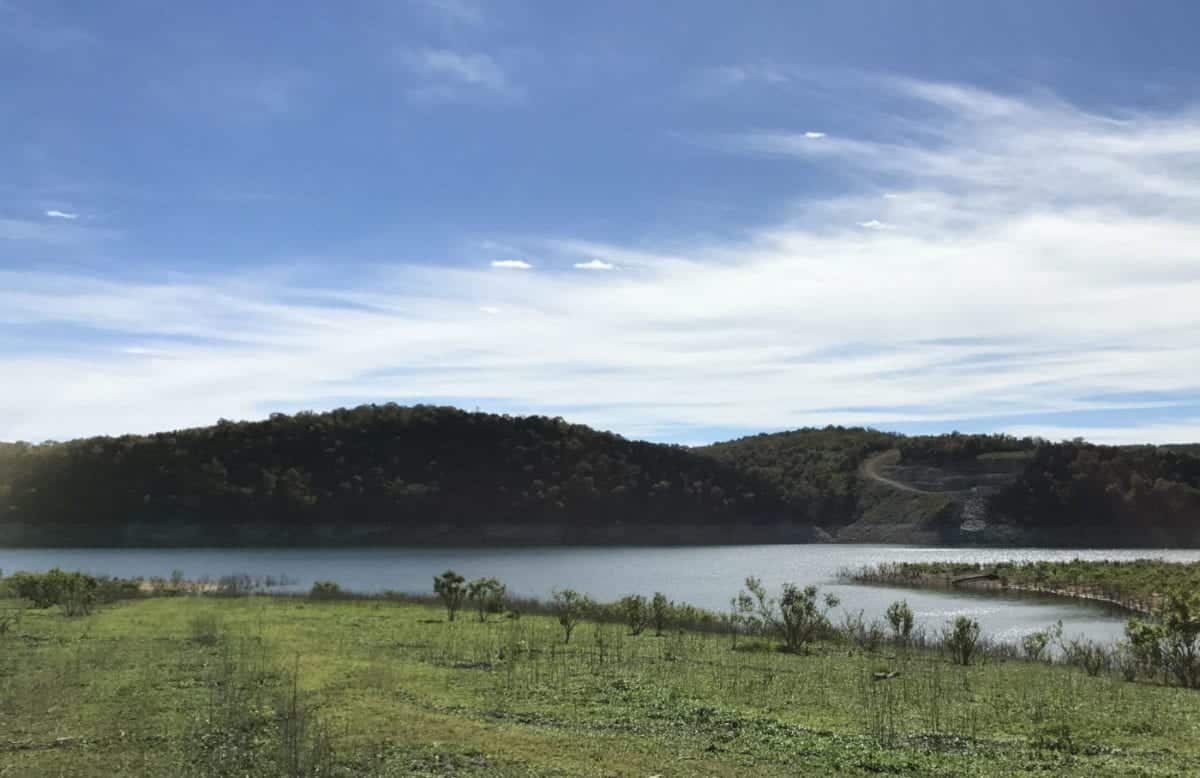
The photo above shows a great view of the lake from the Corp Land which is connected to the property. This photo was taken at the end of the long trail which runs all the way to the tip of the peninsula that you saw in the second photo in this listing.
The full sales price for this 3.205 acre tract at Walleye Shores is $36,500. With your $1,500 down payment you will automatically get out reduced annual interest rate of 7 3/4% and your monthly payments will be $355.
With a $2,500 down payment the interest rate drops to 6 3/4% and the payment drops to $330 a month. With $5,000 down the interest rate drops to 5 3/4% and the payment drops to $290 a month. These payments are all based on about a 15 year payment schedule. Property taxes & maintenance fees (for the easement roads) will only be about $300 a year and this is already included in the monthly payment amounts. There are no prepayment penalties and no hidden fees.
PLEASE NOTE that you have a full 12 months to ADD to your down payment in order to reduce your interest rate and payment amount! We want to give ALL of our buyers the opportunity to achieve the lowest interest rate and payment amount possible!
ALSO, if you decide to pay off your property (your loan to us) at any time within the next 5 years you will get a 10% DISCOUNT off of the balance owed at the time of payoff – on this property that would be a savings of $3,650!
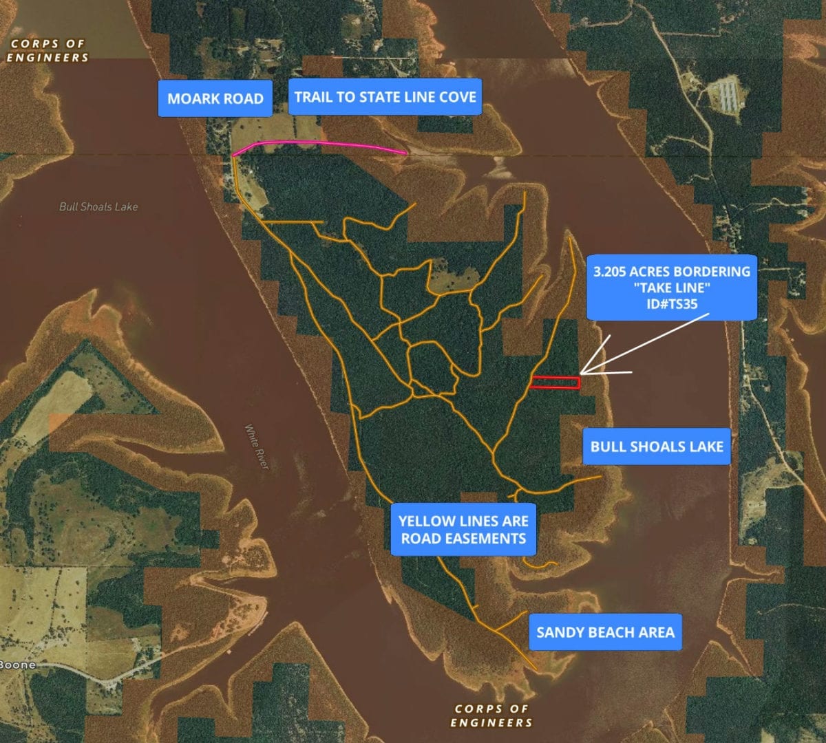
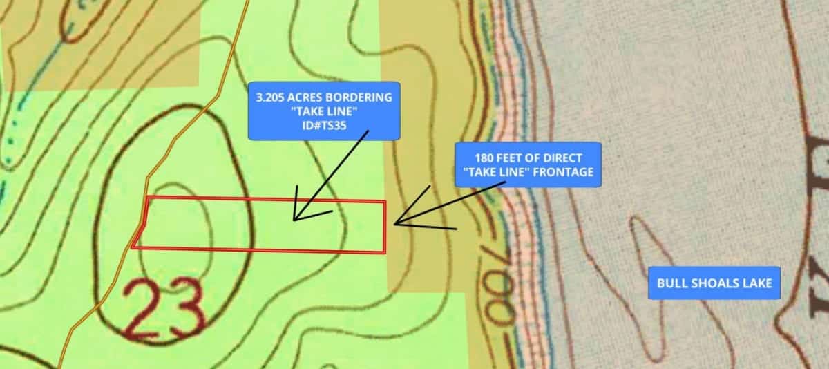
The map above shows the entire peninsula of Timber Shoals Ranch. “Walleye Shores” would be the southeast side of the peninsula, where you will find this property. The 3.205 acres is outlined in red in the photo. The “brownish” shaded area is the Corp Of Engineers land around Bull Shoals Lake. The yellow lines are the easement roads/trails within Timber Shoals Ranch. The private peninsula has over 5 miles of shoreline, of which we have explored very little. The south side of the peninsula is where we found the “Sandy Beach Area”. The land slopes gently into the water by this sandy beach and it is an awesome place to spend the day. The pink line on the map above is a trail to State Line Cove on Bull Shoals Lake which is another place we have launched boats/jet skis.
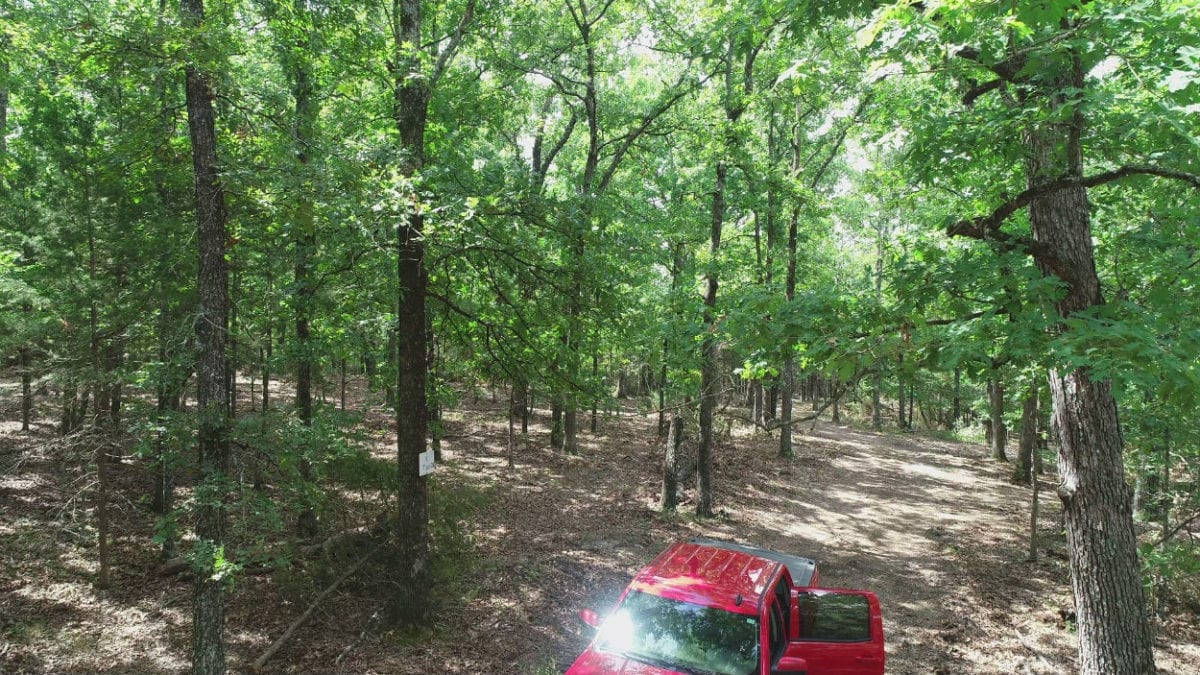
We are parked at the property in the above photo. Very level tract with nice mature timber.
We have several videos of this breath-taking property. In the video below, we check out the property with our drone:

$500 Down with 180' frontage - Stunning 3.2 acres at Bull Shoals Lake - Owner Financing - ID#TS35
Power and phone are at the north end of Timber Shoals Ranch so they are within about a mile of the property. Utility easements are in place for the power/phone to be run to the property if/when you need them. Water would be by drilled well and sewer would be by septic tank or holding tank. We generally have fairly good cell service at Timber Shoals Ranch and the wifi in our truck generally works as well.
The property DIRECTLY borders the “Take Line” at Bull Shoals Lake along its entire east side. This area is renowned for its bass fishing, so much so that the B.A.S.S. Elite Series tournament was held right here in 2016! Huge walleye, catfish and many other types of fish can also be found in Bull Shoals Lake. You can fish this lake year around giving you unlimited fishing opportunities.
In the video below, we check out the property from the ground starting on Moark Road at the north end of the peninsula. This is a REALLY long video but it does a good job showing the drive to the property. If you want to see just the property itself you can skip to the last several minutes of the video:
Video Ground TS35 DONE
In the video below, we check out Corp Land toward the end of the trail which runs north past the property and all the way to the tip of the smaller peninsula:

Video Corp Land At The End Of The Peninsula at Walleye Shores - www.InstantAcres.com
The video below is an “Introduction” to the property and the area. This video has a ton of information about the property itself as well as the area. We are using the “MapRight” interactive map in this video (you will find the actual interactive map later in this listing):

Video Intro TS35
In the short video below, we check out the private cove which is to the north of the property:

Fun video showing a few fish in the cove next to the property - www.InstantAcres.com - ID#TS
In the video below, we take the trail (which is about a mile north of the property and can be seen as the pink line on our maps) to State Line Cove. We also find a few wild turkeys:

The trail to State Line Cove (plus wild turkeys!) on Bull Shoals Lake
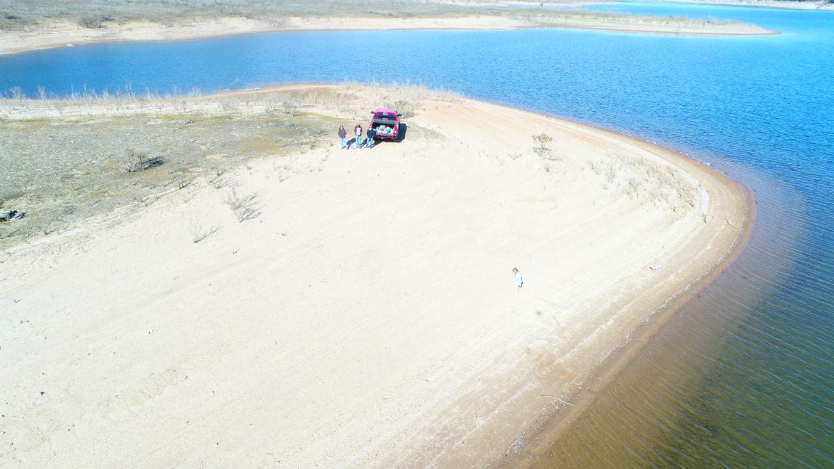
The photo above shows one area at the south end of the peninsula where you can potentially put your boat right into the water. When the water level is low you can enjoy a huge amount of very rare, sandy shoreline! Even when the water level is high you can fish right from the bank and possibly launch your boat or a jet ski.
Although the property is private and secluded you can get to Branson, Missouri in about 45 minutes. Springfield, Missouri (where our office is located) is a little over an hour to the north.
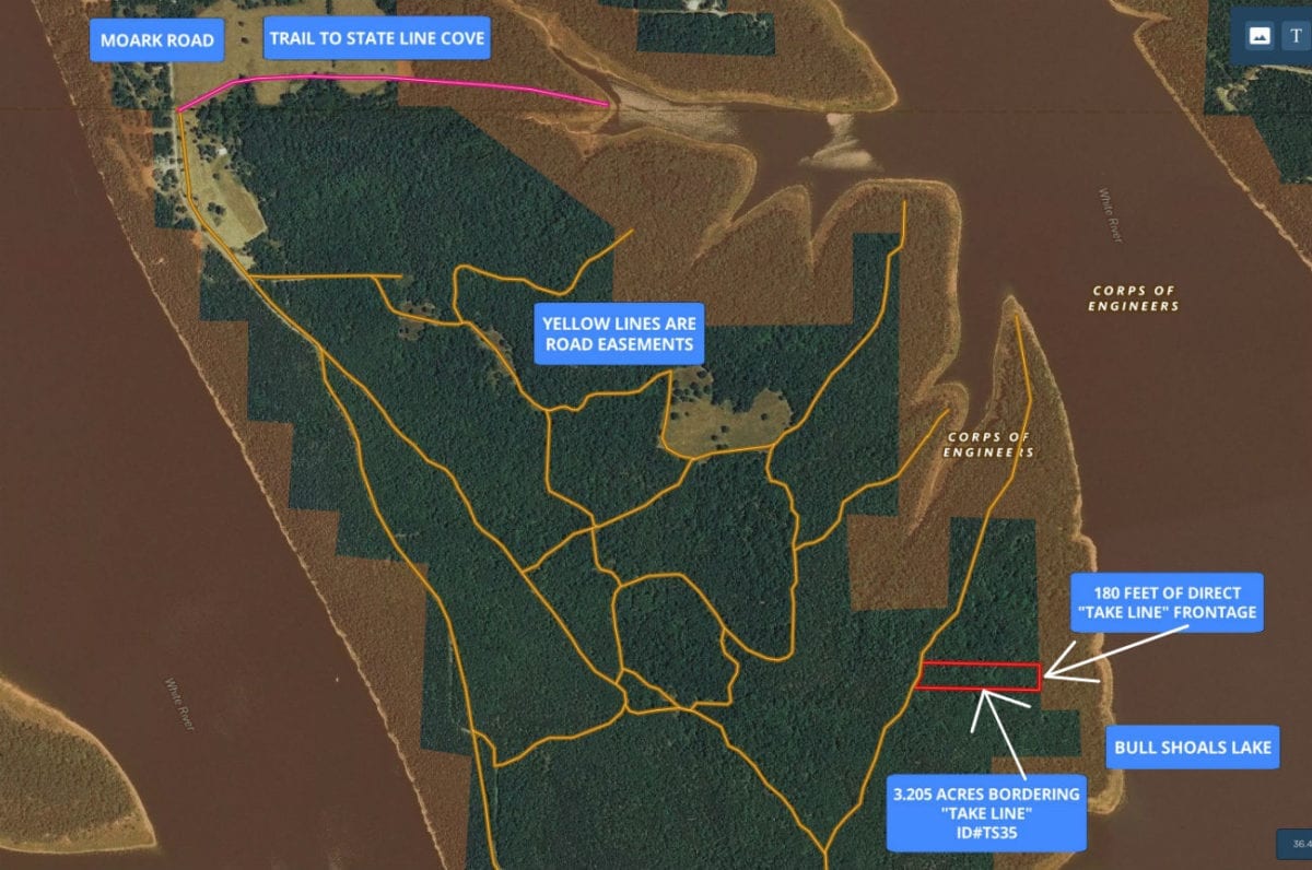
The pink line at the top of the map above is the trail which will take you to State Line Cove, to the north of the property. This is a rough trail but it is has been a handy place for us to put jet-skis into the water. The aerial photo above shows how the property is situated. Bull Shoals Lake is a “Corp of Engineers” lake which means it was created and is maintained by the Army Corp of Engineers. On all “Corp of Engineers” lakes, the water itself as well as a buffer area around the water is actually owned/controlled by the Corp of Engineers. As a property owner with frontage on the Corp Of Engineers Line, you are able to use this additional land for hunting and recreation as well as to cross over in order to access the water. As no private individuals own the actual water on Bull Shoals Lake, a property that has frontage on the Government “Take Line” in generally considered lakefront. On the map above, the red area (outlined) is the property and the shaded area (brown) is the Corp of Engineers land which is what gives you the access to the water. From the east side of this property you can walk a very short distance to get right to the lake and enjoy a huge amount of shoreline.
Because the Corp Of Engineers Land is also open for hunting, you actually have direct access to several hundred acres of additional hunting land which directly adjoin your property!
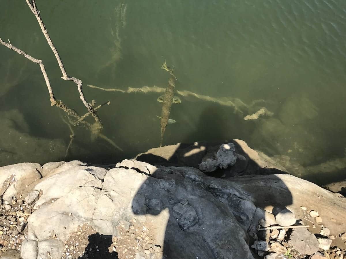
In the photo above we are down at the small cove (north of the property). You can see a large fish in the water – this area of Bull Shoals is renowned for its amazing fishing!
Timber Shoals Ranch has a proven “track record” for numerous deer and turkey. Almost every time we visit the area we see multiple deer and often we see turkey as well.
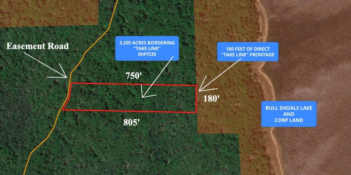
The aerial photo above gives you a “close-up” view of the property. This tract borders the private easement road along its west side and directly adjoins the Corp Of Engineers Land for about 180 feet along its entire east side. This is a huge amount of frontage on the Corp Line! This tract is almost all wooded and has not been logged for many years (except for possibly some trees cut for firewood).
This is a unique opportunity to own a trophy property with complete owner financing.
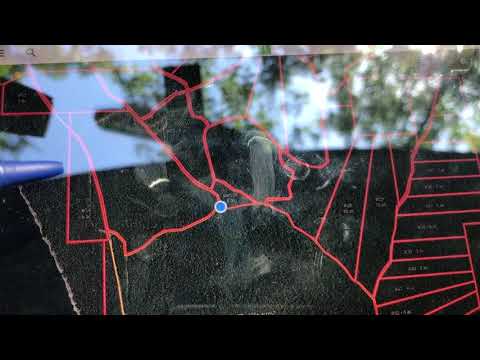
Please refer to our interactive map above for additional property views and information. The yellow lines on the map are part of the gravel easement road system running throughout Timber Shoals Ranch. These are minimum maintenance roads that are designed with a truck or an suv in mind. They will never be “highways”, which adds to the character of this secluded area. The property itself is outlined in red. Please note that the boundary lines and measurements on the interactive map are approximate. The property borders the easement road along its entire west side and it has about 180 feet of direct frontage on the “Take Line” on its east side.
The interactive map is an excellent tool to use for viewing this property. When you open the interactive map, feel free to play around with it a little bit as it has many functions/features.
To truly appreciate this property you may want to plan a visit to the area to check the property out and spend some time exploring. We can email you the direct link for the interactive map above so that you can view the map WHILE you are looking at the property. All you need to do is download the MapRight app to your smartphone or tablet (free app) and then we can email the link to your phone. The interactive map is a MUST when viewing the property as the easement road system is extensive and can be very confusing.
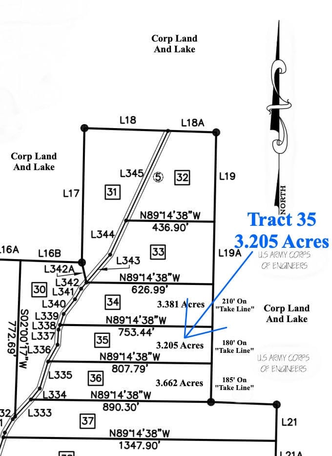
The survey map (above) shows the property which is 3.205 acres in size and directly borders the Corp Of Engineers land for 180 feet along its entire east side.
As these properties are high-quality investment grade tracts, they have similar Deed Assurances to some other upscale developments such as Fiery Fork Ridge and Riverside At The Niangua. As Timber Shoals Ranch is designed as an upscale lakeside community, these simple Deed Assurances have been designed to be minimally restrictive while still keeping your property value high.
Please click on the link below to see the Deed Assurances for Timber Shoals Ranch. If you have any questions at all, please let us know.
To see the additional property covenants at Timber Shoals Ranch please click here.
The Deed Assurances include but are not limited to:
- No mobile homes or modular homes are allowed
- No portable buildings are allowed
- No commercial activity is allowed
- Camping is allowed for a maximum of 45 days in a 12 month period.
- Residences must be on a minimum 600 square foot concrete foundation and up to two residences are allowed on each tract.
- For building/camping purposes, there is a 100 foot setback from roadways and a 10 foot setback from side boundaries.
- Please click on either the link below or the link above to see all of the property covenants
Here is the link one more time:
To see the additional property covenants at Timber Shoals Ranch please click here.
Please do click on either of the links to fully familiarize yourself with the property covenants. If these Deed Assurances do not meet with your needs, then we would be happy to be on the lookout for a property which does fully fit your needs.
Also, please note that trees with a stump diameter of more than 8 inches may not be cut, sold or disturbed until the property has been paid for in full.
We have been told that you can build you own home or cabin with no permits (600 square foot minimum foundation size). Spend a few weeks this summer and build a vacation home/cabin with your friends or family!
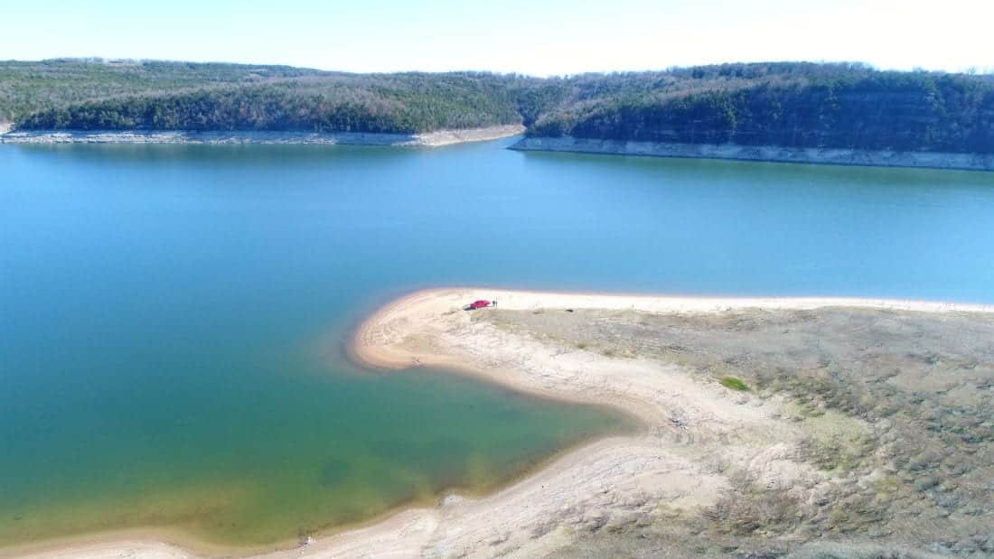
The aerial photo above was taken over the south end of the peninsula. The truck is parked in the sand right by the water. To get to this area you take the main easement road all the way to the south end if the peninsula. There are possibly other areas with sandy shoreline as well, but we have not checked out all of the water frontage on the huge peninsula.
Can you spot the little girl in the photo above? She was taking a break from fishing to run through the sand.
This is an amazing opportunity to own and use a high quality piece of real estate while watching the value rise. Generally, land with direct frontage on the “Take Line” is known to be a much safer and more profitable investment than land without “Take Line” frontage. Build your home or cabin and go fishing for your lunch and dinner!
Although the Corp Of Engineers is not currently issuing any new dock permits in the area, there are docks available for rent in the general area. It could be very convenient to store your boat right on your property and just put it into the water when you want to spend the day on the lake.
Fishing, jet skis, water skiing and tubing are all excellent here! Swimming at the sandy beach would be a fantastic way to create memories with family and friends!
We have included multiple maps, pictures and videos that show this amazing tract of land. There is a lot to see so please take your time and check it all out.
Many of the roads/trails at Timber Shoals Ranch have not been used for years and we are in the process of cleaning them up to make them more usable. Our guys are in the process of cleaning them up but the roads were designed for trucks or SUVs and will always be rustic. We feel that the private easement roads add to the “private and secluded” feeling that you will enjoy while you are on your property. As Timber Shoals Ranch encompasses an entire peninsula it is a very safe and secure environment and access is ONLY for property owners and their guests. While the Corp Of Engineers land is open to the public, there are NO public roads leading to the Corp Of Engineers land on the peninsula (only the private roads within Timber Shoals Ranch).
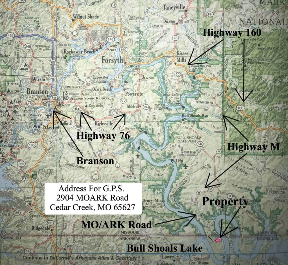
The map above is a road map which which shows the route to the property from Branson, Missouri. The property is actually only about 15 miles southeast of Branson although by road it is about 30 miles (they wind around quite a bit). If you enter the address: “2904 MOARK Road, Cedar Creek, MO 65627” into your gps/phone it should take you to the end of the paved road (MOARK Road). You will then go through the entrance area and proceed south to the property on the private easement roads. We will be happy to email you the maps if you would like as you will definitely want the maps in hand when you make your first trip to the property. Since you cross the state line about a mile before you get to the property, it is actually located in northernmost Arkansas.
To get to the property from Branson you can go east on Highway 76 until you come to Highway 160. Then go east on Highway 160 to Highway M and go south (right). Now follow Highway M all the way down to MO/ARK Road and stay on MOARK Road until it ends. Now take a left at the end of MOARK Road onto the gravel and proceed south on the gravel easement roads to the property. Look for the sign in the trees which says “Tract 35”. Email or call us before you make the trip and we can give you the combo for the lock at the start of the easement road.
You will DEFINITELY want to bring the printed maps and the MapRight app and link on your first trip as the easement roads/trails can be VERY confusing and it would be easy to get turned around or even lost on this large private peninsula!
In the aerial photo above we are over the main channel looking west toward the property. You can explore miles of shoreline and find your favorite fishing spots!
The topo map above shows how the land is situated. The property is the highest at its west side by the easement road and is slopes down very gradually as you move to the east. This is one of the most level tracts at Timber Shoals Ranch which gives you a huge amount of usable ground. Like several of the other tracts at “Walleye Shores” in Timber Shoals Ranch, this property has a very gentle slope through the Corp Land right to the water line. Well-suited for a family with small children or other family members who need gentle access to the water.
From the impressive wildlife and timber to the world class lake access and gentle terrain, this tract is amazing! This large, private, secluded, accessible and rare tract will not last long…
The photo above shows one of the beach areas which is accessible through the south end of the penninsula. This sandy beach slopes gently into the water. Ideal for families with children. You can drive a truck right to the water! Next to this sandy beach is an area with a little more gravel, which we have used for putting a boat and jet skis into the water.
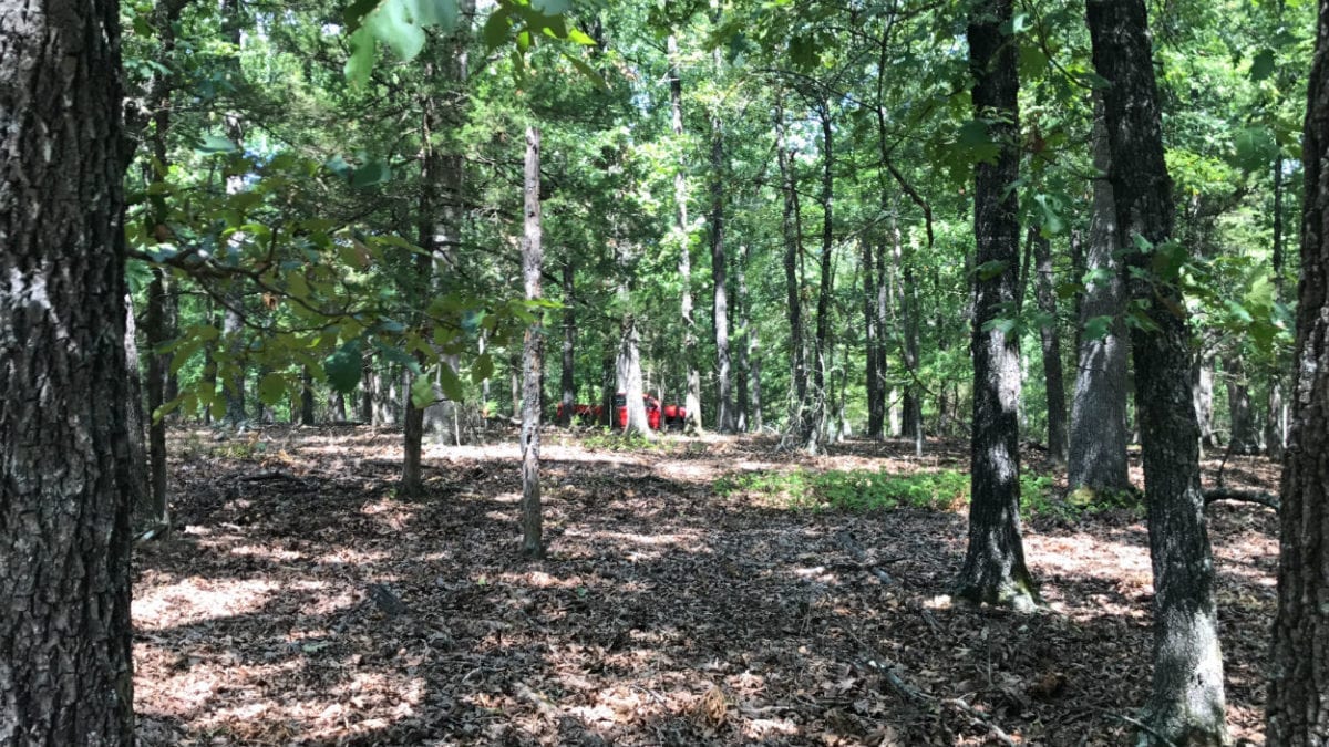
In the photo above we are standing on the property looking toward the road. Mostly level tract with good timber and numerous sites for camping, building and hunting.
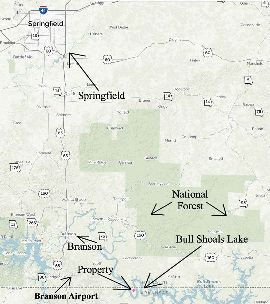
The property is located in northern Arkansas, about a mile south of the Missouri/Arkansas state line. Although you will probably have all the wildlife you need on your private acreage (as well as the Corp Of Engineers Land), you are also just a short distance from about 50,000 acres of National Forest which is available for additional hunting and recreation.
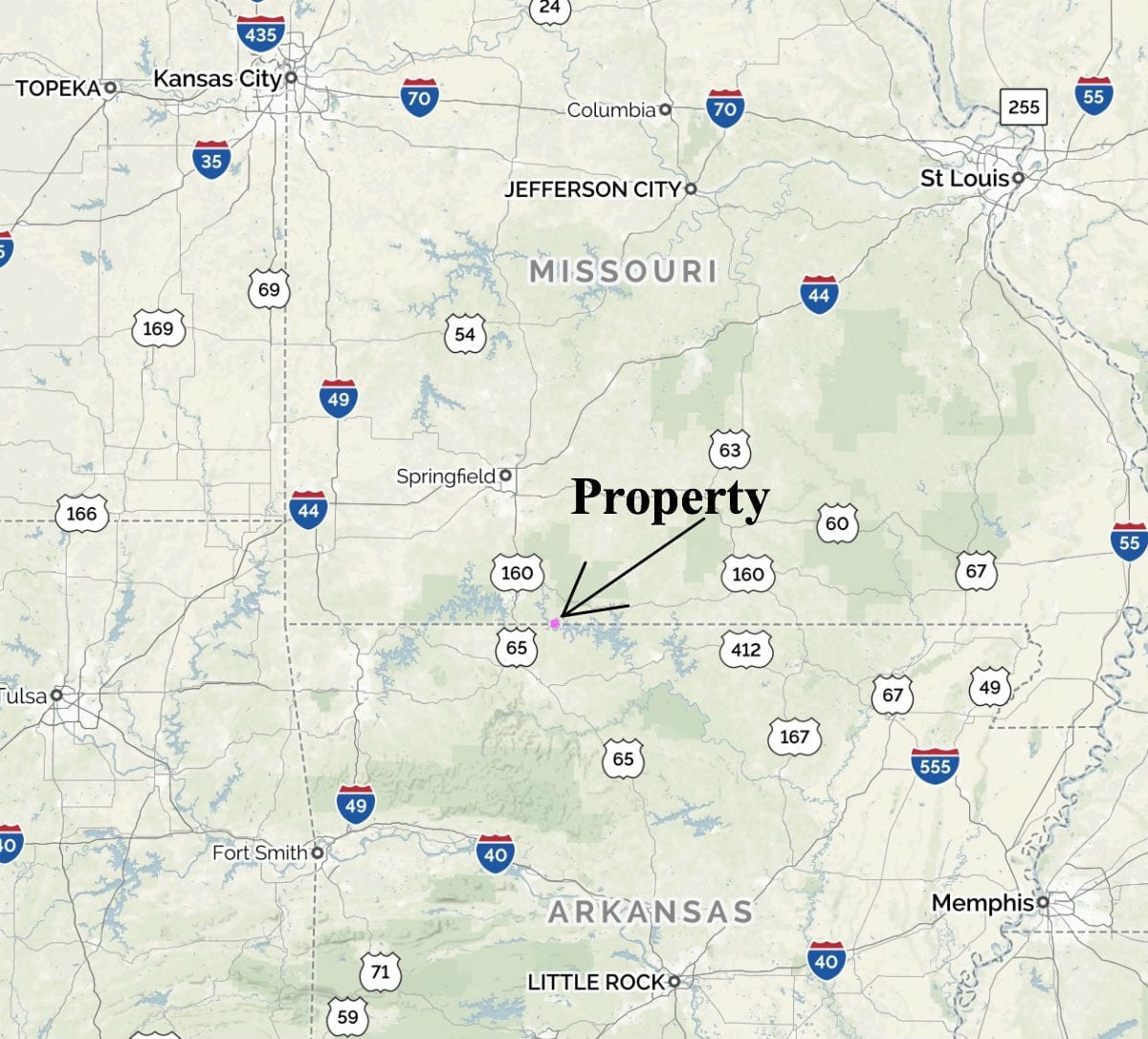
Amazing centralized location. This tract is within half-a-day’s drive to numerous large cities including St. Louis, Memphis, Little Rock, Tulsa and Kansas City. Yet it is totally private!
The photo above was taken in the Corp Of Engineers land just to the east of the property. Come and explore the miles of shoreline! You can fish all year around!
Don’t miss this incredible opportunity to own this unique property. Email us at [email protected] or call us at (417) 882-3400. We offer complete owner financing on this stunning Bull Shoals Lake property!
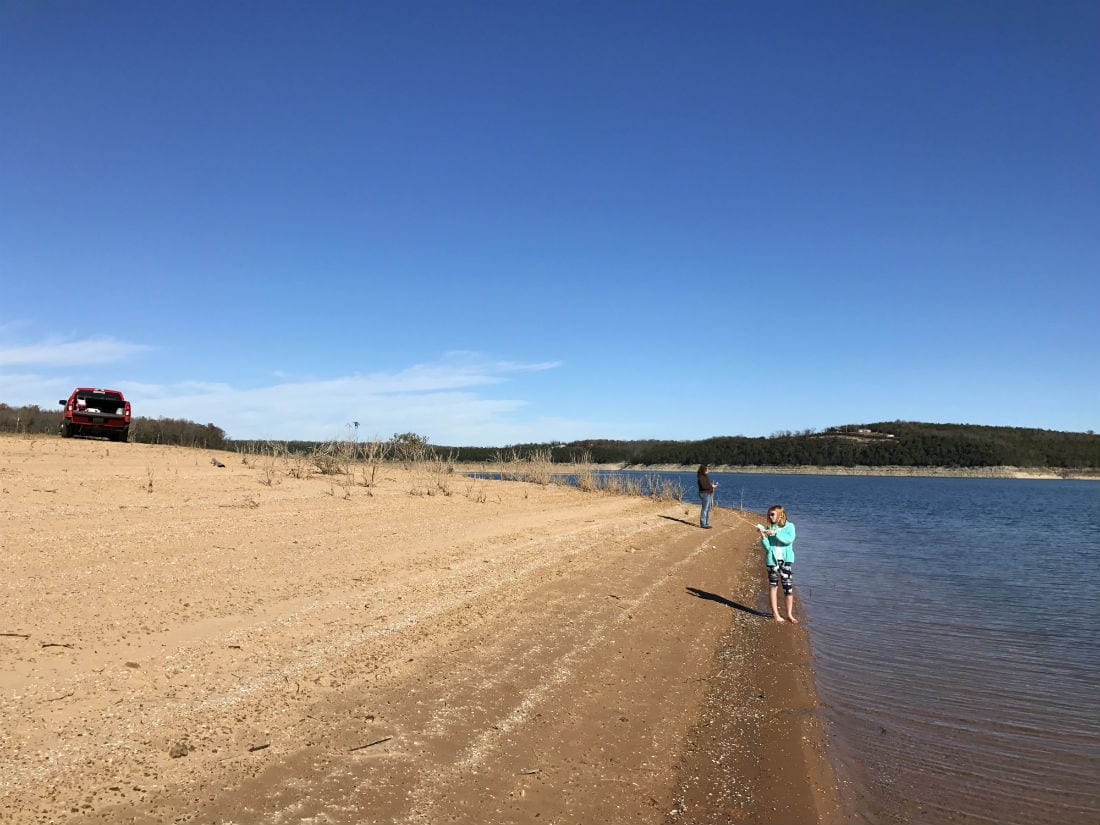
What a great way to spend your vacation! In this photo Nicole is going after some bass, from the sandy beach area at the south side of the peninsula.
The full sales price for this 3.205 acre tract at Walleye Shores is $36,500. With your $1,500 down payment you will automatically get out reduced annual interest rate of 7 3/4% and your monthly payments will be $355.
With a $2,500 down payment the interest rate drops to 6 3/4% and the payment drops to $330 a month. With $5,000 down the interest rate drops to 5 3/4% and the payment drops to $290 a month. These payments are all based on about a 15 year payment schedule. Property taxes & maintenance fees (for the easement roads) will only be about $300 a year and this is already included in the monthly payment amounts. There are no prepayment penalties and no hidden fees.
PLEASE NOTE that you have a full 12 months to ADD to your down payment in order to reduce your interest rate and payment amount! We want to give ALL of our buyers the opportunity to achieve the lowest interest rate and payment amount possible!
ALSO, if you decide to pay off your property (your loan to us) at any time within the next 5 years you will get a 10% DISCOUNT off of the balance owed at the time of payoff – on this property that would be a savings of $3,650!
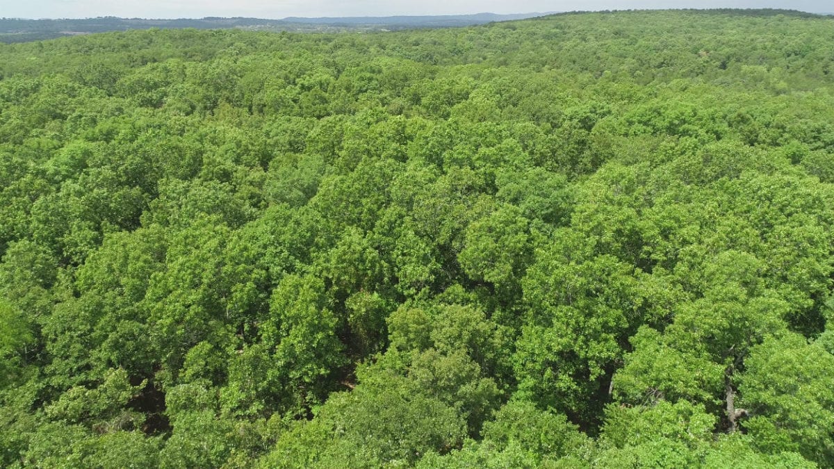
Tons of mature timber on this tract as shown in the above aerial photo.
As soon as your down payment has been received we will send out your paperwork and you are welcome to use and enjoy your new property immediately! If this is the property for you then you can select your down payment in the box on this listing page – or you can call us in the office at (417) 767-2223 or email us at [email protected].


