SORRY, THIS PROPERTY HAS BEEN SOLD!
Rare acreage at Cedar Gap Hollow with electric DIRECTLY on the property. This tract also has some beautiful mature timber as well as a private driveway and small cleared site for camping, hunting, building and more! The small creek bed in the middle of the property offers some excellent opportunities for hunting for arrowheads, fossils and cool rock formations!
This is Tract 70 at Cedar Gap Hollow in western Wright County, Missouri. It is about 35 miles east of Springfield, Missouri. This property is surveyed with the corners marked and is 5.0 acres in size.
Excellent tract at Cedar Gap Hollow South which is located toward the south of Cedar Gap Hollow. This particular tract is one of the VERY FEW tracts at Cedar Gap Hollow that has an electric line DIRECTLY ON the property, giving you easy access to power if you ever need it.
This well-located acreage is not too far from Springfield, Missouri but is still very private and rural. This acreage is located in a small Rural Development called “Cedar Gap Hollow” which is located within 3 miles of the popular “Cedar Gap Conservation Area” and only about 35 miles from Springfield, MO.
“Cedar Gap Hollow” is one of our “Homesteader Friendly Rural Developments”. This means that the standard Property Covenant requiring a minimum 600 square foot concrete foundation for a residence does NOT apply to the tracts at “Cedar Gap Hollow”. If you have been waiting for a property for your “tiny home” or for your “shipping container home” then you may have finally found what you are looking for!
PLEASE NOTE: “Cedar Gap Hollow” is accessed via private gravel easement roads. A four wheel drive is highly recommended for all tracts at Cedar Gap Hollow. A four wheel drive not only gives you much more traction, but it generally gives you more clearance than a two wheel drive vehicle, and that can be necessary on gravel easement roads.

In the winter-time aerial photo above we are looking southwesterly over the property. The white truck toward the right side of the photo is parked about halfway down the driveway on the north side of the property (gravel easement road is on right side). The small cleared site is at the end of the private driveway. As we look over the mature timber, the property slopes down to a small creek bed, and then slopes back up until it finally borders Highway 60 along its south side (in the distance).

In the aerial photo above we are looking westerly while over the south side of the property. On the far left side of the photo you can see Highway 60. Moving to the right from there, you can see the electric line which crosses directly over the south side of the property. Moving to the right (north) from there you can see the small creek bed which crosses over the property and then continuing to the right you can see how the property rises back up until you get to the north side (where you will find the private driveway and small cleared site. Having an electric line on your property tends to greatly improve its value (even if you don’t plan to ever hook into it).

Cedar Gap Hollow South is an area of about 20 tracts located toward the south side of Cedar Gap Hollow (as shown on the map above). Since these tracts are located toward the south side of this rural development, they tend to have better access to Highway 60 than many of the other tracts within the development. This listing is for Tract 70 which is 5.0 acres in size and is located on the left side of the aerial photo above.
You will notice on the aerial map above that Tract 70 appears to have direct frontage on Highway 60. While the south end of Tract 70 does border the north side of the Highway right-of-way, you would not be able to access the property off of Highway 60 because there is not driveway or approach (and you would not be able to install one as the highway department would not permit it). The access to this property is via the gravel easement roads within Cedar Gap Hollow, which will take you to the north end of this tract.

The map above shows the “Cedar Gap Conservation Area” which is less than two miles south of the tracts at Cedar Gap Hollow. Springfield, Missouri is about 35 miles to the west.

The little town of Seymour, Missouri is about 5 miles west of these properties. Seymour has a wonderful “small town” feel and offers several restaurants and gas stations.
PLEASE NOTE: Because we do offer a “Trade Policy” on the tracts sold through our website, and because we do sometimes lease tracts for a period of several weeks/months, it is possible that this tract was either sold and/or leased prior to this listing. Although we do try to provide current pictures/videos of all properties, we are not generally able to inspect all individual properties prior to offering them for resale (in the event that they had already been sold or leased). We always recommend that you make a personal visit to an available property before making a down payment, as it is possible that a previous owner or renter has left debris/supplies/stuff behind on the property when it was vacated.
The hunting and wildlife watching opportunities in this area are EXCELLENT with a large population of white-tailed deer as well as wild turkey. This property could also be suitable for off-grid building, homesteading, camping and recreation.
The full sales price for this 5.0 acre tract at Cedar Gap Hollow with private driveway, cleared site and electric is $46,500 and we offer INSTANT owner financing with just $1,500 down.
With your $1,500 down payment you will automatically get our reduced interest rate of 7 3/4% and your monthly payment will be $458.58.
With a $2,500 down payment the interest rate drops to 6 3/4% and the payment drops to $424.37 a month. With a $5,000 down payment the interest rate drops to 5 3/4% and the payment drops to $379.63 a month. These payments are all based on about a 15 year payment schedule. Property taxes & road maintenance fees total only $35 a month and this is already included in the monthly payment amount. There are NO prepayment penalties and NO hidden fees.
PLEASE NOTE that you have a TWELVE MONTHS to ADD to your down payment in order to reduce your interest rate and payment amount! We want to give ALL of our buyers the opportunity to achieve the lowest interest rate and payment amount possible!
ALSO, if you pay off your property (your loan to us) at any time within the next 5 years you will get a 10% DISCOUNT off of the purchase price of the property! On this property that would save you $4,650 for an early payoff!
The Tracts at Cedar Gap Hollow are sold through our partner company which is Regions Land Company. The sales process is the same as you see on the InstantAcres website, but the paperwork will shows Regions Land Company as the “seller”.

The aerial photo above was taken while facing southeasterly over the north side of the property. The white truck has pulled about halfway down the private driveway and is almost to the small cleared/leveled site on the property. Although there is already a private driveway/cleared site on this tract, it also offers other areas that could be usable for building and camping or creating trails. Please keep in mind you must be 100 feet off of the centerline of the easement road for camping, parking, storage, building, etc.
The photo below is a close-up of the survey map which shows this property (Tract 70, which is toward lower left side of the map). This property is 5.0 acres in size. It borders the gravel easement road along its entire north side and it borders the “right-of-way” for Highway 60 along its south side.

The maps below show an approximation of the boundaries of the property. For the precise boundaries please refer to the survey map above.

The winter-time aerial map above shows how this tract is situated. It borders the private easement road along its north side and it borders the “right-of-way” for Highway 60 along its south side. The small creek bed crosses over the middle of the property and the electric line crosses over the south side of the property. If you look closely at the aerial photo above, you will notice that there appears to be a smaller creek bed which feeds into the larger creek bed toward the east side of the property.
This property is the highest toward its north side. As you move southerly from the gravel easement road the property stays fairly level for about 150 feet, it then slopes down as you move toward the creek bed in the middle of the property. After you cross over the creek bed, the property stays level for a little while and then slopes back up as you move toward the south side.

The topo map above gives you an idea of the “lay of the land”. Topo maps can be confusing so be sure to check out the drone video (and other videos) in this listing, which will help to show how the land is situated.
Please Note: Because this tract (as well as a few other tracts) border the “right-of-way” of Highway 60, there is an existing “billboard easement” on the south 100 feet of the properties. There is no billboard in place (and there may never be any billboard in place) but we wanted to make everyone aware of the easement. The “billboard easement” only applies to the south 100 feet of the property. You would not be responsible for the maintenance of any billboard that was ever placed within the 100 foot easement. On this particular tract (Tract 70) the billboard easement does not appear to make much of a difference at all to the property – because the power line runs over the southern portion of the property, you would generally not have room to build within the south 100 feet anyway (since you would likely be within the easement for the existing power line). Also, the south side of the this tract slopes down steeply as you go north from Highway 60, making the southern-most side a poor choice for building a home/cabin. The survey map below shows the location of the “billboard easement”:

The photo above shows the location of the “billboard easement” on the south 100 feet of Tracts 69-72. On this particular tract (Tract 70), the south 100 feet would likely not be usable for building anyway, because of the existing electric line and the steep downward slope. The billboard easement does NOT limit your ability to use the electric line on the property. If you have any questions about the billboard easement please contact us.
Let’s watch some videos!!
To see a drone video of this property please click on the video below:

CG70 Video Drone CG70 2022 Narrated
To watch an “Introduction” video please click on the link below:

CG70 Video Intro CG70 2022
To watch a short “winter time” ground video of the property please click on the video below:

CG70 Video Ground CG70 2022 Done
This property is located in one of the most desirable areas of the Ozarks. “Cedar Gap Hollow” is located in westernmost Wright County, Missouri. This area has a PROVEN track record of a large and active deer population AND is within a short driving distance to Springfield (which is the largest and most popular city in southern Missouri).
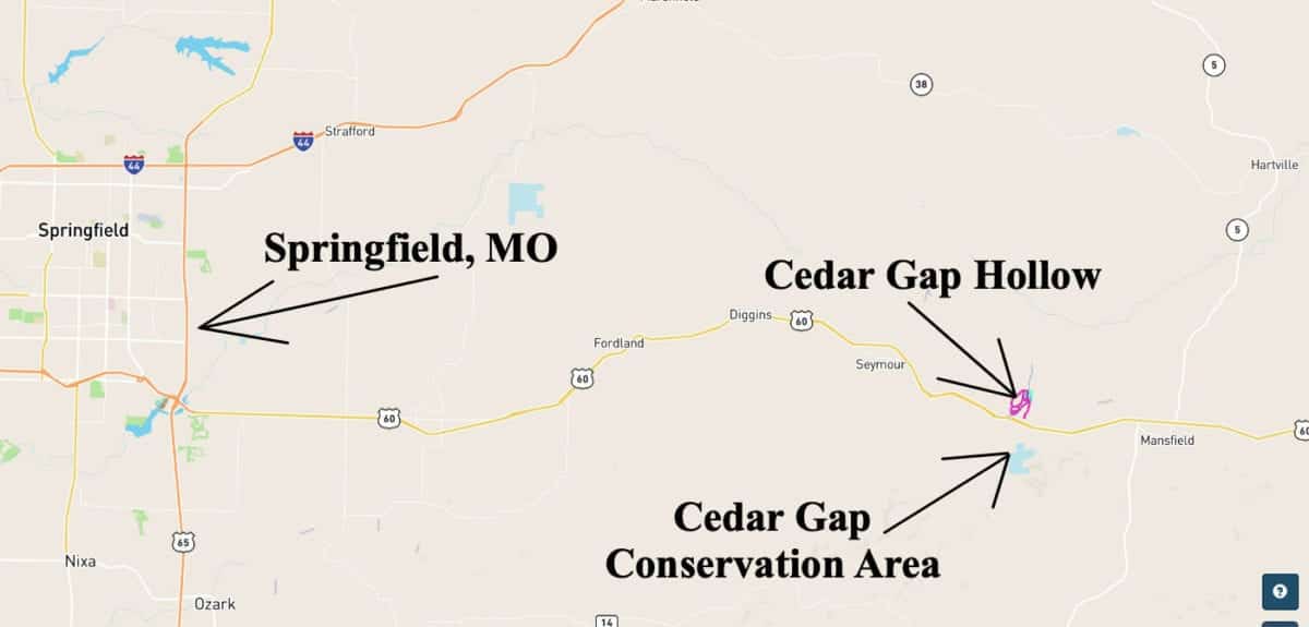 The map above shows the property’s location, relative to Springfield, Missouri (which is about 35 miles west of the property). The property is also within just a few miles of several small towns including Seymour, Missouri and Mansfield, Missouri.
The “Cedar Gap Conservation Area” can be found just a short distance to the south of this property (roughly two miles to the south). The Conservation Area is generally open for public use including hunting and hiking. You can set up your camp/cabin on your private tract and also have use of hundreds of acres in the Conservation Area!
 The map above shows the “Cedar Gap Conservation Area” which is less than two miles south of Cedar Gap Hollow.
If you would like to learn more above the Conservation Area, you can click on the link below:
Click Here for more info on the Cedar Gap Conservation Area
Within just a few miles of the property you will find several small towns, as well as some great rivers and creeks. You are also within driving distance of the Mark Twain National Forest which gives you literally thousands of acres of additional land for hunting, trail riding and recreation.
The interactive map below is a great way to explore the property and the area, right from your home. You can zoom in, zoom out and even select different “base layers” to show the roads and areas in or around the property. You can zoom in and out by clicking on the “+” or “-” buttons on the right side of the interactive map:
The map above was created with a program called “MapRight”. The property boundaries are only approximate but this map should be very helpful for exploring the property. This property has been surveyed with the corners marked by the surveyors, so MapRight would likely be helpful if you attempt to find the survey stakes.
To watch a short video about how to use the free MapRight App to locate and explore your property, please click on the link below:
Click Here for more Information on the Free MapRight App
This particular tract is located in a section of Cedar Gap Hollow which is known as “Cedar Gap Hollow South”. The tracts within Cedar Gap Hollow South are excellent for hunting. We had placed several “game-cams” on some of the tracts within Cedar Gap Hollow South (and in several spots throughout Cedar Gap Hollow) and we got numerous photos of multiple deer including quite a few large bucks. We also got photos of a large number of wild turkeys as well as some mischievous raccoons! Cedar Gap Hollow south is currently the only section of Cedar Gap Hollow that already has electric line(s) on site. This means that if you require electric it would generally be less expensive to have it run to a tract within Cedar Gap Hollow South.
This particular tract (Tract 70) is one of the very few tracts that already has an electric line running DIRECTLY across the property!
DIRECTIONS: To get to the property from Springfield, Missouri just go east on Highway 60 from about 30 miles to the town of Seymour. Now continue heading east on Highway 60 for about 5 miles and look for the road going north off of Highway 60 which is called “Connector Road”. As a landmark, you will see “Highway O” going south and this is where you will go NORTH onto the “Connector Road”. Go north for about 1/8 of a mile on the “Connector Road” and then the gravel easement road will begin (go straight at the “T” onto the gravel roadway. Take the gravel easement road northerly, then once you cross over the small creek bed you will turn left onto the other gravel easement road, which will lead you to the north side of the property.
If you are unable to download the free “MapRight” app and get it set up, then please be sure to print out the maps/directions from this listing page when you visit the property. Even with the “MapRight” app, it is an excellent idea to have the printed maps in hand when you make the trip.
We will be happy to help you get set up with MapRight and we would also be happy to email the maps/directions to you. Please contact us before making the trip to the property as there may be a locked cable/gate toward the start of the easement road. We will be happy to provide you with the combo for the lock.
Property within an hour of Springfield has been an excellent investment over the last several decades. As Springfield continues to grow the demand for tracts in this area continues to grow at a rapid rate. Lock in your property now, while you still can!
What can you do on your new property at Cedar Gap Hollow?
Although this tract is close to Springfield, it is NOT subject to the zoning regulations that you will find in the immediate Springfield area! This property is within a Rural Development and does have basic property covenants BUT almost all of our buyers find that these covenants simply do NOT limit what they plan to do with their property!
On your property at Cedar Gap Hollow you can:
- Hunt
- Camp
- Build a cabin or a home
- Homestead
- Live “off-grid”
- Have a large garden
- Have animals (no kennels greater than 5 dogs)
On your property at Cedar Gap Hollow you can not:
- No commercial businesses (other than a home business)
- No cutting of the timber until the property has been paid for in full (we can often make written exceptions for clearing a building site or driveway)
- No junkyards of any kind
To see the full property covenants please click on the link below:
Cedar Gap Hollow Property Covenants
All of the tracts at Cedar Gap Hollow have setback distances from the easement road(s). These setback areas are also designated utility easements so that all owners shall have the option of electric service. All buildings, homesites, parking areas, storage areas, etc. must be at least 100 feet from the centerline of the easement road (this area acts as a privacy setback as well as a utility easement).
Fences/gates may not be placed within 50 feet of the centerline of the easement road(s) as this area is a designated road easement area. Although there is a 30 foot setback for building/storage from the sides and rear of each tract you CAN fence directly up to the sides and rear of each tract (so long as the fence is not within the road easement).

In the photo above we are checking out the small cleared site toward the north side of the property. It is not a large site but it does give you a convenient place to get off of the easement road and park your truck/RV. This photo was taken right after the site was created. Within a couple of years it will likely have grown some nice grass (although if you spread grass seed, that would really speed up the process).

In the aerial photo above we are looking down toward the little creek bed which crosses over the property. Although it is not a “year around” creek, it often does have water (or at least some pools of water) in it. The day this photo was taken it had crystal clear water flowing through the creek bed. This photo also shows some of the beautiful mature time toward the middle of the property. Toward the lower-right side of the photo above, you can see the other small gravel creek bed which feeds into the main creek bed on the east side of the property.
This tract represents an excellent opportunity for building your own off-grid home or cabin as there are no building permits required in this area! You and your friends/family can build your own cabin without permits or inspections.

In the aerial photo above we are looking northerly while hovering over the middle of the property. Toward the bottom of the photo you can see the little creek bed and toward the top of the photo you can see that white truck which is parked on the private driveway on the property. Although most of the tracts at Cedar Gap Hollow were logged a few years ago, the majority of this tract appears to be covered in large, mature timber.
The full sales price for this 5.0 acre tract at Cedar Gap Hollow with private driveway, cleared site and electric is $46,500 and we offer INSTANT owner financing with just $1,500 down.
With your $1,500 down payment you will automatically get our reduced interest rate of 7 3/4% and your monthly payment will be $458.58.
With a $2,500 down payment the interest rate drops to 6 3/4% and the payment drops to $424.37 a month. With a $5,000 down payment the interest rate drops to 5 3/4% and the payment drops to $379.63 a month. These payments are all based on about a 15 year payment schedule. Property taxes & road maintenance fees total only $35 a month and this is already included in the monthly payment amount. There are NO prepayment penalties and NO hidden fees.
PLEASE NOTE that you have a TWELVE MONTHS to ADD to your down payment in order to reduce your interest rate and payment amount! We want to give ALL of our buyers the opportunity to achieve the lowest interest rate and payment amount possible!
ALSO, if you pay off your property (your loan to us) at any time within the next 5 years you will get a 10% DISCOUNT off of the purchase price of the property! On this property that would save you $4,650 for an early payoff!
If this is the property for you then please choose your initial down payment amount in the box below (if it is still available) and you can pay with a debit or credit card. Also please feel free to send us an email or give us a call and we can answer any questions or complete the transaction over the phone. Our number in the office is (417) 767-2223 or you can reach us by email at [email protected].


