SORRY, THIS PROPERTY HAS BEEN SOLD!
13.748 acres of wooded privacy. This property has road access, a beautiful mixture of timber and we recently discovered a private trail/driveway that leads to a private cleared area on the property.
Please click on the photos on the right side of the screen to enlarge them and to get a short description of each photo (if you are on a smartphone then the photos will be at the bottom of this listing). Farther down in this listing, you will find an interactive map, as well as a couple of videos and numerous pictures and maps.

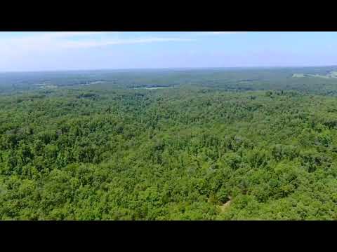
The aerial photo above shows a “birds-eye” view of the property. Cedar trees as well as hardwood trees can be found covering the land. We are over the south end of the property and we are looking to the north.
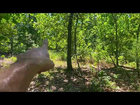
This very private acreage may be suitable for a hunting camp, vacation spot or possibly even to build a home or a cabin. Electric is not on the property but it is within about 1/2 a mile. Originally, we did not think there was any type of driveway into this private tract but when we were taking the “ground video” of the property we discovered what appears to be a long private driveway that leads to a private clearing deep within the property. If you watch the videos further down in this listing page you will see the driveway and clearing that we discovered.
TERMS OF SALE
The full sales price for this 13.748 acre tract with privacy, timber, and private driveway with cleared site is $54,500 and we offer INSTANT owner financing with just a $1,500 down payment.
With your $1,500 down payment you will automatically receive our reduced annual interest rate of 7 3/4% and the monthly payments will be $508.88. This is about a 15 year payment schedule.
With a $2,500 down payment the annual interest rate drops to 6 3/4% and the payment drops to $470.16 a month. With a $5,000 down payment the annual interest rate drops to 5 3/4% and the payment drops to $421.06 a month. These payments are all based on about a 15 year payment schedule.
Property taxes are only about $120 a year and are already included in the monthly payments shown above. There are NO hidden fees and NO prepayment penalties.
PLEASE NOTE that you have a full 12 months to ADD to your down payment in order to reduce your interest rate and payment amount! We want to give ALL of our buyers the opportunity to achieve the lowest interest rate and payment amount possible!
ALSO, if you decide to pay off your property (your loan to us) at any time within the next 5 years you will get a DISCOUNT in the amount of 10% of the purchase price of the property! On this property that would save you $5,450 for an early payoff!
If this is the property for you then please choose your initial down payment amount in the box below (if it is still available) and you can pay with a debit or credit card. Also please feel free to send us an email or give us a call and we can answer any questions or complete the transaction over the phone. Our number in the office is 417-767-2223 or you can reach us anytime by email at [email protected].
Interactive Map – “Land Id” Map – (formerly MapRight Interactive Map)
The “Land Id” interactive map below (formerly called “MapRight”) is useful for exploring the property and the area. You will probably have to “zoom in” in order to see the property on the map because the labels are likely to look VERY messy until you can zoom in on the property.
You can move the map around and even use different “base layers” to view the property and the surrounding area:
The property boundaries are only approximate on the interactive map but they will be helpful for exploring the property and the area.
About the free “Land Id” app that you can use to help check out this property:
To watch a short video that details how to use the free “Land Id” app to locate the property, as well as the property’s approximate boundaries, please click on the link below:
Click Here To See A “Land Id” (formerly “MapRight”) Tutorial
You will want to download the “Land Id” app to your phone or tablet before you visit the property, as it will make things go smoothly on your first trip (just follow the directions in the tutorial). If you have questions about Land Id please feel free to call us in the office at (417) 767-2223 and we can assist you. “Land Id” seems to be constantly updating their program so it can be a little confusing when you first get started. In fact, until very recently it was called “MapRight” so it is likely you will hear us use that name within the videos in this listing page, because that is the name we have been using for years!
Below, we have a topo map which shows how the property “lays”. Basically, it is the highest at its south end (by the easement road). As you go northerly the property slopes down and on the far north end of the property you will find a gravel creek bed which is a “wet-weather” creek (generally only runs after it has been raining).

The topo map, combined with the Drone Video and Intro Video within this listing should be very helpful, as they contain a great deal of information about this large property.

The aerial map (above) gives us a look at the property as well as its approximate dimensions. The green line on the bottom of the picture is the easement road and the blue dashed line on the top is the gravel creek bed which borders the north side of the property.
Now Some Videos!
This first video is a “Drone Video” in which we check out the property and the area from the air:
Video Drone HR48 Narrated
The next video is a “Ground Video” in which we check out a small part of the property from the ground. In this video we discover the driveway/trail that leads into the property and we follow it to the cleared area.
Video Ground HR48 Done
The last video is an “Intro Video” in which we use the Interactive Map to explore the property and the area:

Video Intro HR48

The property is an excellent area for wildlife, with great privacy but still within driving distance of several towns.
Feel free to make the trip to check out the property and plan to drive a four wheel drive truck or suv. The gravel easement roads are minimum maintenance roads so a four wheel drive truck or suv is highly recommended.
From Springfield, Missouri just go east on Highway 60 for about 55 miles to the town of Mountain Grove. From Mountain Grove go south on Highway 95 for about 20 miles to Highway 14. Go east on Highway 14 for about 6-7 miles to Hawk’s Roost.
To get to the property you will need to go north off of Highway 14 and into the roads within Hawk’s Roost. There is one easement road which will go directly north off of Highway 14 into Hawk’s Roost, there is also a County Road (County Road 255) which goes north off of Highway 14 and will lead you to another easement road on the north side of Hawk’s Roost.
Please keep in mind that County Road 255 may have a different number on its road sign, which can be very confusing on your first visit to the area.

The “Land Id” app will be very helpful on your first visit to the property. Please remember that you will need to download the app and get it set up before you drive out to the property. The Land Id app seems to need to be in an excellent cell phone service range in order to be downloaded and set up, but after you have gotten it set up for the map for this property then it should work just fine with normal (or even poor) cell phone coverage.
We had cell service at the south end of the property (where it is the highest). We did not check our service once we got deeper into the property.

The clearing we discovered within the property might be a very private place to escape from the world for a few weeks every year!
Although we rarely use the “Infrared” basemap on Land Id, we did try it on this property after discovering the driveway and cleared sites, because sometimes the “Infrared” basemap is useful for making clearings more visible. You can see it below:

In the “Infrared” photo above (which we got from the Land Id interactive map) you can REALLY see the private clearing(s) on the property. Very cool! Hmmmm, maybe we need to start looking at the Infrared Layer more often…
This tract is subject to the 6 basic Property Covenants as shown on our website (no mobile homes, etc.). Homes or cabins built on the property must have a minimum concrete foundation size of 600 square feet (a simple 20 X 30 cabin would meet the square footage requirement).
To see the 6 standard Property Covenants please click here.

There appears to be a great mixture of timber on the property.
As with all of our properties, there is a 100 foot setback from all shared roadways (highway, county road and easement roads) for utility purposes and as a privacy buffer. The utility/privacy easement along the sides/back of each property is 30 feet. Please note that timber with a stump diameter larger than 8 inches may not be cut, sold or removed until the property has been paid for in full (we can often give written exceptions for creating building sites and driveways).

In the aerial photo above we are looking down on the south end of the property. The truck is parked on the easement road which borders the entire south side of the property. If you look closely, toward the middle of the photo you can actually see the trail/driveway that leads northerly into the property.
This area is FULL of wildlife including white-tailed deer and wild turkey. You can definitely hunt on the property, and in addition to that within just a few miles of the property you will find thousands of acres of National Forest which can be also used for hunting and recreation. Also, within just a few miles you will find the VERY popular North Fork River and Bryant Creek. Perfect for fishing, floating, swimming, canoeing and kayaking.

In the aerial photo above we are looking to the north from the south side of the property. It has been getting harder and harder for us to find good quality acreage of any size, but finding a property within this size range has been especially difficult. With 13+ acres you will have enough room to really “stretch your legs” and to set up a private site for camping, hunting or even for building.
TERMS OF SALE
The full sales price for this 13.748 acre tract with privacy, timber, and private driveway with cleared site is $54,500 and we offer INSTANT owner financing with just a $1,500 down payment.
With your $1,500 down payment you will automatically receive our reduced annual interest rate of 7 3/4% and the monthly payments will be $508.88. This is about a 15 year payment schedule.
With a $2,500 down payment the annual interest rate drops to 6 3/4% and the payment drops to $470.16 a month. With a $5,000 down payment the annual interest rate drops to 5 3/4% and the payment drops to $421.06 a month. These payments are all based on about a 15 year payment schedule.
Property taxes are only about $120 a year and are already included in the monthly payments shown above. There are NO hidden fees and NO prepayment penalties.
PLEASE NOTE that you have a full 12 months to ADD to your down payment in order to reduce your interest rate and payment amount! We want to give ALL of our buyers the opportunity to achieve the lowest interest rate and payment amount possible!
ALSO, if you decide to pay off your property (your loan to us) at any time within the next 5 years you will get a DISCOUNT in the amount of 10% of the purchase price of the property! On this property that would save you $5,450 for an early payoff!
If this is the property for you then please choose your initial down payment amount in the box below (if it is still available) and you can pay with a debit or credit card. Also please feel free to send us an email or give us a call and we can answer any questions or complete the transaction over the phone. Our number in the office is 417-767-2223 or you can reach us anytime by email at [email protected].


