SORRY, THIS PROPERTY HAS BEEN SOLD!
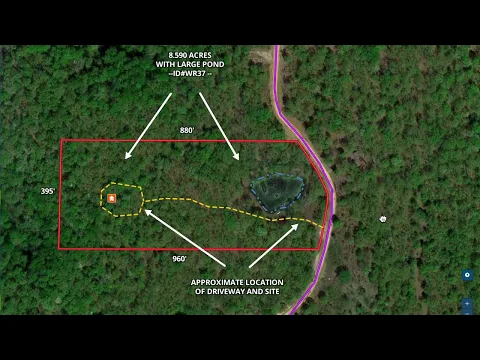
At 8.590 acres, this special tract is easily one of the largest at Whitetail Ridge. In fact, as we were looking over the maps while writing this listing we noticed that there is only one tract that is larger (at about 1/10th of an acre larger) BUT the “larger” tract has less than HALF of the “level area” that this rare tract has!
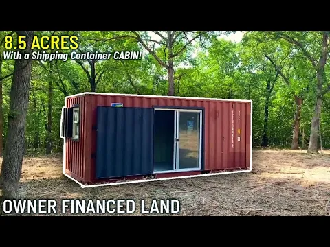
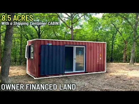
Combine all of that with a huge pond and loads of mature timber and you have got one of the most special properties we have ever offered. Because of those reasons, this particular tract was selected for the placement of a “Shipping Container Cabin” which you will find in the secluded cleared site, deep within this large property.
The “Shipping Container Cabin” is a 20′ shipping container which has had a sliding door installed, as well as two vinyl windows. When the door and windows were installed, the metal was carefully cut out and then fitted into separate steel frames and then fitted with heavy-duty hinges so that the Container could be securely locked when not in use (without those hideous metal “prison bars” over the doors and windows that you see on some containers).
The container is unfinished on the inside, giving you almost endless opportunities to set it up as a weekend cabin or possibly a tiny-home. Farther down in this listing we will have additional information about the “Shipping Container Cabin”.
Amazing location in the Ozarks. This acreage is located in a small Rural Development called “Whitetail Ridge” which is located within about 3 miles of the popular “Bennett Spring State Park” and even closer to the famous Niangua River. Also only about 10-15 miles from Lebanon, MO and less than an hour from Springfield, MO.
“Whitetail Ridge” is one of our “Homesteader Friendly Rural Developments”. This simply means that the standard Property Covenant requiring a minimum 600 square foot concrete foundation for a residence does NOT apply to the tracts at “Whitetail Ridge”. If you have been waiting for a property for your “tiny home” or for your “shipping container home” then you may have finally found what you are looking for!
PLEASE NOTE: This special tract was set up as a place to hunt for several of our workers and their friends. It has never before been offered for sale. The videos and photos within this listing are a mixture of very recent photos/videos as well as some photos/videos that were taken 1-2 years ago (just after the driveway and site were cleared and the “Shipping Container Cabin” was placed on the property. All of the photos/videos appear to show the property accurately, but keep in mind the photos/videos that were taken right after the driveway and site were cleared will not show any of the grass/greenery that has now grown up to provide ground cover to the driveway and site.
We apologize in advance for any confusion and please do feel free to reach out to us if you have any questions!
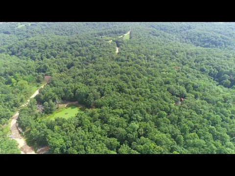
In the aerial photo below we are looking westerly over the property which borders the gravel easement road along its entire east side. The white truck is parked at the start of the private driveway which leads deep into the property. The driveway goes past the large pond and continues into the mature timber until you arrive at the clearing which is deep within the property and is where you will find the “Shipping Container Cabin”.

The photo below is a recent photo in which we are also looking north with the land on the left side of the road. In this photo you can see that the road has now been widened and improved.

The photo above shows part of the large pond on the property. This is a recent “winter” photo of the property. The large pond measure about 100′ X 150′ in size. Most “normal” ponds that we see are generally about 30′ X 30′ in size – that makes this large pond over 10 times larger than a standard pond, here in the Ozarks.
The next photo (below) gives us a look at part of the cleared site which is tucked deep into the property. In this photo you can see the “Shipping Container Cabin” which is located on the cleared site. This photo was taken directly after the cleared site and long driveway were created. In the photo it almost looks as though the cleared site is just “dirt” but in the photo we are actually seeing the millions of pieces of “ground-up mulch” that remained after a skid loader with a commercial mulcher was used to clear the site and the driveway. This photo was taken about two years ago and in that time the grass has grown in very nicely on the driveway and the site which provide a more “pleasing” appearance.

About the “Shipping Container Cabin” which is located on the property:
The 20′ Converted Shipping Container is VERY cool! Check out the details below:
- Durable used 20′ shipping container
- Insulated vinyl patio door installed in welded steel frame
- Insulated vinyl windows installed in welded steel frames
- Custom lockable security panels for patio door and windows
- Lockable end doors and lockable security panels for patio door and windows
- Security panels for sliding door and windows are hinged for ease-of-opening, but are also easily removable (if you desire) for total convenience
The Container is manufactured by The Survival Solution which is known for producing a VERY high-quality container that is specifically designed with your utmost security in mind! The security panels over the door and window can be locked while you are away from the Container, and they can either be opened or completely removed while you are using the Container.
The photo below gives us a look at part of the outside of the “Shipping Container Cabin”. This photo was taken about two years ago, directly after the site and driveway were created. On the ground you can see some of the mulched trees and brush. The entry door into the Container is a sliding patio door and there is also a window in the side wall and in the back wall. The other “end” of the Container has the large double doors that are standard on shipping containers.

In the photo below we are viewing the front of the Container with the Security Door closed over the sliding entry door. The security door is lockable and uses two heavy-duty welded hasps to accept up to two locks. Each window uses a single heavy-duty welded hasp to accept virtually any lock.

The photo below gives us a look at the rear of the Container. You can see the rear window (which has the Security Panel closed) and you can also see the end-wall window (which has the Security Panel open). When the Security Panels are open, they can be lifted off of the hinges to be completely removed from the Container (or they can simply be left on the hinges).

The “Shipping Container Cabin” is an exciting opportunity for someone to get a “head start” on a weekend retreat or maybe a tiny home. Within the last 2-3 years the price of Containers has gone up substantially and the price of any customization to containers has almost doubled! It is unlikely that we will have another opportunity to offer a Container with a property, so this is a rare chance to grab a Converted Container on a true top-shelf property.
The next photo (below) is a recent “winter” photo that was taken at the property. We are facing southerly on the easement road (Mauka Drive) which borders the property. The property is on the right side of the road in the photo.

And the next recent photo below gives us an updated look (although it is a “less than beautiful” winter photo). This photo was taken while standing on the private driveway which leads back to the cleared site and the Container:

ABOUT WHITETAIL RIDGE
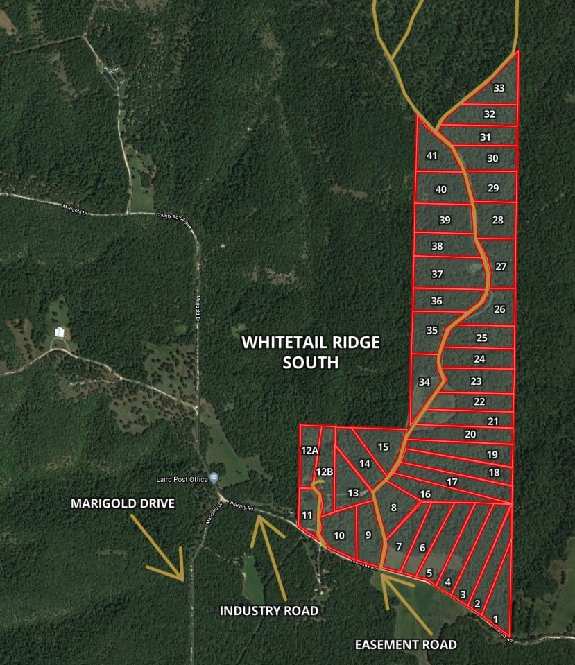
Whitetail Ridge South is an area of about 40 tracts located at the south side of Whitetail Ridge (as shown on the map below). Because these tracts are located at the south side of this rural development, they tend to have better access to the County Road, while still maintaining a very private setting. This listing is for Tract 37 which is 8.590 acres in size and can be seen on the map below.
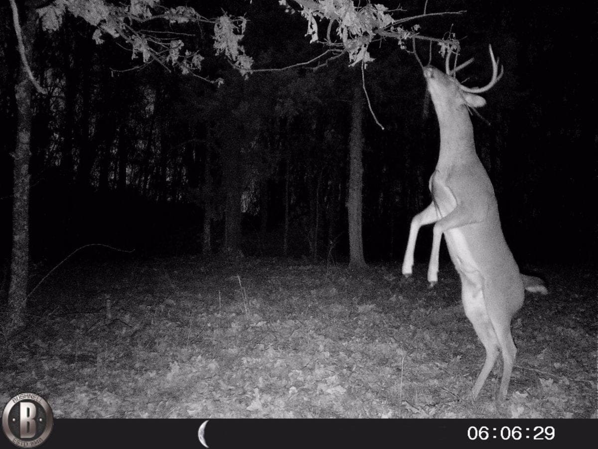
The hunting and wildlife watching opportunities in this area are EXCELLENT with a large population of white-tailed deer as well as wild turkey. Because this property has a huge pond, the deer are likely to spend more time on this tract than other tracts in the area. This property could also be suitable for off-grid building, homesteading, camping and recreation.
TERMS OF SALE
The full sales price for this 8.590 acre tract with the large pond, long driveway, cleared site, mature timber, huge level areas for additional enjoyment AND also including the “Shipping Container Cabin” is $99,500 and we offer INSTANT owner financing with just a $2,500 down payment.
With your $2,500 down payment you will automatically get our reduced annual interest rate of 6 3/4% and the monthly payment will be $893.37.
With a $5,000 down payment the annual interest rate drops to 5 3/4% and the payment drops to $819.74 a month.
These payments are all based on about a 15 year payment schedule. Property taxes & road maintenance fees total only $35 a month and this is already included in the monthly payment amount. There are NO prepayment penalties and NO hidden fees.
PLEASE NOTE that you have a TWELVE MONTHS to ADD to your down payment in order to reduce your interest rate and payment amount! We want to give ALL of our buyers the opportunity to achieve the lowest interest rate and payment amount possible!
ALSO, if you pay off your property (your loan to us) at any time within the next 5 years you will get a DISCOUNT in the amount of 10% of the purchase price of the property! On this property that would save you $9,950 for an early payoff!
The Tracts at Whitetail Ridge are sold through our partner company which is Regions Land Company. The sales process is the same as you see on the InstantAcres website, but the paperwork will shows Regions Land Company as the “seller”.
The Converted Shipping Container is supplied to us by The Survival Solution and we will be able to provide you with a Bill of Sale for the Container only after the entire property has been paid for in full. Under no circumstances may the Container be removed from the property or be structurally modified until after the entire property has been paid for in full.
In the winter photo below we are parked at about the start of the private driveway that leads into the property. In the distance you can see part of the large pond on the property. The driveway goes past the pond and then continues to the west as it winds through the mature hardwoods trees on the way to the Container and the cleared site. The property appears to have numerous mature oak trees (as well as other species) and thousands of younger trees.


The aerial map above shows how this tract is situated. It borders the easement road (Mauka Drive) along its entire east side for about 395 feet. On the map, we have added the approximate location of the private driveway and the cleared site (as well as the Container). The large pond is outlined in blue toward the east side of the property.

The topo map above gives you an idea of the “lay of the land”. This rare tract is basically level starting at the easement road on the east side and and stays basically level until you get back to the cleared site toward the west side of the property. Beyond the cleared site it appears to begin to slope down which gives you the potential for some beautiful views from the property.
It is very unusual for a property in the Ozarks to have this much level, usable area. We have sold properties over 100 acres in size that did NOT have as much level, usable area as this property does.

The photo above was taken while over the western side of the property, while looking to the east. Toward the bottom of the photo (near center) you can see the cleared site with the Container. If you look way past the cleared site you can see the large pond (hard to see because the lily pads are about the same color as the trees) and beyond the pond you will find the easement road (which does not appear to be visible in the photo.
VIDEOS!
Below, we have several videos of the property, including videos that were taken a couple of years ago (right after the site was cleared and the Container was placed on the property.
To see a drone video of the property that was taken right after the driveway and site were cleared (and the Container was placed on the property), please click on the video below.
Video Drone WR37 Narrated (Summer)
Next, we have a very long “Intro Video” where we use the MapRight Interactive Map to explore the property and the area. This is the longest “Intro Video” that we have ever done so make sure to grab yourself a snack before sitting down to watch this one!
Video Intro WR37 Narrated and Upgraded
Next, we have a “Ground Video” that was taken right after the driveway and site were cleared and the Container had been placed on the property:
Owner Financed 8 Acres in Ozarks with huge pond & shipping container cabin! InstantAcres.Com ID#WR37
As our last video, we have a “ground video” which was taken recently. Although it is a “winter” video it does goes us a nice look at some of the east side of the property as well as part of the driveway and cleared site:
Owner Financed ($1,500 Down) 8+ acres w/ Container Cabin and HUGE Pond! InstantAcres.com ID#WR37
This property is located in one of our favorite areas of the Ozarks. “Whitetail Ridge” is located in westernmost Laclede County, Missouri. People come from all over the state (and the country) to visit this area which includes Bennett Spring State Park and the Niangua River. This area is WELL KNOWN for a large and active deer and turkey population and this particular section of the Niangua River is one of the only places in Missouri where you can fish for rainbow and brown trout. This area is also within a short driving distance to Springfield (which is the largest city in southern Missouri).

The map above shows the property’s location, relative to the nearby roads and the Niangua River. The Niangua River, Bennett Spring State Park and the Barclay Conservation Area (which has awesome river access) are just a short distance from the property.
Within just a few miles of your private acreage at Whitetail Ridge you will find close to 10,000 acres of public land, most of which is open for hunting, fishing and exploring. You can set up your camp/cabin on your private tract and also have use of thousands of acres and miles of top-quality river frontage within just a few miles of your property!

The map above actually shows the location of Tract 39 at Whitetail Ridge but this property is just a few hundred feet south of that tract and we thought this would be a useful map, so we used it!
On the map above, the “Lead Mine Conservation Area” is just off the upper left corner of the map and it is a huge tract of land which is open for hunting, swimming, fishing, horseback riding and more (there is even a public shooting range). The Niangua River runs through Bennett Spring State Park and goes northerly through the Barclay Conservation Area and the Lead Mine Conservation Area before flowing directly into the famous Lake of the Ozarks (about 15 miles north of Whitetail Ridge).
The interactive map (below) is a great way to explore the property and the area, right from your home. You can zoom in, zoom out and even select different “base layers” to show the roads and areas in or around the property. You can zoom in and out by clicking on the “+” or “-” buttons on the right side of the interactive map. Depending on your internet browser, you may have to zoom in to see the property clearly (if the labels are covering it up):
The map above was created with a program called “MapRight”. The property boundaries on MapRight are only approximate but it should be helpful for exploring the property. This property has been surveyed with the corners marked
To read a detailed description about how to use the free “MapRight” app to locate the property as well as the property’s approximate boundaries, please visit the “F.A.Q.” page on our website and watch the short video about MapRight.
As we mentioned earlier on this page, the hunting in this area is world class. There is an excellent population of whitetailed deer and more turkeys than we have seen on practically any other property. Our guys set up a couple of game cams at Whitetail Ridge and they got hundreds of photo of large deer and turkey. Because this property has a large pond, it is very likely to attract more deer and turkey than any nearby properties.
You can definitely hunt on your property and you are also just a short drive to THOUSANDS of acres of public land for additional hunting, fishing, trail riding and recreation.
DIRECTIONS: To get to Whitetail Ridge from Lebanon, Missouri just go west on Highway 64 for about 12 miles to Bennett Springs State Park. Just BEFORE you cross the bridge over the Niangua River you go right (north) onto Marigold Drive (this is shown on many maps as Harvest Road but the sign at the road will likely say “Marigold”). Go a little over half a mile and you will come to a “Y” in the road. Go left at the “Y” (you are now REALLY on Marigold Drive). Continue north on Marigold Drive for about 2 1/2 miles and you will come to a “T” in the road. Go right (east) at the “T” and you are now on “Industry Road”. You now go about 1/2 a mile on Industry Road and you will see the road into Whitetail Ridge on the left side (north side) of the road. Go north onto the easement road and proceed to the property. The easement road is named “Mauka Drive” and there may be a street sign visible from the County Road. Once you are on “Mauka Drive” you will proceed to the north for a little less than a mile and the property will be on the left side (west side) of the road.
There are actually several different ways to get to this property so feel free to explore!
Please be sure to print out the maps/directions from this listing page when you visit the property. We will be happy to email the maps to you if you would like. Please contact us before making the trip to the property as there may be a locked cable/gate toward the start of the easement road. We will be happy to provide you with the combo for the lock when you contact us. As we mentioned earlier, the MapRight app is a very helpful tool when you visit the property. It is great to use when driving to the property and it is even better to use when you arrive.
Property near a major river or public land has been an excellent investment over the last several decades. As this area continues to grow, the demand for acreage continues to grow at a rapid rate. Lock in your property now, while you still can!
What can you do on your new property at Whitetail Ridge?
Although this tract is only about 10-15 miles from Lebanon, it is NOT subject to the zoning regulations that you will find in the immediate Lebanon area or the Springfield area! This property is within a Rural Development and does have basic property covenants BUT almost all of our buyers find that these covenants simply do NOT limit what they plan to do with their property!
On your property at Whitetail Ridge you can:
- Hunt
- Camp
- Build a cabin or a home
- Homestead
- Live “off-grid”
- Have a large garden
- Have animals (no kennels greater than 5 dogs)
On your property at Whitetail Ridge you can not:
- No commercial businesses (other than a home business)
- No cutting of the timber until the property has been paid for in full (we can often make written exceptions for clearing a building site or driveway)
- No junkyards of any kind
To see the full property covenants please click on the link below:
Whitetail Ridge Property Covenants
All of the tracts at Whitetail Ridge have setback distances from the easement road(s) and county road. These setback areas are also designated utility easements so that all owners may have the potential for electric service (at property owner’s expense). All buildings, homesites, parking areas, storage areas, etc. must be at least 100 feet from the center line of the easement road and county road (this area acts as a privacy setback as well as a utility easement).
Fences/gates may not be placed within 50 feet of the center line of the easement road(s) and county road as this area is a designated road easement area. Although there is a 30 foot setback for building/storage from the sides and rear of each tract you CAN fence directly up to the sides and rear of each tract (so long as all fencing is at least 50 feet off any shared roadway).

The cleared site at the end of the private driveway (where you will find the Container) is much larger than most sites that we have done. It looks as though it was designed for a large yard or to be large enough to pull in and get turned around, even when pulling a long trailer or camper.
This tract represents an excellent opportunity for building your own off-grid home or cabin as there are no building permits required in this area! You and your friends/family can build your own cabin without permits or inspections.

In the photo above we standing toward the end of the private driveway – we are about the enter the large cleared site and have a look at the Container.
TERMS OF SALE
The full sales price for this 8.590 acre tract with the large pond, long driveway, cleared site, mature timber, huge level areas for additional enjoyment AND also including the “Shipping Container Cabin” is $99,500 and we offer INSTANT owner financing with just a $2,500 down payment.
With your $2,500 down payment you will automatically get our reduced annual interest rate of 6 3/4% and the monthly payment will be $893.37.
With a $5,000 down payment the annual interest rate drops to 5 3/4% and the payment drops to $819.74 a month.
These payments are all based on about a 15 year payment schedule. Property taxes & road maintenance fees total only $35 a month and this is already included in the monthly payment amount. There are NO prepayment penalties and NO hidden fees.
PLEASE NOTE that you have a TWELVE MONTHS to ADD to your down payment in order to reduce your interest rate and payment amount! We want to give ALL of our buyers the opportunity to achieve the lowest interest rate and payment amount possible!
ALSO, if you pay off your property (your loan to us) at any time within the next 5 years you will get a DISCOUNT in the amount of 10% of the purchase price of the property! On this property that would save you $9,950 for an early payoff!
The Tracts at Whitetail Ridge are sold through our partner company which is Regions Land Company. The sales process is the same as you see on the InstantAcres website, but the paperwork will shows Regions Land Company as the “seller”.
The Converted Shipping Container is supplied to us by The Survival Solution and we will be able to provide you with a Bill of Sale for the Container only after the entire property has been paid for in full. Under no circumstances may the Container be removed from the property or be structurally modified until after the entire property has been paid for in full.
If this is the property for you then please choose your initial down payment amount in the box below and you may pay with your debit or credit card. Also please feel free to send us an email or give us a call and we can answer any questions or complete the transaction over the phone. Our number in the office is (417) 767-2223 and you can reach us by email at [email protected].


