SORRY, THIS PROPERTY HAS BEEN SOLD!
On Tract 31 at The Devil’s Backbone Project in Howell County, Missouri you will find a private driveway with cleared site for camping, hunting or building. This appears to be a heavily wooded property with an excellent mixture of red oak, white oak, hickory and many other types of trees. Access to the Mark Twain National Forest from within the Devil’s Backbone Project means that you have over 50,000 acres of additional land for hunting, camping, fishing, floating, exploring and recreation!
This heavily wooded 8.53 acre tract at “The Devil’s Backbone Project” is located within a private area called “Devil’s Backbone South”. This surveyed tract offers major privacy and seclusion as it is located toward the very end of the gravel easement road.
In addition to its privacy and beautiful mixture of timber, this tract is within an area well known for large deer and wild turkeys making it a PRIME property for hunting and recreation!
Please check out all of the videos in this listing to get a good look at this special property!

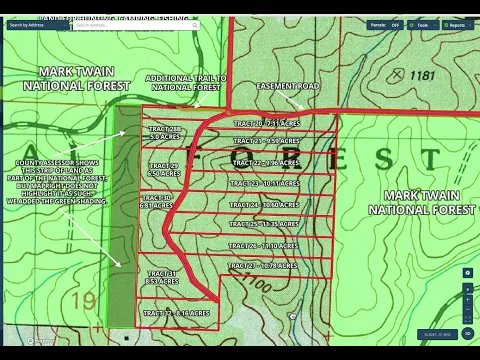
This property is Tract 31 on the map above. It is located toward the very end of the private easement road making it one of the most private tracts within the development. The west side of this large tract borders a section of land that we originally thought was part of the land within the Development, BUT upon further research the County Assessor’s map at first showed that the land directly west of this property is the National Forest and then when we checked a few weeks later the County Assessor showed the land as private property which is not part of the National Forest and is not part of the Devil’s Backbone Project. Our “MapRight” map did not highlight that section of land as National Forest so we had added the green shading to the strip of land directly west of the property to match what the County Assessor’s map was showing at that time. Although the strip of land was hunted and used by the previous owner of the entire development (before it was subdivided) as his private land, the County Assessor’s map now shows that strip of land as belonging to a different landowner in the area.
Even if the strip of land to the west of the property is not a part of the National Forest, you still have excellent access into the National Forest by taking the very short trail which is located just a few hundred yards to the north of the property (just to the north of Tract 28B on the map above).
This surveyed tract is located with an area called “Devil’s Backbone South” which is comprised of just a few tracts within the Devil’s Backbone Project. These special tracts offer major privacy and with the 50,000 acre Mark Twain National Forest only seconds away, you will never run out of top-quality land to explore and to hunt!
In addition to the usual videos that we put into basically all of our listings, we have added another video below. This short video shows an aerial photo of the driveway and cleared site that is tucked into the property (and was not visible on the aerial maps until recently):
Video Supplement Intro DB31 – 2024
This top quality acreage is brought to you by our Sales Partner “Outcast Land Inc”. Outcast Land is known for focusing on the highest quality hunting and recreation land in the United States. Every tract sold by Outcast Land is hand-picked for its hunting, recreation and investment appeal. Also, all Outcast Land tracts are buildable but they can not be used as a residence until after the owner financed loan has been paid in full (please see the “Homesteader Friendly” category if you are looking for a place on which to live in the near future). Because this tract is offered to you through our website at www.InstantAcres.com, the sales process is identical to the other tracts that we sell ($1,500-$5,000 Down Payment, Owner Financing, etc.). This tract can be purchased from this listing page if it is still available.
TERMS OF SALE
The full sales price for this special tract at “The Devil’s Backbone Project” is $59,500 and we are currently offering INSTANT owner financing with just a $1,500 down payment.
With your $1,500 down payment you will automatically get our reduced annual interest rate of 7 3/4% and the payment will be $580.94 a month.
PLEASE NOTE that you have a TWELVE MONTHS to ADD to your down payment in order to immediately reduce your interest rate and payment amount! We want to give ALL of our buyers the opportunity to achieve the lowest interest rate and payment amount possible!
With a $2,500 down payment the annual interest rate drops to 6 3/4% and the payment drops to $539.40 a month. With a $5,000 down payment the annual interest rate drops to 5 3/4% and the payment drops to $487.58 a month. These payments are all based on about a 15 year amortization schedule. Property taxes and maintenance fees total only $35 a month and this is already included in the monthly payment amount. There are NO prepayment penalties and NO hidden fees.
ALSO, if you pay off your property (your loan to us) at any time within the next 5 years you will get a DISCOUNT in the amount of 10% of the purchase price of the property! On this property that would save you $5,950 for an early payoff!
The Tracts at The Devil’s Backbone Project are sold through our partner company which is Outcast Land Inc. – The sales process is the same as you see on the InstantAcres website, but the paperwork will show Outcast Land Inc. as the “Seller”.
If this property is still available you may purchase it instantly through the “Buy Now” link on this page or you can call us in the office at (417) 767-2223 and we can answer any questions you may have or we can take your payment over the phone. Also, please feel free to email us at [email protected] and we can answer your questions via email.
Information about “The Devil’s Backbone Project”
“The Devil’s Backbone Project” was named after the popular “Devil’s Backbone Recreation Area” which is about 15 miles to the southwest and is one of the numerous areas within the Mark Twain National Forest that you can explore and enjoy.
“The Devil’s Backbone Project” is also sometimes called “Lomo Del Diablo” which we have been told is the Spanish translation for the phrase. When referring to land, a “devil’s backbone” is a long ridge which often has views on each side because of the way the land slopes.
We have a very limited number of these tracts at “The Devil’s Backbone Project”, which are some of the HIGHEST QUALITY hunting tracts in the nation. This area is consistently ranked one of the top hunting areas in Arkansas/Missouri (and in the nation). Many of these private tract offer DIRECT FRONTAGE on the Mark Twain National Forest. In total, the National Forest gives you over 100,000 acres of ADDITIONAL acreage for hunting, camping, fishing, trail riding and recreation (some of which can be accessed directly from the properties).
If you have not already seen the full “Information Page” for The Devil’s Backbone Project (which includes a ton of information and videos), please feel free to click on the link below which contains some great general information about the area:
Click Here For More Info On “The Devil’s Backbone Project” (if you have not already seen it)
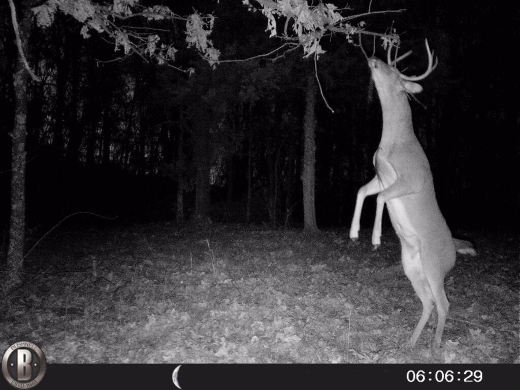
This area has a PROVEN track record for huge white-tail deer and enormous wild turkeys. In addition to being able to hunt and camp on your private acreage, you can also venture into the enormous Mark Twain National Forest for additional hunting and recreation (including camping, fishing, trail riding, hiking and more).
Information about this specific property (which is Tract 31 and is 8.53 acres in size)
This property is accessed via the gravel easement road which borders the entire east side of the property. The property appears to be basically all wooded other than the private driveway and cleared site which has been situated off of the easement road for privacy.
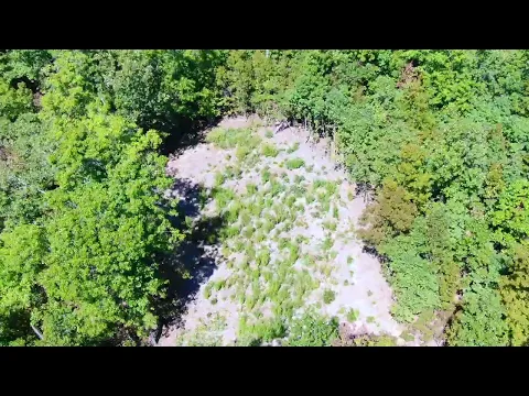
This very special tract does already have a driveway and cleared site tucked into the trees which can potentially save you a large amount of time, money and hassle, as you would have the option of pulling your truck/camper right onto your private acreage without having to create a driveway and site. Also, with a property of this size you will have numerous other locations that could potentially be suitable for additional sites for camping or building or for a food plot to attract the numerous deer and wild turkey in the area.

In the aerial photo above we are looking westerly over the property. At the bottom of the photo you can see the gravel easement road which borders the east side of the property. In the photo you can see the start of the private driveway which leads back through the trees to the cleared site. If you look very closely you can see the white truck which is parked on the easement road at the start of the private driveway which leads into the property.
On this property you can expect to find numerous species of trees including red oaks, white oaks, hickory trees and more!

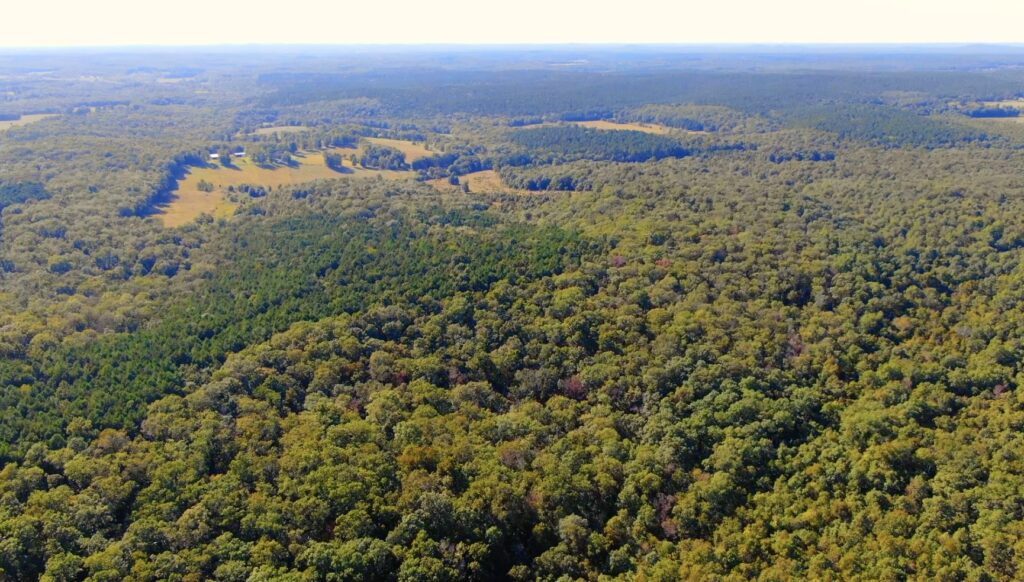
In the aerial photo above we are now probably a couple of hundred feet into the property and we are looking westerly. At the lower right side of the photo you can see part of the cleared site which is tucked into the trees within the property. The National Forest is off in the distance.

In the photo above we are looking northerly from somewhere over the property. Within this immediate area you will find thousands of acres of National Forest (some of which can be seen in the photo above).

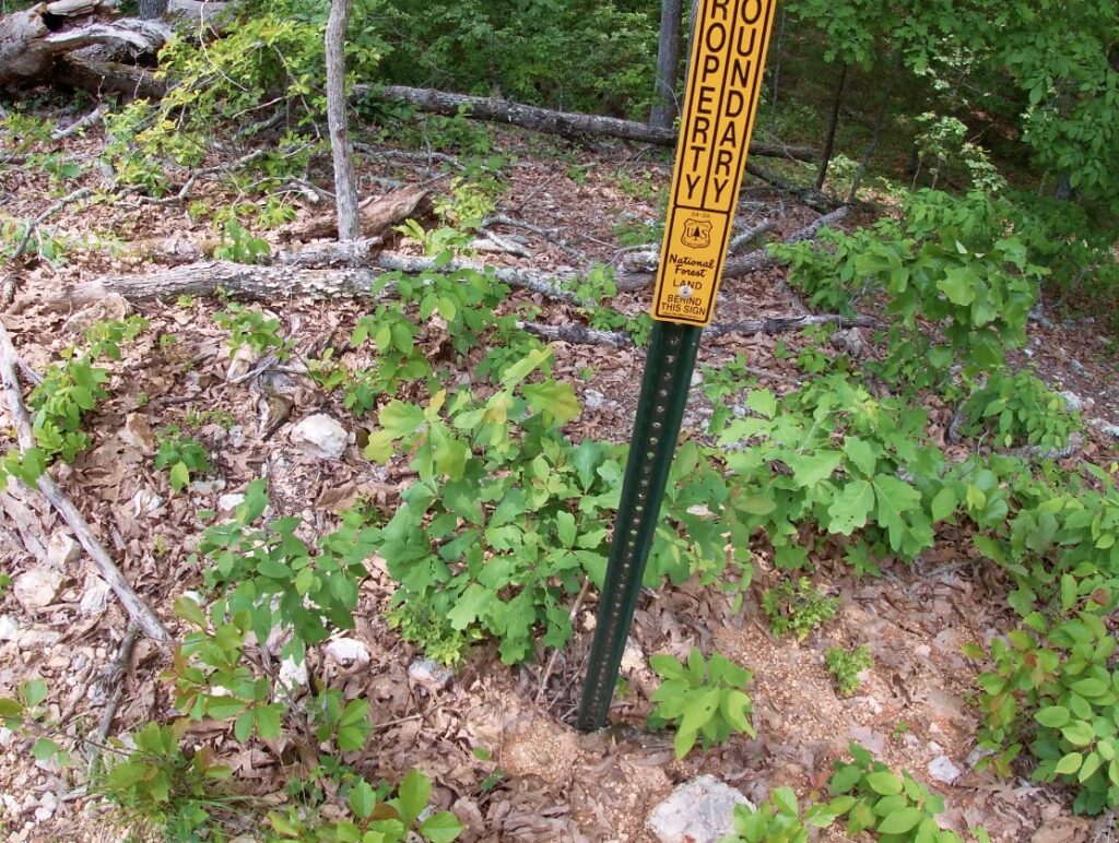
The photo above was taken from one of the roads within the development. We are looking directly into the National Forest which gives you a huge amount of additional land to use and enjoy. The National Forest is fairly well marked with the rectangular yellow/orange signs that you see in the photo above.

Tract 31 is 8.53 acres in size and it has been surveyed with the corners marked. Although a survey is not required on a property, it can be an excellent investment. It potentially saves you thousands of dollars by having a survey already completed on this large tract.

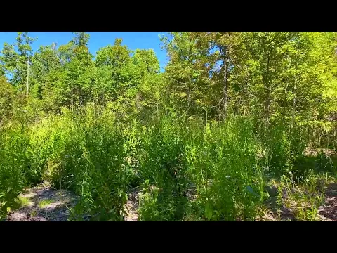
The cleared site appears to be large enough that you can pull in with a big camper and still get parked and turned around without having to remove timber. Although the weeds have started to grow in the photo above, a weed wacker would likely be an easy way to remove them. If you spread some grass seed then it won’t be long until the grass starts to really cover this private clearing (or that will tend to happen naturally if the clearing is mowed every 1-2 years).
This particular tract has frontage on the gravel easement road along its entire east side. We ALWAYS recommend a four wheel drive truck or suv for properties located on a gravel road/easement road. The four wheel drive may be useful if there has been bad weather and most trucks/suv’s have more clearance than a car which could be necessary if you encounter “rough spots” in the road.

The aerial photo above shows how this private acreage is situated. The easement road borders the entire east side of the property. The private driveway goes west off of the easement road and leads back to the circular cleared area. The white dashed line on the map above shows the approximate location of the driveway and cleared site on the property. If you use the “Interactive Map” farther down in the listing you should be able to switch to a google basemap ,which does now show the driveway and the cleared site on the property (and the location is similar to the outline above).
Please see the interactive map (farther down on this listing page) to explore the property as well as the area. There are setback distances from all shared roadways (the easement road). This property is surveyed with the corners marked. We will be happy to email you a copy of the survey map for your records when you purchase the property.

The topographic map above shows the “lay of the land”. The property is the highest at its east side, near the easement road. As you head westerly it appears to stay fairly level (especially on the north side). As you go west from the cleared site the topo map shows that the property begins to slope down into a small “valley” area. As you continue west from the small “valley” the property begins to slope back up.
Videos:
Below, you will see a few videos which will help you to “explore” the property. First, we have a drone video showing the property from the air:
Video Drone DB31 Narrated
The next video is a “ground video” where we check out a small part of the west side of the property.
Video Ground DB31 Summer Done
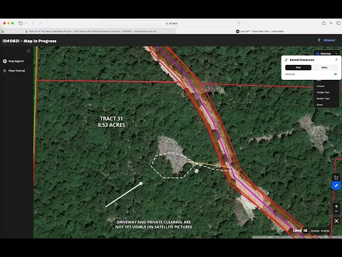
In the last video (below) we use the “MapRight” interactive mapping program to explore the tracts at Devil’s Backbone South. It is not as exciting as a drone video but it does have some good information:
Video Intro Devilu0027s Backbone South Updated
MapRight Interactive Map
The “MapRight” interactive map (below) is useful for exploring the property and the area. You may have to “zoom in” in order to see the property. You can also move the map around and even use different “base layers” to view the property:
Please refer to our interactive map above (MapRight Map) for additional property views and information. The MapRight boundaries are approximate BUT this property has already been surveyed with the corners marked.
About the free “MapRight” app that you can use to help check out this property:
To read a detailed description about how to use the free “MapRight” app to locate the property as well as the property’s approximate boundaries, please click on the link below:
Click Here To See A “MapRight” Tutorial
You will want to download the “MapRight” app to your phone or tablet before you visit the property, as it will make things go smoothly on your first trip (just follow the directions in the tutorial). Although many of the properties will have a sign with the “Tract Number”, having and using MapRight will make your trip quite a bit easier. It is also VERY useful for exploring the property and the area.
As you may already know, the deer hunting in this area is some of best in the nation. Turkey hunting is excellent as well. On this tract you can hunt, camp, ride your four wheeler, shoot your gun(s) and generally just relax and enjoy life. This tract is definitely buildable, subject to the basic property covenants which are the same for all Outcast Land tracts. If you wish to use this property as a full-time residence, your home/cabin must be at least 600 square feet on a concrete foundation and the owner-financed loan must be paid off. The land does not have to be “free and clear” in order to live on the property but the owner-financed loan to Outcast Land Inc. must be paid off (so if you “refinance” through your bank or another lending institution then the “owner financed” loan would be paid off).
You can build a hunting cabin right away, if you choose to do so. A hunting cabin would not have to be on a concrete foundation or be 600 square feet in size (those are requirements for a residence, not a hunting/vacation cabin).
The rest of the Property Covenants are very similar to the standard covenants that you may be familiar with on many of the InstantAcres.com tracts EXCEPT that on the Outcast Land tracts (including this tract) you have a full 90 days for camping in a 12 month period, which is twice as long as the standard 45 days a year. Also, your camping is never limited during deer season (rifle season) or spring and fall turkey season. Outcast Land never wants to limit your hunting opportunities!
If you have already seen the information page for The Devil’s Backbone Project than you have probably already seen the list of property covenants. If you have not, then please click on the link below to see them:
To see the Outcast Land Property Covenants please click here.
If you are looking for a property for “Homesteading” or living in a tiny home/shipping container/portable building then we can help you (but not with this tract) – just go back to the InstantAcres.com home page and click on the category for “Homesteader Friendly Tracts”. But, if you are a serious hunter or recreational user (who may want to live on the property some day) then you are already looking at the correct listing! You can definitely have a portable building or a camper/RV on this property for camping and hunting (just not as a residence). In fact, we know many people who have built a small hunting cabin in a weekend, with materials that fit in the back of a suburban or a pickup truck. Remember, you can definitely build a home/cabin on this tract at any time, it just can not be used as a residence until after the Owner Financed loan has been paid in full.
Please note that timber with a stump diameter larger than 8 inches may not be cut, sold or removed until the property has been paid for in full (we can often give written exceptions for creating a building site or a driveway/trail, contact us for details on this).
In the aerial photo above we are checking out a small part of the Mark Twain National Forest. Having this HUGE amount of public land at your doorstep gives you an endless opportunity for hunting, camping, fishing, hiking, trail riding and exploring!
Properties this close to the National Forest are rare and are in demand. Own your private acreage and have nearby access into a HUGE amount of additional land for hunting and recreation! You could spend a lifetime exploring the National Forest and still not see all of the trails, creeks, rivers, caves, campsites and other cool areas!
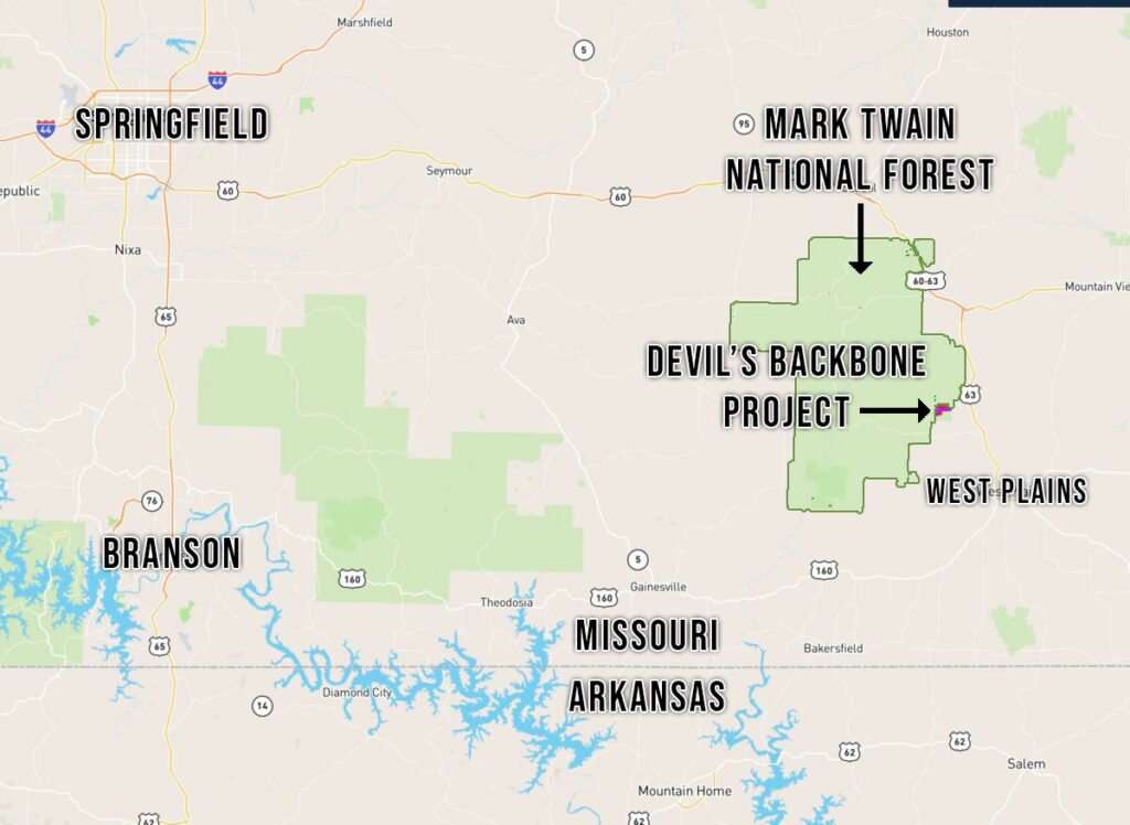
This property is located in an excellent location within the Ozarks. These tracts are located just a few miles from West Plains (which is the largest regional town) and only about 1 1/2 hours east of Springfield, Missouri (which is the largest city in southern Missouri). The Mark Twain National Forest (which directly borders many of the tracts) offers THOUSANDS of acres of additional land for hunting, camping, fishing, swimming, trail riding and recreation.
What can you do on your new property at “The Devil’s Backbone Project”?
These tracts are NOT subject to the zoning regulations that you will find in most areas of the country! This property is within a Rural Development and does have basic property covenants BUT almost all of the Outcast Land buyers find that these covenants simply do NOT limit what they plan to do with their property. In fact, most Outcast Land buyers that we speak to would simply NOT buy a property without basic covenants in place to protect their investment!
On your property at The Devil’s Backbone Project you can:
- Hunt (most buyers will buy a tract with deer and turkey hunting in mind)
- Camp
- Build a cabin or a home (subject to property covenants)
- Have a portable building or shipping container (for camping, hunting, recreation and storage)
- Use your camper or RV for camping, hunting and recreation
On your property at The Devil’s Backbone Project you can not:
- No commercial businesses
- Can not live on the property until the owner financed loan has been paid in full
- No cutting of the timber until the property has been paid for in full (we can often make written exceptions for clearing a building site or driveway/trail)
- No junkyards of any kind
All of the tracts at The Devil’s Backbone Project have setback distances from the easement road for privacy and to maintain the natural “feel” of the area. These setback areas are also designated as potential utility easements. Although power is not currently within the development, having the easements in place makes it a possibility (obtaining and extending power would be at buyers’ expense). All buildings, homesites, parking areas, storage areas, etc. must be at least 100 feet from the centerline of the easement road (this area acts as a privacy setback as well as a utility easement). Many of the tracts already have a private driveway and a clearing in place and the clearing is generally beyond the setback distance so it can be used for camping, parking, building, etc. (measure it if you are unsure).
Fences/gates may not be placed within 50 feet of the centerline of the easement road, as this area is a designated road easement area.
These tracts represent an excellent opportunity for building your own off-grid home or hunting cabin as there are no building permits required in this area! You and your friends/family can build your own cabin without permits or inspections.
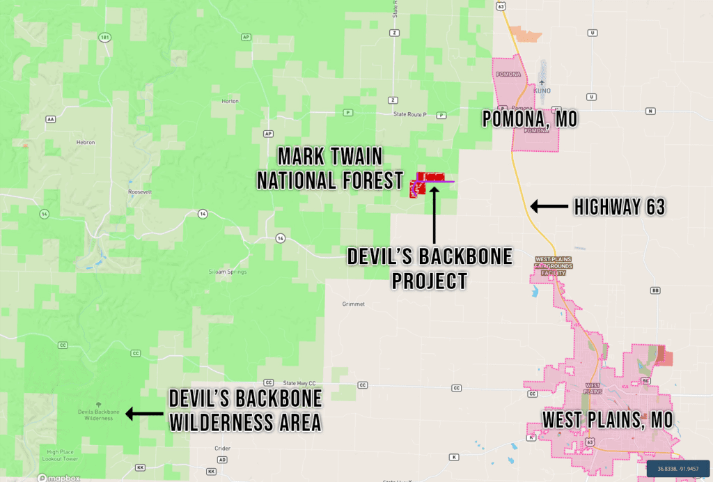
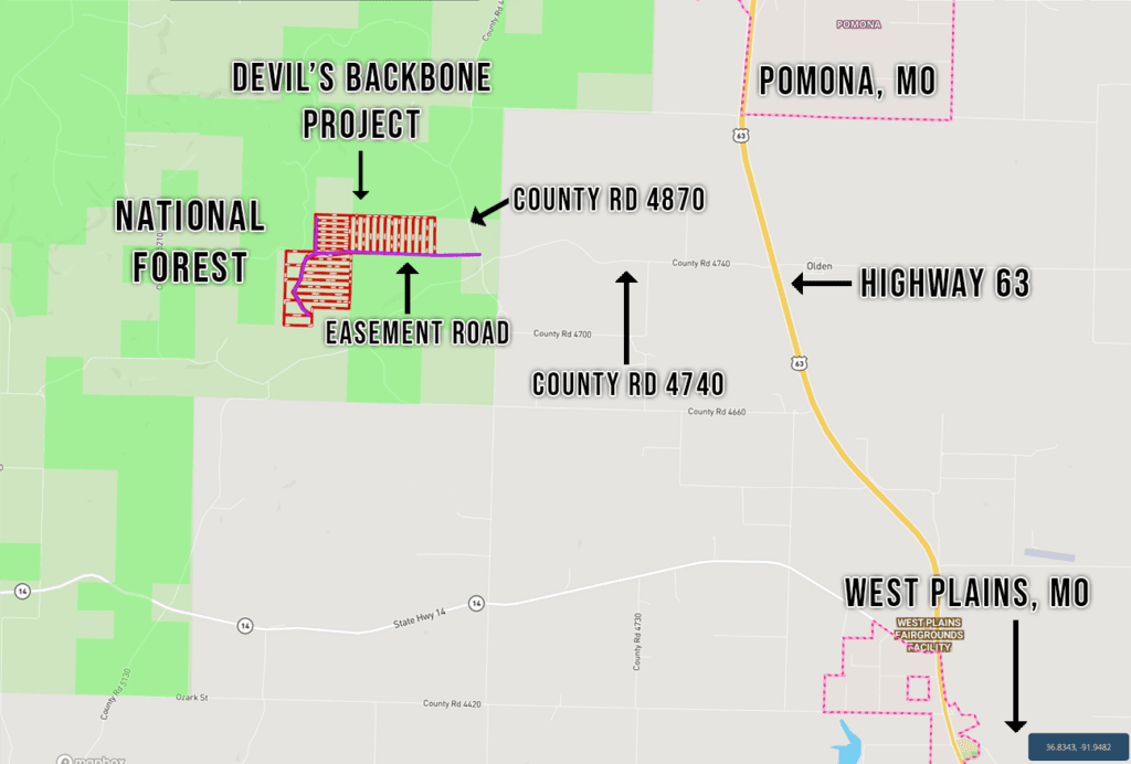
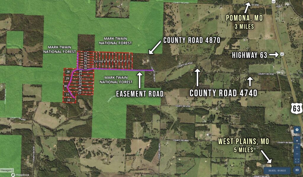
DIRECTIONS: To get to The Devil’s Backbone Project from West Plains, Missouri just go north on Highway 63 for about 5 miles and then go west onto County Road 4740. Go west on County Road 4740 for two miles and you will come to County Road 4870. Take a right (go north) onto County Road 4870 and proceed for about 400 feet. Look to your left and you will see the start of the easement road which will bring you back to the tracts. There is a gate near the start of the easement road (about 100 feet back from the County Road) so please contact us before visiting the tracts so that we can get you the combination for the gate.
Please be sure to print out the maps/directions from this listing page when you visit the property. Additionally, if you watch the video on our “F.A.Q.” page it will explain how you can download the free “MapRight” app which can be very useful for getting to the tracts, as well as exploring the tracts and the area.
The map below shows the route to the property from West Plains, Missouri:
The next map gives you a closer look at the last couple of miles of the drive to the property:
The map below is similar to the one above, except that it shows an aerial view of the area:
These tracts do not have a specific “street address” because there has never been a residence on them) – but if you would like an approximate address to put into your G.P.S you can use:
County Road 4870, Pomona, MO 65789
The address above will help get you to the area and you should be able to locate the tracts by using the maps/directions in the listing (as well as using the MapRight app). Although West Plains is the largest city in the area, these tracts will likely have a “Pomona, MO” street address as they are within the Pomona mailing area. After your property has been paid for in full (or you have paid off the owner financed loan) then you would be able to contact the local post office to apply for a street address for your property.
As land prices continue to rise, many smart folks are realizing that by owing a property the directly borders the National Forest they are able to use thousands of acres of land for hunting and recreation without having to purchase an enormous property. Many of the hunters that we speak to tell us that they are looking for at least a few hundred acres of land OR for a smaller tract that is close to the National Forest. By having a 3-5 acre tract, close to the National Forest, they are able to focus their resources on their own private acreage while still having access into thousands of acres of additional land for hunting, trail riding and recreation!
Good quality hunting land in the Ozarks has been a proven investment for many years and demand for property bordering the National Forest is growing by the day! As the demand for the top quality hunting tracts continues to grow, the values will continue to rise. This tract represents an excellent opportunity for hunting, camping, off-grid building, recreation and investment. If you live or work in the Ozarks then you already know that our land values have been steadily climbing for years. Lock in your property now, before our land prices catch up with the rest of the nation!
TERMS OF SALE
The full sales price for this special tract at “The Devil’s Backbone Project” is $59,500 and we are currently offering INSTANT owner financing with just a $1,500 down payment.
With your $1,500 down payment you will automatically get our reduced annual interest rate of 7 3/4% and the payment will be $580.94 a month.
PLEASE NOTE that you have a TWELVE MONTHS to ADD to your down payment in order to immediately reduce your interest rate and payment amount! We want to give ALL of our buyers the opportunity to achieve the lowest interest rate and payment amount possible!
With a $2,500 down payment the annual interest rate drops to 6 3/4% and the payment drops to $539.40 a month. With a $5,000 down payment the annual interest rate drops to 5 3/4% and the payment drops to $487.58 a month. These payments are all based on about a 15 year amortization schedule. Property taxes and maintenance fees total only $35 a month and this is already included in the monthly payment amount. There are NO prepayment penalties and NO hidden fees.
ALSO, if you pay off your property (your loan to us) at any time within the next 5 years you will get a DISCOUNT in the amount of 10% of the purchase price of the property! On this property that would save you $5,950 for an early payoff!
The Tracts at The Devil’s Backbone Project are sold through our partner company which is Outcast Land Inc. – The sales process is the same as you see on the InstantAcres website, but the paperwork will show Outcast Land Inc. as the “Seller”.
If this property is still available you may purchase it instantly through the “Buy Now” link on this page or you can call us in the office at (417) 767-2223 and we can answer any questions you may have or we can take your payment over the phone. Also, please feel free to email us at [email protected] and we can answer your questions via email.


