Read the “Terms Of Sale” a little further down in this listing page for more details and to see how you can get an even lower interest rate!
You could easily search an entire lifetime and not find a property this special and with so many unique features. In fact, this large wooded property has so many excellent features that we will list some of them below (so that you won’t have to read through the entire listing just to find out some of the details of this gorgeous 40 acre property!).
Partial List of Features on this Private 40 acre tract of land:
- DIRECT frontage on the 400 acre Cedar Gap Conservation Area. This gives you the ability to go straight from your property into the huge Conservation Area, which can generally be used for hunting and recreation. It’s like having a 400 acre backyard (in addition to your private 40 acre “front” yard).
- Over 4,000 feet of frontage on the famous Bryant Creek! The Headwaters of Bryant Creek begin in the Conservation Area, and then the Creek heads southeasterly on its journey to Norfork Lake. Bryant Creek runs along basically the entire southwest boundary of this 40 acre property.
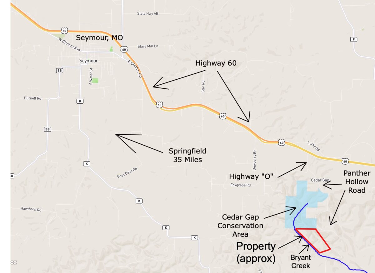
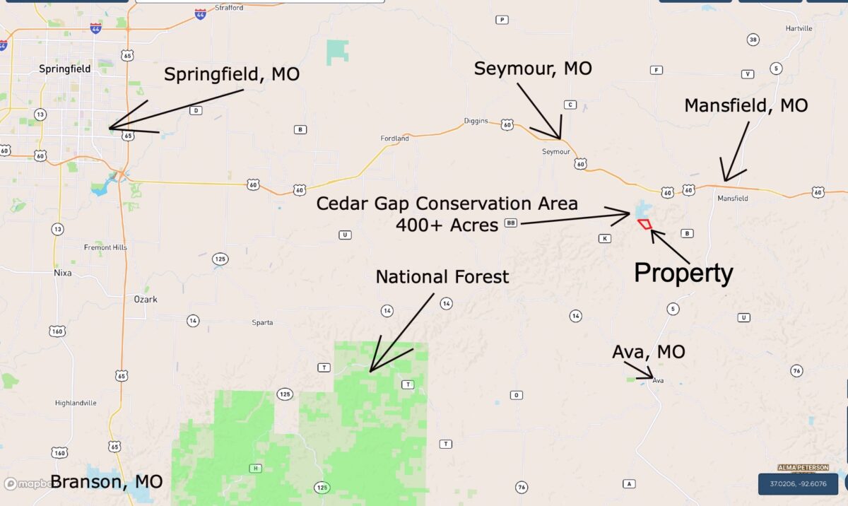
- Located in the private and rural southwest corner of Wright County, Missouri which also puts the property only about an hour east of Springfield, Missouri. Springfield is by far the largest and most popular city in southern Missouri.
- While exploring a small part of the property we discovered several very old (Civil War?) partial foundations/buildings that could easily date from the 1800’s or early 1900’s. These ancient homesteads are certain to provide endless hours of exploring and “treasure hunting”.
- Thousands of tall trees including red oak, white oak, sycamore, cedar, hickory and even numerous valuable black walnut trees.
Within this Listing Page you will find numerous maps, videos and photos showing the property. All of these things should be helpful in becoming familiarized with the property and the area.
This 40 acre property happens to be very close to a development that we did a couple of years ago called “The Panther Hollow Project”. This 40 acres is not part of that development, but if you have visited “The Panther Hollow Project” then you have driven right past this special property (which is located across the County Road from the northwest side of “The Panther Hollow Project”.

The map above shows the location of this 40 acres relative to “The Panther Hollow Project” (this 40 acres is just to the north of “The Panther Hollow Project”). As you look at the map above, you may notice that this 40 acre property has almost as much Bryant Creek frontage as all of the Panther Hollow tracts put together – wow!

In the photo above we are checking out some of the little fish that we found in Bryant Creek at the property. This photo was taken at about the center of the creek frontage at the property (photo is “grainy” since we zoomed in to see the fish).

In the photo above we are checking out Bryant Creek in one area where it directly borders the property. Bryant Creek is known as a very diverse creek. You will find that parts of the creek have a gravel bottom, parts have a flat rock bottom and some parts of Bryant Creek (like the part shown above) have multiple layers of flat rock which produce dozens of miniature waterfalls in the creek!
Because the actual Headwaters of Bryant Creek are only about a mile north of the 40 acres (in the Cedar Gap Conservation Area) this section of Bryant Creek does not necessarily flow all year long. There are times throughout the year when the creek will be flowing and there will be times when it is not.
In fact, it would be a normal occurrence to visit the property and find that the creek is flowing in some areas and is not flowing in other areas. This is often the case with creeks in the Ozarks. It is important to note, though, that when we visited the property the creek was flowing in most areas AND we found many schools of minnows and small fish within the creek. Generally, if you find minnows/fish in the creek then it is a strong sign that there is water in at least part of the creek throughout the year (otherwise you would not find any minnows/fish in the creek).

In the aerial photo above we are parked under some of the large mature trees on the property.

In the aerial photo above the truck is parked on a trail on the 40 acres. To the left you can see Bryant Creek, which flows southerly all the way down into Norfork Lake in Northern Arkansas.

In the photo above we are looking at one of the very old structures that we found on the property. The concrete structure was built right into the hillside. You can still see the rock steps which led to what was probably once the second story of the structure.

In the photo above we are looking at the lower part of the same stairs that were shown in the previous photo. It appears that a mature sycamore tree has spent the last several decades growing around the bottom stair!

In the photo above we are looking at an area of Bryant Creek that has a huge flat-rock bottom. The water is low in these photos, but it is still easy to see that Bryant Creek is known for its clear water.
We have priced this very special property MUCH LOWER than any other large waterfront acreage that we were able to find in the Ozarks. It is also priced MUCH LOWER than any acreage in the area that borders Public Land (this borders the Cedar Gap Conservation Area which is over 400 acres of Public Land).
With the MASSIVE amount of Bryant Creek Frontage, the frontage on the Conservation Area, the timber value (including valuable white oak and black walnut trees) and the value of the ancient homesteads, we think that someone is going to get an excellent deal on this wildly special property!
TERMS OF SALE
The original sales price for this 40 acre tract on Bryant Creek with direct Conservation Area frontage is $199,500 but we are currently offering a HUGE LIMITED TIME PRICE REDUCTION in the amount of $40,000 which brings this TEMPORARY sales price all the way down to $159,500.
With this temporary sales price of $159,500 we offer INSTANT owner financing with just your $1,500 down payment.
With your $1,500 down payment you will automatically receive our reduced annual interest rate of 7 3/4% and your payment will be $1,497.22 a month. This is about a 15 year payment schedule.
With a $2,500 down payment the annual interest rate drops to 6 3/4% and the payment drops to $1,399.31 a month. With a $5,000 down payment the annual interest rate drops to 5 3/4% and the payment drops to $1,292.99 a month. These payments are based on about a 15 year payment schedule. Property taxes total only $120 a year and this is already included in the monthly payment amount(s). There are NO prepayment penalties and NO hidden fees or charges.
PLEASE NOTE that you have a full TWELVE MONTHS to ADD to your down payment in order to reduce your annual interest rate and payment amount! We want to give ALL of our buyers the opportunity to achieve the lowest interest rate and payment amount possible!
ALSO, if you pay off your property (your loan to us) at any time within the next 5 years you will receive an ADDITIONAL DISCOUNT in the amount of 10% of the reduced purchase price of the property! On this property that would save you an ADDITIONAL $15,950 for an early payoff!
This special 40 acre property is sold through our partner company which is Outcast Land Inc. – The sales process is the same as you see on the InstantAcres website, but the paperwork will show Outcast Land Inc. as the “seller”.
If this property is still available you may purchase it instantly through the “Buy Now” link on this page or you can call us in the office at (417) 767-2223 and we can answer any questions you may have or we can take your payment over the phone. Also, feel free to email us at [email protected] any time.
Let’s check out a very cool MAP!
Interactive Map – “Land Id” Map – (formerly MapRight Interactive Map)
The “Land Id” interactive map below (formerly called “MapRight”) can be very useful for exploring the property and the area. You will probably have to “zoom in” in order to see the property on the map because the labels are likely to look VERY messy until you can zoom in on the property.
It will be helpful if you click on the link toward the top of the Interactive Map that says “Full Screen” which will open the map within a separate browser tab/window (although that works best on a desktop computer).
You can move the map around and even use different “base layers” to view the property and the surrounding area:
The map above has a large number of labels which will be kind of a pain until you get zoomed right in on the property (at which point the labels will be about where they should be). The property boundaries are only approximate on the interactive map but they will be helpful for exploring the property and the area.
About the free “Land Id” app that you can use to help check out this property:
To watch a short video that details how to use the free “Land Id” app to locate the property, as well as the property’s approximate boundaries, please click on the link below:
Click Here To See A “Land Id” (formerly “MapRight”) Tutorial
You will want to download the “Land Id” app to your phone or tablet before you visit the property, as it will make things go smoothly on your first trip (just follow the directions in the tutorial). If you have questions about Land Id please feel free to call us in the office at (417) 767-2223 and we can assist you. “Land Id” seems to be constantly updating their program so it can be a little confusing when you first get started. In fact, until very recently it was called “MapRight” so it is likely you will hear us use that name within the videos in this listing page, because that is the name we have been using for years!
PLEASE NOTE – Recently a few people have told us that they were required to get a “trial subscription” in order to use LandId. This may well be true because their policies do seem to change often. If you get the free trial membership please put a note in your phone/computer to cancel the membership after you have used it, so that you do not get billed for any actual subscription (unless you want the actual subscription, which is handy if you decide to use it more than a few times).
Now, let’s see some videos – Lots and lots of videos…..
Everyone likes videos! So we’ve included quite a few of them within this listing page. Click on any of the videos below to watch them within this listing page.
First, we have 3 separate videos which were taken while we were standing next to Bryant Creek at the property:
Video Ground HB40 HB80 in creek 1 Done
Video Ground HB40 HB80 in Bryant Creek 2 Done
Video Ground HB40 HB80 in Bryant Creek 3
Next, we have several drone videos which will show you the property as well as the area:
Video Drone HB40 Summer Narrated and Done
Video Drone HB40 Summer 2 Narrated and Done
Video Drone HB40 Early Spring Short Narrated and Done
Video Drone HB40 Early Spring Long Narrated and Done
In the next video we explore the area around one of the very old structures on the property:
Video Ground HB40 Exploring Narrated and Done
Check out all of the videos and pictures in this listing to get a good look at this rare property!


The video below is an “Intro Video” in which we use the Interactive Map to explore the property and the area. This is the longest of the videos but it does have a ton of good information:
https://youtu.be/K0dC49LoD_4
This top quality acreage is brought to you by our Sales Partner “Outcast Land Inc”. Outcast Land is known for focusing on the highest quality hunting and recreation land in the United States. Every tract sold by Outcast Land is hand-picked for its hunting, recreation and investment appeal. Also, all Outcast Land tracts are guaranteed buildable but they can not be used as a residence until after the loan has been paid in full (please see the “Homesteader Friendly” category if you are looking for a place on which to live in the near future). Because this tract is offered to you through our website at www.InstantAcres.com, the sales process is identical to the other tracts that we sell (Low Down Payment, Owner Financing, etc.). This tract can be purchased from this listing page if it is still available.
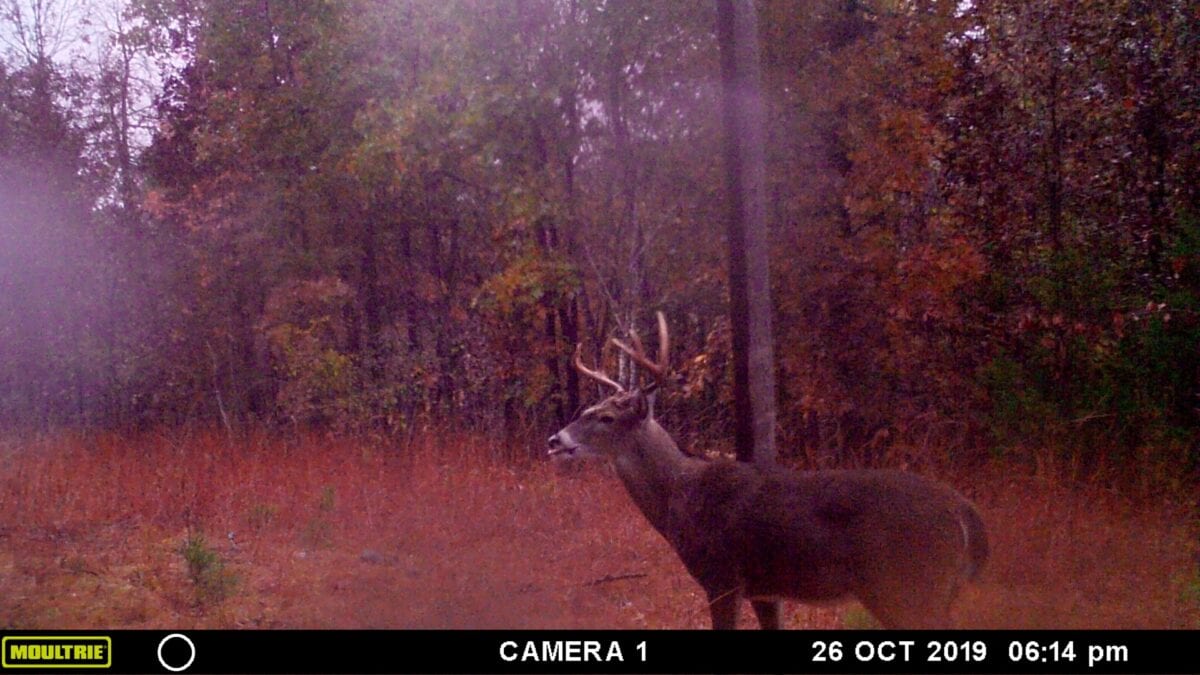
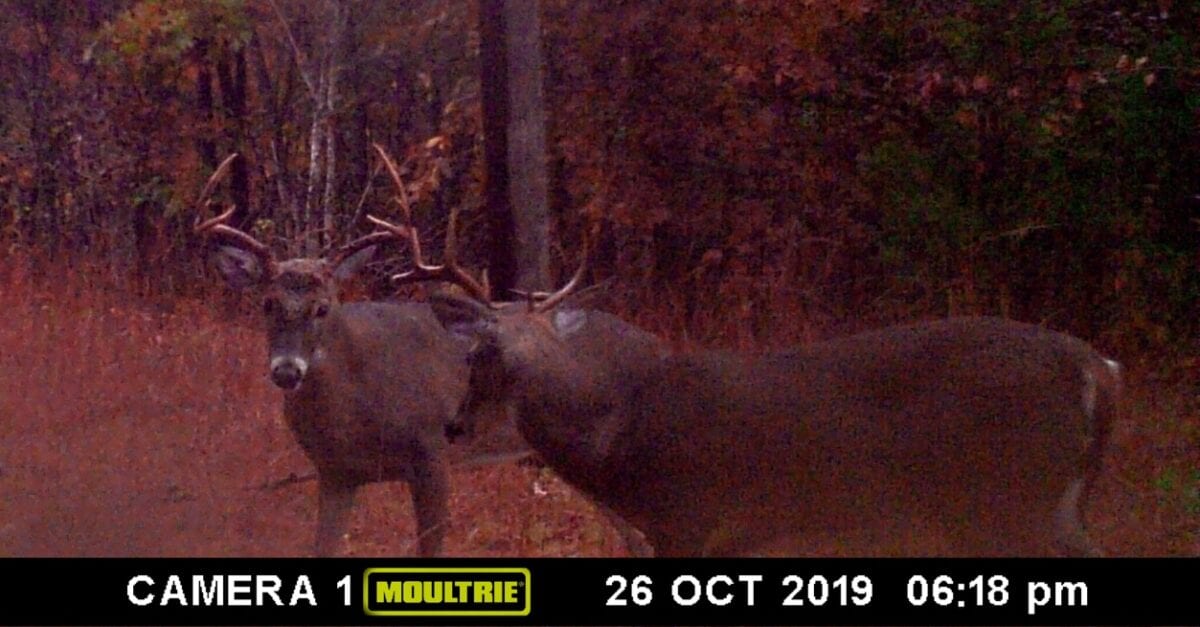
We have only this one 40 acre tract by the Headwaters of Bryant Creek, which is some of the HIGHEST QUALITY deer hunting acreage in the nation. Wright County is consistently ranked as one of the top deer hunting areas in Missouri (and in the nation). These tract is also within about 30 miles of the Mark Twain National Forest which gives you over 100,000 acres of ADDITIONAL acreage for hunting, camping, fishing, trail riding and recreation (huge tract of public land).


In the photo above, we are looking northerly at the spot where Bryant Creek crosses over Panther Holler Road. In this photo, the Deeded Easement into the property is on the left side of the County Road, a few feet past the creek. Although you can’t see the start of the Deeded Easement in this summertime photo, it begins on the left side (west side) of the County Road, about where you can see the patch of bright sunlight on the road. The photo above was taken about 3-4 years ago which was BEFORE the County installed the “Low-water Bridge” over Bryant Creek (see the next photo).
The next photo (below) was taken more recently than the previous photo and it does show the new “Low-water Bridge” over Bryant Creek. This photo was also taken in the same spot as the previous photo (we are looking north over Bryant Creek on Panther Holler Road). In this photo you actually can see the start of the Deeded Easement which is on the left (west side of road) about 30 feet north of the bridge. You will also notice there is a separate small road which goes the other direction (east) on the north side of the bridge. The road going to the east does not go to the 40 acres, you will need to take the road which goes west off of Panther Holler Road.


This property is basically all wooded, other than trails and building sites (and Bryant Creek). In the aerial photo above we are looking northwest over the property.
This large 40 acre tract is located about 10 miles south of Highway 60 which is the main east/west road in southern Missouri.

In the early springtime aerial photo above we are looking northwesterly at the property. Bryant Creek flows through the bottom of the valley that you see in the photo. Much of what you see on the right side of the center of the valley is the property, with the Cedar Gap Conservation Area on the right side of the valley toward the “top” of the photo. The trees at the bottom of the valley are the last to get their leaves in the Springtime, which is why they do not yet have leaves in the photo above. The valleys get just a little colder at night and take longer to warm up in the mornings, which is why those trees are always a few days behind the rest of the trees when growing their leaves. A large portion of the trees in the valley are big sycamore and black walnut trees, which do well growing near creeks (Bryant Creek flows through the length of the valley). The very dark green trees on the right side of the valley are cedar trees on the property. The bright white rectangle in the photo is the bridge over Bryant Creek on Panther Holler Road (you can see Bryant Creek flowing under the bridge in the photo).

The aerial photo above shows how this private acreage is situated. It is outlined with the red line on the aerial map and it kind of looks like a set of three stairs. Panther Hollow Road is the yellow and brown dashed line and the permanent deeded easement to the 40 acres is the purple line that comes off of Panther Hollow Road and goes west a few hundred feet into the property. Bryant Creek borders the entire southwest side of the property and is shown as the blue line on the map above. On the upper-left corner of the aerial map you can see a small portion of the Cedar Gap Conservation Area, where it directly borders the north side of the 40 acres for several hundred feet.

The topo map above may be helpful in seeing how the ground in the area “lays”. The 40 acres is the lowest at Bryant Creek and rises up as you move away from the creek. The property appears to be a mixture of level areas and steeper areas. There are several large level areas near the creek and several steep areas as you move away from the creek into the property. Some areas appear to rise up gradually with some appearing top rise up quickly.

The topo map above is a “close-up” of the ease side of the property, which is where we discovered the foundations/structures. The approximate location of the structures is actually shown on the topo map (as the black squares). This type of topo map was generally created in the 1950’s so we may be able to conclude that the buildings/houses were still in use in the 1950’s.

The photo above shows a partial foundation on one of the structures that we discovered. This may have been the “main house” as it appeared to us that it would have had a second story as well as some type of basement/cellar that had been dug into the hillside and lined with logs.
You will notice in the photos that some of the building materials appear fairly “modern”. For example, although the foundation appears to be from the early 1900’s (or late 1800’s), the silver colored piece of metal roofing in the background looks like something that was probably produced in the 1960’s or even later. This is something that we have noticed at several of the old building sites that we have discovered in the Ozarks. We have been told that the reason for the newer building materials is often that if a friend or a family member of the property owner (or the property owner themselves) needs an inexpensive place to stay, that it is not uncommon to give a very old structure an inexpensive “remodel” in order to turn it into somewhere that can be used as an inexpensive home (or for a hunting cabin). This is why it is not uncommon to see the newer building materials mixed into the very old structures.
The photo below is a good example of what we were just talking about. The concrete structure has been built into the hillside and the technique of the concrete work leads us to believe that the structure is from the very early 1900’s (or possibly earlier). But, just outside of the structure we can see what looks like some type of stove or wood furnace that appears to have been made in about the 1960’s and so was probably in use in the 1960’s or possibly the 1970’s.

So although it is possible that the structures on the property were in continuous use starting when they were built, it is just as possible that the structures were used for 1-2 generations when they were built and then were vacant for a number of years before being brought “back into service” by a family looking for an inexpensive place to live or maybe by a couple of hunting buddies who wanted a private place to hunt. We may never know!

The “infrared map” above is useful because it shows us that there are some natural “glade areas” on the property. An Ozark Glade is characterized by short native grass which is what gives it the “open” appearance on the infrared aerial photo.
As you may already know, the deer hunting in this area is some of best in the nation. Turkey hunting is excellent as well. On this tract you can hunt, camp, ride your four wheeler, shoot your gun(s) and generally just relax and enjoy life. This tract is definitely buildable, subject to the basic property covenants which are the same for all Outcast Land tracts. If you wish to use this property as a full-time residence, your home/cabin must be at least 600 square feet on a concrete foundation and the loan must be paid off. The land does not have to be “free and clear” in order to live on the property but the Owner Financed loan to Outcast Land Inc. must be paid off (so if you “refinance” through your bank or another lending institution then the “owner financed” loan would be paid off).
You can build a hunting cabin right away, if you choose to do so. A hunting cabin would not have to be on a concrete foundation or be 600 square feet in size (those are requirements for a residence, not a hunting/vacation cabin).
The rest of the Property Covenants are very similar to the standard covenants that you may be familiar with on many of the InstantAcres.com tracts EXCEPT that on the Outcast Land tracts (including this tract) you have a full 90 days for camping in a 12 month period, which is twice as long as the standard 45 days a year. Also, your camping is never limited during deer season (rifle season) or spring and fall turkey season. Outcast Land never wants to limit your hunting opportunities!
To see the Property Covenants please click on the link below.
To see the Outcast Land Property Covenants please click here.
If you are looking for a property for “Homesteading” or living in a tiny home/shipping container/portable building then we can help you (but not with this tract) – just go back to the InstantAcres.com home page and click on the category for “Homesteader Friendly Tracts”. But, if you are a serious hunter or recreational user (who may want to live on the property some day) then you are already looking at the correct listing! You can definitely have a portable building or a camper/RV on this property for camping and hunting (just not as a residence). In fact, we know many people who have built a small hunting cabin in a weekend, with materials that fit in the back of a suburban or a pickup truck. Remember, you can definitely build a home/cabin on this tract at any time, it just can not be used as a residence until after the Owner Financed loan has been paid in full.
Please note that timber with a stump diameter larger than 8 inches (measured at ground level) may not be cut, sold, disturbed or removed until the property has been paid for in full (we can often give written exceptions for creating a building site or a driveway/trail).

This property contains a large amount of beautiful, mature timber. In the photo below we are looking at a mixture of black walnut, sycamore and oak trees on the property (with a few cedar trees as well). In about the center of the photo you can just barely see Bryant Creek, which is mostly hidden by the tall trees.

In addition to the beautiful timber, you will find some very interesting rocks and rock formations on the property. Although it is hard to tell in the photo above, that impressive rock is about the size of a small car.

Because this section of Bryant Creek is near the actual Headwaters for Bryant Creek, and because it is a spring-fed creek, the water in the creek tends to be very clear and beautiful.

This property is only about 45 miles east of Springfield, Missouri. You can explore the Bass Pro Shops headquarters and still be back to your private acreage in time for a late breakfast.
DIRECTIONS TO THE 40 ACRES
DIRECTIONS: To get to the 40 acres at the Headwaters of Bryant Creek from Springfield, Missouri just go east on Highway 60 for about 40 miles and then go South onto State Highway O (the letter “O”). This is also the way that you get to the Parking Area at the Cedar Gap Conservation Area. Stay on Highway O for maybe a couple of miles and it will cross a set of train tracks and become “Panther Holler Road”.
As you cross the tracks, the paved road will turn into a gravel road and after you are over the tracks if you go straight for a few more feet you will be in the parking area for the Cedar Gap Conservation Area. So, you will need to go left directly after crossing the tracks. The road will go east for a short distance and then turn to the south (to the right). Now, stay on Panther Holler Road for 2-3 miles and you will start to slowly head down a long hill (not steep, but long). At the bottom of the long hill will be the concrete “low-water bridge” over Bryant Creek. The short Deeded Easement Road that takes you in to the 40 acres will be just BEFORE the low-water bridge (road/trail heads to the west on the north side of the little bridge). You will see the road heading west off of Panther Holler Road and this is the road that you will take a few hundred feet to get to the 40 acres.
Although the trail continues into the 40 acres, once you get onto the property it is no longer an easement for anyone else to use, so you could put a gate up on the Deeded Easement right at the east side of the 40 acres if you wanted to do so. The trail will lead you in toward the old structures and after that it becomes more of a trail for hiking or four wheelers.
Although Panther Holler Road is a County Road, you will still want to drive a truck or an suv as it will sometimes have rough spots (you will want a truck or suv anyway once you pull off of Panther Holler Road and in toward the 40 acres).
The aerial map below shows the route to the 40 acres from U.S. Highway 60:


Area Map showing the property as well as the route to the property.
Although there is a way to come in from the south, it is generally easier to come from the north (but feel free to explore both ways).
The Road Map below shows the route to the property from Highway 60 (same as previous maps, but with a slightly less “cluttered” map).

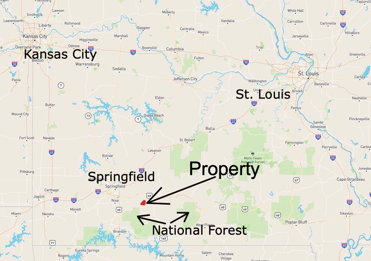
The map below shows the property relative to Springfield, Missouri as well as Kansas City, MO and St. Louis, MO.

We were only able to explore the property for a couple of hours, but we kept finding cool surprises! The photo below shows part of an old rock wall that we discovered next to one of the trails on the property.

Good quality land in Missouri has been a proven investment for many years. As the demand for the top quality tracts continues to grow, the values will continue to rise. This tract represents an excellent opportunity hunting, camping, building, recreation and investment. If you live or work in the Ozarks then you already know that our land values have been steadily climbing and that land within an hour of Springfield is leading the pack. Lock in your property now, while you still can!

Because this special property directly borders the Cedar Gap Conservation Area, you have direct access into over 400 acres of land for additional hunting, hiking and fun!

The photo above was taken while standing on the north end of the 40 acres and looking into the Cedar Gap Conservation Area. It’s like having a 400 acre backyard!
TERMS OF SALE
The original sales price for this 40 acre tract on Bryant Creek with direct Conservation Area frontage is $199,500 but we are currently offering a HUGE LIMITED TIME PRICE REDUCTION in the amount of $40,000 which brings this TEMPORARY sales price all the way down to $159,500.
With this temporary sales price of $159,500 we offer INSTANT owner financing with just your $1,500 down payment.
With your $1,500 down payment you will automatically receive our reduced annual interest rate of 7 3/4% and your payment will be $1,497.22 a month. This is about a 15 year payment schedule.
With a $2,500 down payment the annual interest rate drops to 6 3/4% and the payment drops to $1,399.31 a month. With a $5,000 down payment the annual interest rate drops to 5 3/4% and the payment drops to $1,292.99 a month. These payments are based on about a 15 year payment schedule. Property taxes total only $120 a year and this is already included in the monthly payment amount(s). There are NO prepayment penalties and NO hidden fees or charges.
PLEASE NOTE that you have a full TWELVE MONTHS to ADD to your down payment in order to reduce your annual interest rate and payment amount! We want to give ALL of our buyers the opportunity to achieve the lowest interest rate and payment amount possible!
ALSO, if you pay off your property (your loan to us) at any time within the next 5 years you will receive an ADDITIONAL DISCOUNT in the amount of 10% of the reduced purchase price of the property! On this property that would save you an ADDITIONAL $15,950 for an early payoff!
This special 40 acre property is sold through our partner company which is Outcast Land Inc. – The sales process is the same as you see on the InstantAcres website, but the paperwork will show Outcast Land Inc. as the “seller”.
If this property is still available you may purchase it instantly through the “Buy Now” link on this page or you can call us in the office at (417) 767-2223 and we can answer any questions you may have or we can take your payment over the phone. Also, feel free to email us at [email protected] any time.
If this property is still available you may purchase it instantly through the “Buy Now” link on this page or you can call us in the office at (417) 767-2223 and we can answer any questions you may have or we can take your payment over the phone. Also, feel free to email us at [email protected] any time. We look forward to speaking with you and to working with you!