![]()
We are very excited to be able to offer these heavily wooded, high quality tracts at the White River in Independence County, Arkansas. These tracts were designed to be very secluded, giving you maximum privacy while you are hunting, fishing and generally just enjoying life on your private acreage!
Below you will find a map showing “The Tracts at White River” which is located at the eastern shore of the famous White River in northern Arkansas. Directly below the map you will see a list/table showing the available tracts along with their prices. Click on the tract number of any available tract (within the list) to see the full information page for that tract.
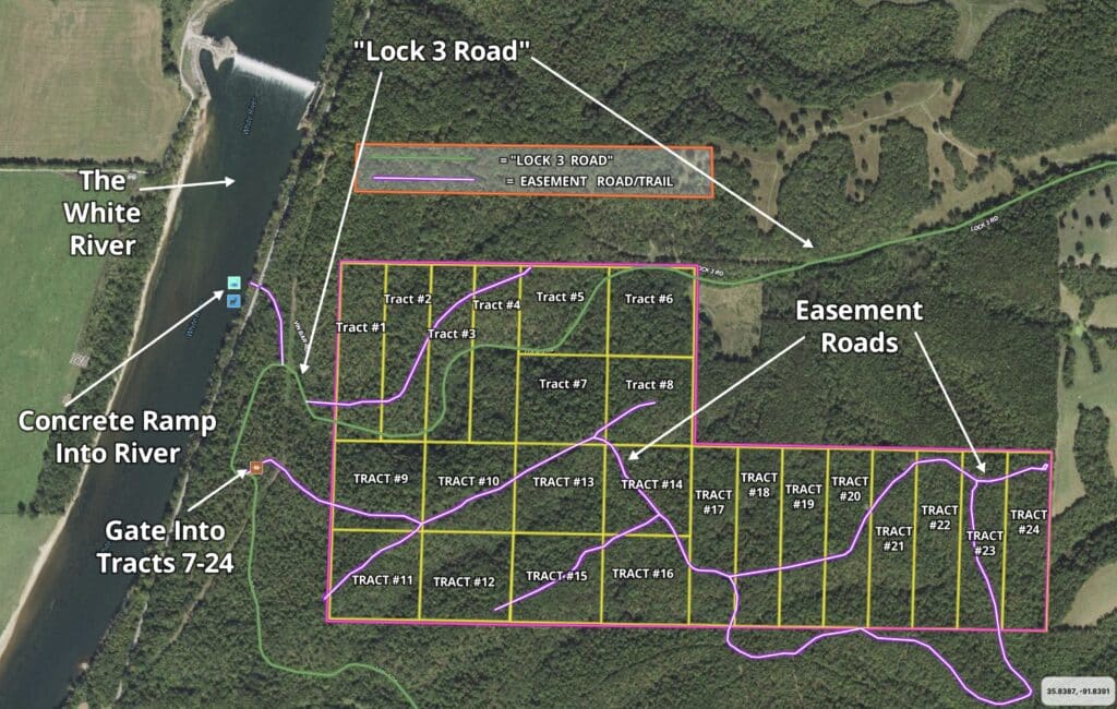
In the table above, just click on any of the tracts that are marked as “Available” to see the listing page for that specific tract (please click on the links within the table, as the map itself is not “clickable”).
We have tried to add a large amount of information about these properties and about the area to this listing page. Below, you will see an “Intro Video” which will give you some great information about these special tracts of land. Please note that many of the maps on this page show 24 tracts within the development, it is likely there will be a total of 36 tracts (which is what is shown in many of the videos within this page):
“Intro Video” below:

Intro Video White River Valley Tracts – ID#WW – Batesville Property
These excellent tracts are brought to you by our Sales Partner, “Outcast Land Inc.” – Outcast Land is committed to bringing you the HIGHEST QUALITY recreation land in the nation. All tracts are located in areas with a PROVEN track record for hunting, generally including white-tailed deer and wild turkey (and these special tracts also offer world class fishing in the famous White River). The “Hunting and Recreational Developments” brought to you by Outcast Land have basic Covenants in place to ENSURE that the tract you purchase can be used for hunting and recreation for generations to come. By they way, all tracts sold by Outcast Land are buildable for a cabin or home, subject to the basic property covenants (although most Outcast Land customers are more interested in deer “signs” then street signs). After making your down payment you can use your tract immediately for camping, hunting, recreation and much more. If you plan to actually live on your tract within The Tracts At White River then the owner financed loan (the loan to us) will have to be paid in full before doing so.
Not only are these tracts heavily wooded and situated in a great location for hunting, camping and recreation, they are also within just a few hundred feet of the very famous (and very popular) White River for some amazing fishing and canoeing!
The White River is a popular destination for fishing, canoeing and kayaking. Although you can fish for rainbow trout and brown trout in the White River, most of the people that we talked to in the area said they generally had the best luck catching bass and catfish (as well as sometimes walleye).
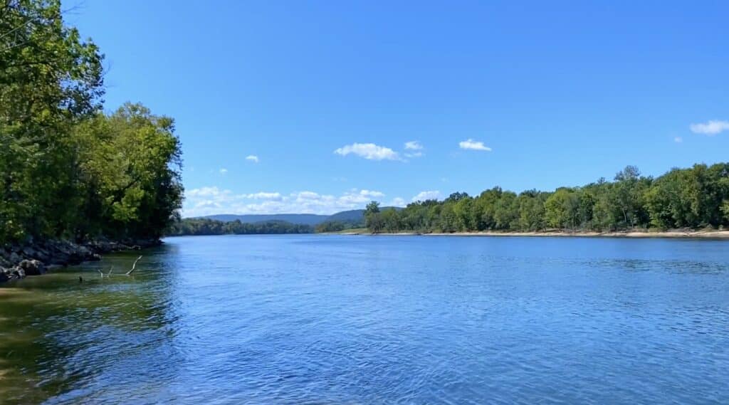
The picture above is a photo that we took of the White River from the river access point which is just to the west of these tracts (and shown on all of our maps). There is actually a concrete ramp (boat launch?) here which makes it fairly easy to access the river. In the photo above, we simply walked out toward the end of the concrete launch in order to snap a few photos. In the photo above we are looking down river (southerly), in the direction of Batesville.
Although we have had numerous people tell us that the concrete ramp at the river is a boat launch, we have not yet launched a boat from the ramp (although we hope to do so on a future trip to the property).
This acreage is in a fantastic area for deer and turkey hunting. On several of the tracts we have found deer stands built into the trees, which indicate that this has been successful hunting land for many years. Who knows what you will find when you fully explore your private acreage at “The Tracts at White River”.
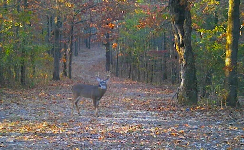
We put a couple of game cameras on the property a few months ago, and we got HUNDREDS of photos of deer and turkey.
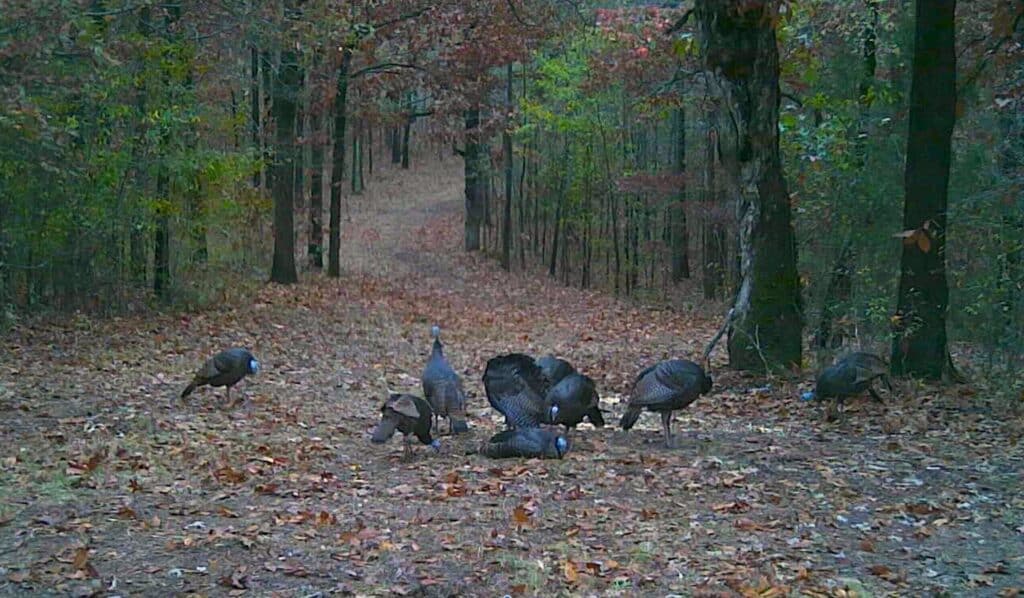
The photos above are from a game camera that we had placed near about the middle of the property. We don’t yet have any photos of fish from the White River (we keep forgetting to bring fishing poles) so if you plan to do a little fishing in the river when you visit the property we would LOVE to get a copy of any “fish photos” that you may get!
HUNTERS, CAMPERS AND RECREATIONAL LAND USERS have specific desires and requests when they are searching for their property. In general, these folks plan to camp and use their property more often than most people. They also generally do not plan to build a home and live on the property in the near future.
With these specific needs in mind, Outcast Land is proud to bring you this “Hunting and Recreational Development”. All of these tracts within this rural development are usable for hunting, camping, recreation and even building a home or cabin, but there are a couple of important distinctions that make these tracts special:
- All Outcast Land tracts are “buildable” but please keep in mind that they can not be used for a permanent residence until after the loan (to us) has been paid for in full. You can definitely build a cabin (or use a portable building) for camping/hunting but in order to live on the property the loan must be paid in full and the exterior of your residence must be complete and it must be over 600 square feet in size on a concrete foundation (details within Property Covenant page).
- Camping is allowed for 90 days a year, instead of the standard 45 days. This gives you twice as much camping/hunting time on your acreage.
- You can ALWAYS camp during the scheduled deer hunting season (rifle season) and turkey hunting seasons, even if that would put you over the 90 day period. Outcast Land does NOT wish to limit your hunting opportunities on your property.
Other property covenants (setback distances, etc) will be very similar to the standard Property Covenants that you see within the InstantAcres.com “property covenants” section. To see the Outcast Land Property Covenants for “The Tracts at White River” please click on the link below:
To see the Outcast Land Property Covenants for “The Tracts at White River” please click here.
Hunters and Recreational land buyers generally have no interest in living on their property in the near future (although often they do plan for a retirement or vacation home/cabin on the property). BUT, many Hunters, Campers and Recreational land buyers do tell us that it can be a hardship to have nearby neighbors living in portable buildings, camper trailers or homemade “tiny homes” while they attempt to enjoy their acreage for hunting/recreation with their friends and families.
We love “homesteaders” and you may also love “homesteaders” but these tracts from Outcast Land are not designed for the “homesteader”. These tracts are designed for the serious hunter/camper/recreational user who does not desire to be surrounded by homesteaders while hunting and using their property.
These tracts contain timber of all sizes and they do contain mature timber. Please note that timber with a stump diameter larger than 8 inches (when measured at ground level) may not be cut, sold or removed until the property has been paid for in full. We can, and often do give written exceptions to this rule for the purposes of creating a building site or a driveway/trail, but you must obtain written permission from us PRIOR to the removal/cutting/marking of any timber (unless you have already paid for your property in full, in which case you can do as you please with the timber on your tract).
Now, let’s take a closer look at “The Tracts at White River”!
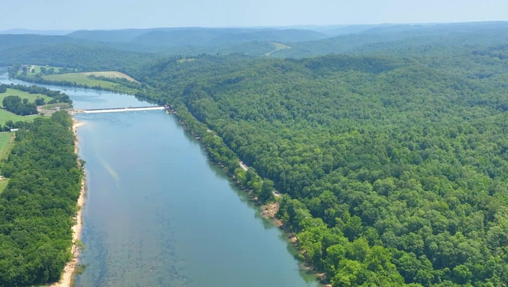
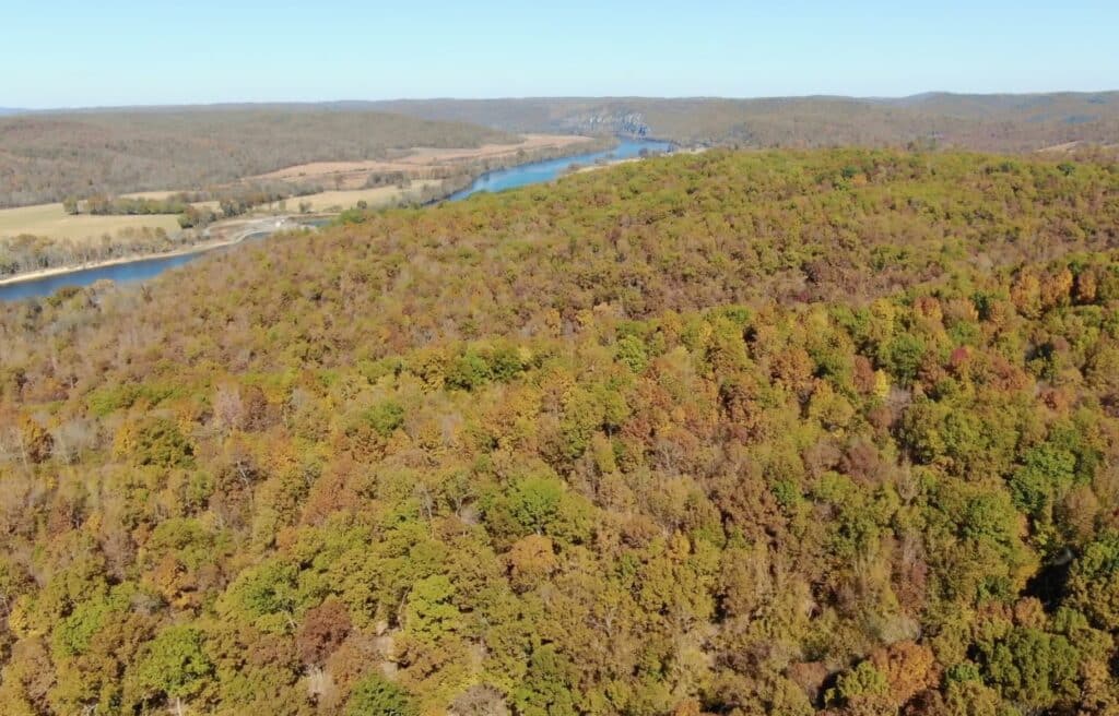
In the aerial photo above we are facing north over the White River, and the property is on the right side (east side) of the river. In the distance (on the river) you can see “Dam and Lock Number 3”. If you look a few feet to the right of the river in this photo you will see what appears to be a gravel road which runs parallel to the river – but this is actually an old set of train tracks. In the early 1900’s these tracks were used quite a bit in order to transport the minerals (mostly manganese and limestone) which were extracted from local mines. After about the 1950’s the demand for U.S. manganese dropped (as we could get it more cheaply from overseas) so the mines were closed. We have been told that the tracks are still used for just one or two special trains which transport a rare type of sand from the local area (a few miles away) to other destinations.
One of the many reasons that these properties are so special is that they in just about the only location in this area in which you have easy access to a concrete ramp into the White River. Because of the train tracks which run parallel to the river, there are VERY few spots on the east side of the White River in this area that you can use for accessing the river. This is because there happens to be an existing concrete train trestle which enables you to cross UNDER the train tracks. Immediately on the other side of the train trestle you will find the concrete ramp which extends out to the river.
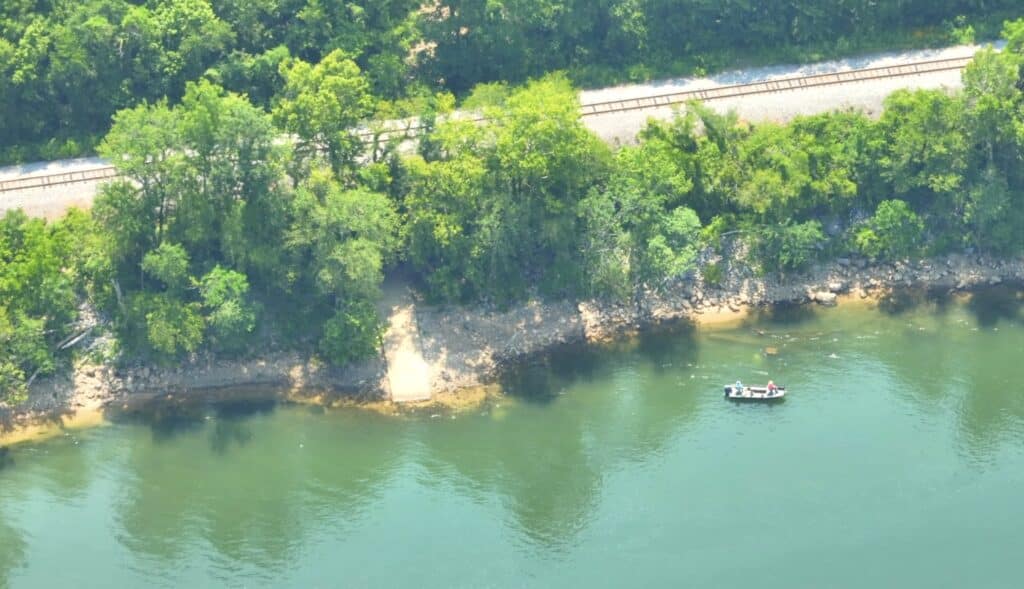
In the aerial photo above we are facing easterly while over the White River. Someone is doing some fishing near the shore and they later told us that the bass were biting that day. If you look at the shoreline (specifically just left of center in the photo) you will see the concrete launch/ramp that extends into the river. Although the train trestle/tunnel is hidden by the leaves on those big trees, you can pretty much see how the road/concrete launch goes under the train tracks, and you can also see a little bit of the gravel road on the other side.
The very first time that we visited the property we looked at the boat ramp (above) and it seemed like the water level in the river may have been a little too low to properly launch anything but a small boat. We have visited the boat ramp several times since our first visit, and generally the water level has been higher than on our first visit. We have not yet brought a boat along with us to really test out the concrete launch, but we hope to do that in the near future!
In the video below, we check out the concrete ramp/launch which is just a few hundred feet west of “The Tracts at White River”:
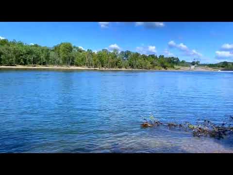
Ground Video of Boat Launch/Ramp next to "The Tracts at White River" – ID#WZ – InstantAcres.com
UPDATE: We have just uncovered some very cool information about this access point to the White River. We already knew how rare it was to have a direct river access point in this area, because traditionally the railroads almost NEVER give approval for an access point which goes under the train tracks. In fact, we have never once heard of the railroads giving approval for a recreational access point that goes under the tracks (they simply are not that concerned about whether or not you get to go fishing).
But, our recent research uncovered several very old maps that showed this access point to the river, and it exists today because it was once a Ferry Crossing across the river! It was called “Walls Ferry” and it existed prior to the train tracks being installed. Although the Ferry may have also gone up and down river, its main purpose was to simply go back and forth across the river, transporting people, animals and goods from one side to the other.
Our best guess is that since it was already a known Ferry Crossing prior to the tracks being laid, the railroads were not able to deny access to the river in that location. The Ferry Crossing would have been too important for commerce and for locals. In fact, the Ferry Crossing would also have been important for the railroad as it would likely have been how farmers and miners on the west side of the river were able to get their goods to the east side, in order to have the goods loaded onto the train for transport.
It seems like the more research we do about this area, the more amazing things we discover!
Next, we have a longer video (drone video) that gives you a better look at “The Tracts at White River”, as well as the river itself and the general area. This video is almost 20 minutes in length, so you won’t offend us if you skip ahead when watching the video!
Drone Video of "The Tracts at White River" showing land, river, boat ramp, etc. – OWNER FINANCING!!
All of the properties at “The Tracts at White River” are accessed via a minimum and/or no maintenance road system, and a four wheel drive truck or suv is required in order to access the properties. Although we have generally not needed to use the four wheel drive in our trucks when we have visited the tracts, there has been at least one time (after it had just rained) when we did use four wheel drive because if we had not we could have possibly damaged the roads by spinning our rear wheels.
The roads and trails throughout these tracts have generally been in existence for many decades with most of them dating back to the 1800’s.
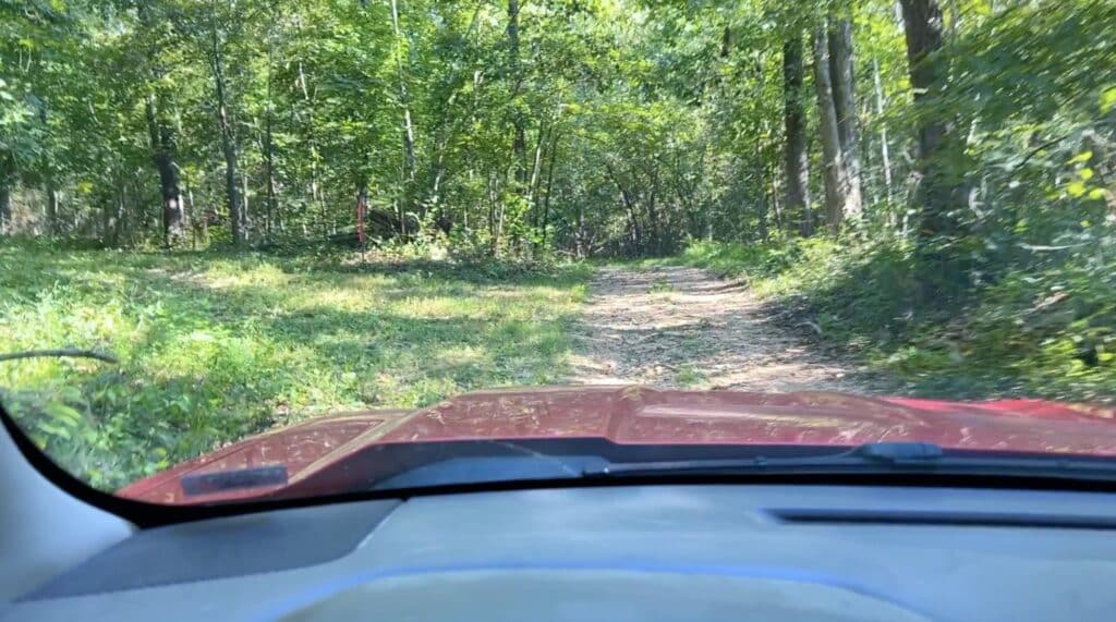
In the photo above, we are parked on one of the easement roads/trails within “The Tracts at White River”. Please Note that in order to purchase a tract within “The Tracts at White River” you must use a four wheel drive truck or suv to access your property. The roads within the area range from Minimum Maintenance roads to No Maintenance roads (this includes Lock 3 Road which we are told is a County Road).
Not only does a four wheel drive provide more traction, but in general a four wheel drive vehicle will have several additional inches of clearance then a two wheel drive vehicle has. Sometimes the extra clearance is more important than extra traction, sometimes the traction is more important then the clearance and sometimes (as we all know) you need the extra traction AND clearance if road conditions are particularly bad.
Are these tracts in the Flood Zone?
The short answer is: “No, the vast majority of these tracts are not in the mapped Flood Zone for the White River.” And the small number of tracts that do have a portion of Flood Zone on them appear to only have the Flood Zone in the area(s) adjacent to or in a creek bed (where you would not be building anyway).
Even though these tracts are VERY close to the famous White River, because of the way the land is situated they have almost no Flood Zone on them. If you are curious about why this is, or if you are curious about “Flood Zones” in general then you can click on the link below which will take you to a page we created that shows the “Flood Zone” map for these tracts and goes into much greater detail about river properties and flood zones. We originally had all of that information within this listing page but we decided to put it on its own page because there is a ton of information and at some point this Main Page would have gotten too cluttered.
Location & Directions
“The Tracts at White River” are in an excellent location in the northern Arkansas Ozarks. They are very private yet you are only about 15 miles from Batesville, Arkansas and only a few hours from numerous major cities.
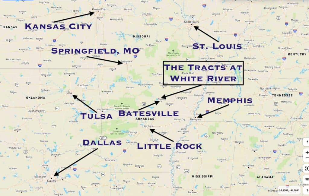
On the map above you can see the location of “The Tracts at White River” (in the middle of the map, close to Batesville, Arkansas). Because of this centralized location, these tracts are within just a few hours of numerous major cities including: Little Rock, AR (1 1/2 hours); Memphis, TN (2 hours); Springfield, MO (3 hours); Mountain Home, AR (1 1/2 hours); St. Louis, MO (4 hours); as well as many others.
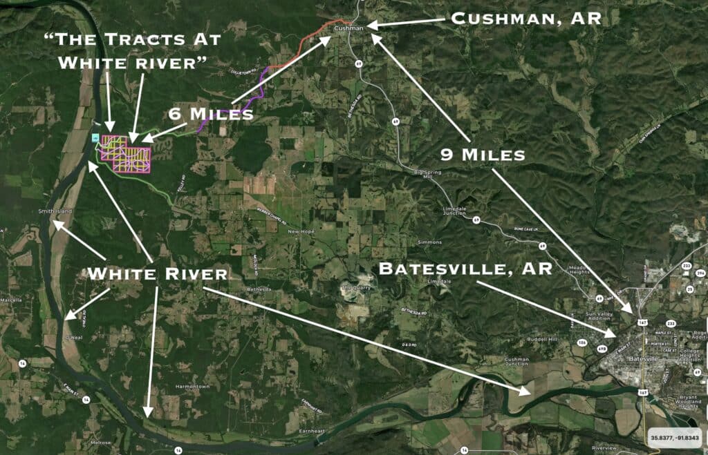
The map above shows the location of “The Tracts at White River”, relative to Batesville, Arkansas. From Batesville, go north on Highway 69 for about 9 miles to the tiny town of Cushman and then go west (see the map below for a more detailed look at the route from Cushman to the property).
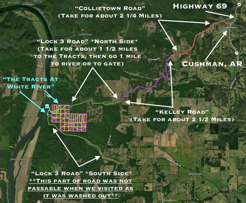
The map above shows how to get to “The Tracts at White River” from Cushman. From Highway 69 in Cushman, go west onto “Collietown Road”. Stay on Collietown Road for about 2 1/4 miles and then go left onto “Kelley Road”. Stay on Kelley Road for about 2 1/2 miles and then go right (west) onto “Lock 3 Road”, which is a gravel road.
When we last drove to the property, the sign was missing for “Lock 3 Road” where you turn off of Kelley Road. But, if you are looking for the road it will be easy to spot it. Once you are heading west on Lock 3 Road you will need to go about 1 1/2 miles before you get to the east side of “The Tracts at White River” (you will come in at the east side of Tract 6). As you continue to the west you will still be on “Lock 3 Road” but you will notice that the road no longer appears to be graded by the County. After you go about another mile on Lock 3 Road you will come to a small field with a power line overhead. This is the power line that runs from the dam toward Batesville to deliver the power that the dam is producing (when it is producing power).
Just after passing through the small field and beneath the power line you should come to a fork in the road. If you veer right at the fork it will lead you to the concrete ramp on the White River (which is now very close to where you are). If you veer left at the fork you will go up a hill and arrive at the “gate” which leads to Tracts 7-36, which you will see on the left side (east side) of the road once you are at the top of the hill.
If you go left after the field/power line and then go up the hill and PAST the “gate” then you will soon start going back down a hill and you are likely to encounter some very bad spots in the road (we sure did). Then, after we had finally made it through those rough spots in the road, we encountered a spot where the road had been washed out, and there was simply no way to cross over the washed out area. If you refer again to the map above (or to the map below), you will see that we have labeled the “impassable” portion of the road that we just talked about. It is the “South Side” of Lock 3 Road. After encountering that bad portion of road on the South Side of Lock 3 Road we decided to stick with just coming in (and also leaving) by using the “North Route”, which is the route described above.
It is possible that the south portion of Lock 3 Road has been repaired and it may now be usable, but we don’t know because we have not found any good reason to use this section of road as it seems like it would take a little longer than the route that we described above (which is the route that we have now used numerous times).
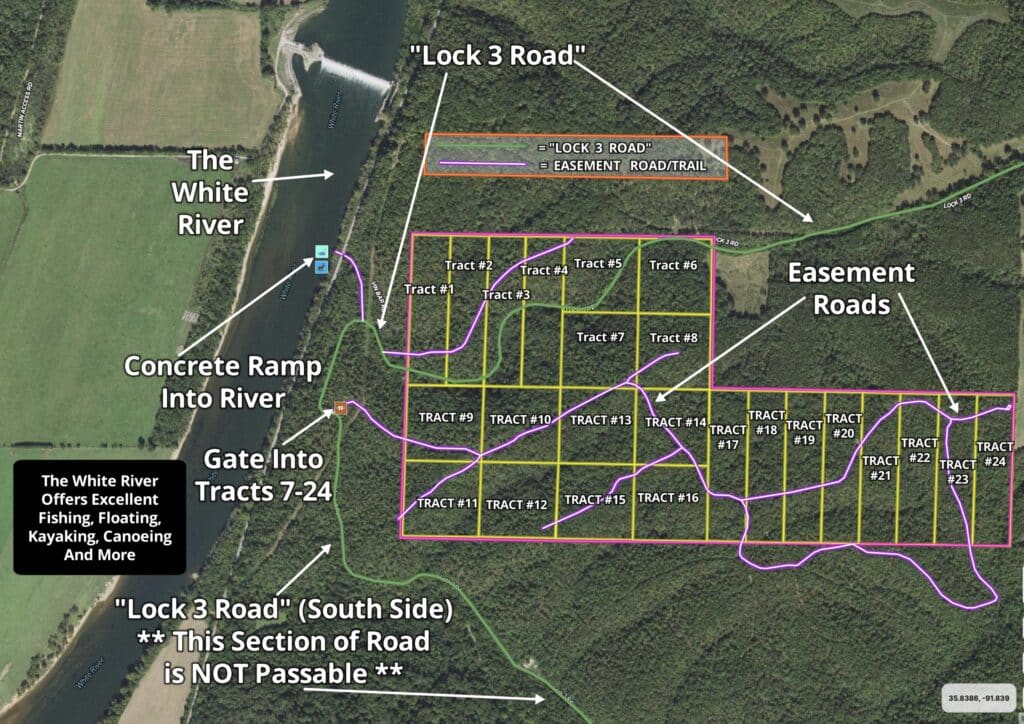
On the map above, “Lock 3 Road” is shown as the “greenish” line. Toward the left side of the map, we have labeled where the gate can be found which leads into most of the tracts. After you go through the gate and head east, the first tract you come to will be Tract 9. When we visit the property, we come in on “Lock 3 Road” from the north (which is also the way that we leave). Although the maps may show that you can come and go using the south part of “Lock 3 Road”, we were not able to use that section of road because we encountered at least one area where the road was simply not passable because it was washed out.
Please be sure to print out the maps and directions before making the trip to check out “The Tracts at White River”. That way, if you encounter an area where you do not have strong cell phone coverage you will still be able to locate the property. We would be happy to email the directions and maps to you, if you would like.
Below, we have a video which shows the drive into “The Tracts at White River”, starting at the little town of Cushman and continuing until we are almost to the gate and the river. It’s a long video, but it does a fairly good job of showing the route to the property:
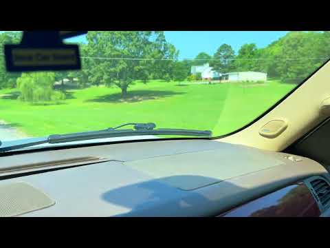
The drive to "The Tracts at White River", starting in Cushman, AR – InstantAcres.com Inc.
If you find it to be easier, you can input the address below into your G.P.S. or navigation unit/phone in order to help on your first trip to the property. Please note that this is NOT the exact address for the property, but when we tested it out it did show up as an address just a few feet east of the property, on “Lock 3 Road”:
770 Lock 3 Road
Batesville, AR 72501
This address should take you to the beginning of the tracts on the east side of “The Tracts at White River” (which would be where the County Road enters the east side of Tract 6). This is also where the road begins to get very rough, as the County has only been maintaining the County Road up to this last address because the rest of the road has very, very little traffic.
In the video below we actually input the address above into Google to see what happens:
Video with 770 Lock 3 Road Address Video ID#WZ
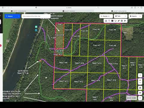
Interactive Map (known as “Land Id” map or “MapRight” map)
Below, we have an interactive map showing the tracts within “The Tracts at White River” as well as the surrounding area:
The Interactive Map above gives you a good look at “The Tracts at White River” as well as the general area and the route to the property. You can zoom in and out and move the map around to see exactly what you want to see. You can also change the “base layer” to see a topo map as well as other base maps.
The Interactive Map can actually be VERY useful when viewing a property (especially on your first trip). If you download the “Land Id” app to your phone then you will be able to view the map on your phone AND it will show your location as a colored dot within the map. This is fantastic when you are locating a property and also if you want to see the approximate boundaries of a property. After you download the app there are a couple of things that you will need to do in order to use it correctly. We have added a video to the top of the “F.A.Q.” page on our website, which explains in more detail how to set up the app so that it is all set for your trip to the property.
The link below will take you to the video on our “F.A.Q.” page which shows how to set up the Land Id/MapRight app. The program we use has been called MapRight for several years and they recently changed the name to Land Id. We use the names interchangeably but really it is now just called Land Id. The app is free but you may have to sign up for a free trial in order to use it properly. Land Id seems to change their procedures fairly often but generally you can at least view a map within their app without any type of subscription (but you may need an account in order to see your location while viewing a map). Here’s the link to our video which explains how to use Land Id/MapRight:
Click Here to see the Video about Land Id which can also be found on our “F.A.Q.” Page
The Interactive Map shows all of the tracts within “The Tracts at White River”, as well as their approximate boundaries, which can be very useful if you are looking for a specific tract when you make it out to the property. We generally consider the Interactive Map program to be fairly accurate, but it does not replace a survey. If you would like to know the precise boundaries of one tract (or multiple tracts) then you would need to contact a surveyor in the area who could give you a quote.
You will likely need to zoom in and out in order to properly view the map, because the labels within the interactive map do not seem to automatically resize themselves which tends to mean that they are often “in the way” as you are viewing the map.
All of the tracts within “The Tracts at White River” are heavily wooded and you can expect to find red oak, white oak, chestnut, pine, hickory and walnut trees, depending upon which tract you choose (as well as many other species).
Power is within about 1/2 a mile of the development but it is not within the development. Options for solar power are good here and solar systems have improved vastly over the last few years (both in quality and in cost).
Links to Information about the Batesville area and the White River:
https://batesvillearea.com
https://theroyalonmain.com
If you know of a good website that has information about this part of the White River or about the Batesville area please let us know. We would love to add more high-quality web pages to the links above.
This is investment-quality acreage in a fantastic location. It has taken us many years to finally locate property next to the actual White River and we are thrilled to be able to make it available to our buyers. Set up your campsite on your private acreage and a short walk (or a very short four wheeler ride) and you are at the river for fishing, swimming and canoeing.
Also, if you decide you would like to “scout out” additional land for hunting and recreation you are just a few miles from several hundred thousand acres of Public Land in the Ozark National Forest. You may even decide to set up your actual “deer camp” on your private acreage and then spend some time hunting within the National Forest and coming back to your private acreage in the afternoons or evenings.
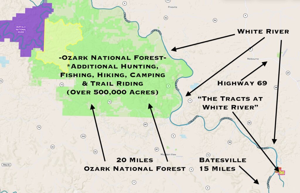
As shown on the map above, “The Tracts at White River” are only a few miles from the enormous Ozark National Forest which gives you a lifetime supply of additional land to explore and enjoy. The 500,000+ acres within the Ozark National Forest can also be used for hunting, fishing, camping, horseback riding and much more.
As we all know, it is getting harder and harder to find good-quality acreage for hunting, fishing and recreation (and building a home or cabin). With their excellent mixture of timber, privacy and location, we think that these tracts represent an incredible investment. Camp, hunt, fish and enjoy your property while the values continue to grow.
Many of these tracts already have more than enough mature timber to build a log cabin (or a timber frame home). After your property has been paid for in full you will be free to use the timber on your property in any manner you see fit (including harvesting it, using it for a home/cabin or just letting it continue to grow).
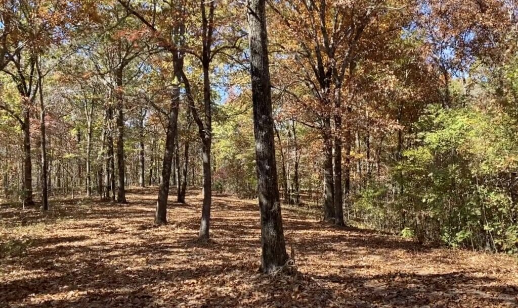
The camping, hunting and recreational opportunities in this area are awesome. The Autumn photo above was taken near about the middle of “The Tracts at White River” and shows a few mature hardwood trees that have lost most of their leaves for the year.
These tracts seem to have the perfect mixture of timber for creating gorgeous Autumn colors. The photo above was actually taken a couple of weeks after the “peak” of the Autumn colors, but we were able to capture a little bit of that special feeling in the photo! The photo above was taken near the east side of the development and we are looking northwest toward the river.
What can you do on your new property at “The Tracts at White River”?
These tracts are NOT subject to the zoning regulations that you will find in most areas of the country! This property is within a Rural Development and does have basic property covenants BUT almost all of the Outcast Land buyers find that these covenants simply do NOT limit what they plan to do with their property. In fact, most Outcast Land buyers that we speak to would simply NOT buy a property without basic covenants in place to protect their investment.
On your property at “The Tracts at White River” you can:
- Hunt (most buyers will buy a tract with deer and turkey hunting in mind)
- Camp
- Build a cabin or a home (subject to property covenants)
- Have a portable building or shipping container (for camping, hunting, recreation and storage)
- Use your camper or RV for camping, hunting and recreation
On your property at “The Tracts at White River” you can not:
- No commercial businesses
- Can not live on the property until the loan has been paid in full
- No cutting of the timber until the property has been paid for in full (we can often make written exceptions for clearing a building site or driveway/trail)
- No junkyards of any kind
All of the tracts at “The Tracts at White River” have setback distances from the easement road and county road. These setback areas are also designated future utility easements (although power is not currently within the development). All buildings, homesites, parking areas, storage areas, etc. must be at least 50 feet from the centerline of the easement roads and any county roads (this area acts as a privacy setback as well as a utility easement). A few of the tracts may already have a private driveway and a clearing in place and the clearing is generally beyond the setback distance so that it can be used for camping, parking, building, etc. (you should measure to be sure).
Fences/gates may not be placed within 50 feet of the centerline of the easement roads or county road, as this area is a designated road easement area.
These tracts represent an excellent opportunity for building your own hunting cabin as there are no building permits required in this area! You and your friends/family can build your own cabin without permits or inspections.
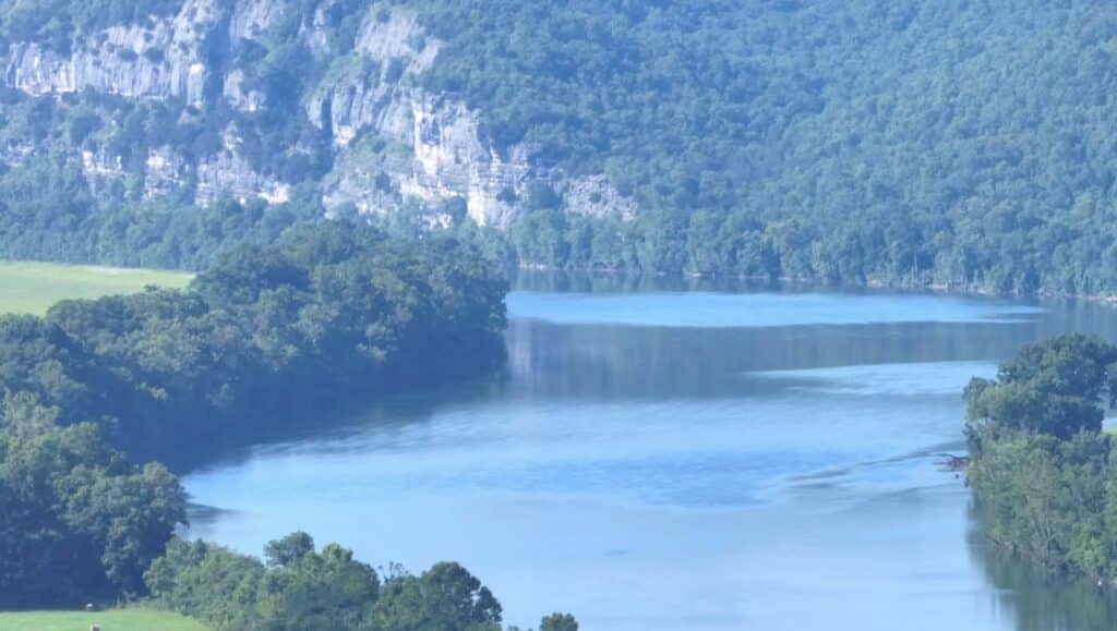
The aerial photo above was taken while facing north over the tracts. We have “zoomed in” on a cool bluff on the river. The White River is well known as one of the premier fishing rivers in the country. People come from all over the U.S. to catch bass, trout, catfish (and more) in this beautiful river. We think these tracts are ideal for fishing, hunting and recreation, and they are VERY private.
It took us many years to be able to bring you acreage at the White River, but we think it was worth the wait! These tracts will sell quickly so if you have been waiting for a special piece of secluded acreage then take a good look at these special properties.
To see an available tract at “The Tracts at White River”, please click on one of the links under the map, toward the top of this page.


