![]()
Very rare acreage in an EXCELLENT area!
Owner Financed land for sale with access into THOUSANDS of acres of Public Land (additional hunting, camping and recreation) and over a mile of the Little Niangua River (for fishing, swimming, kayaking and arrowhead hunting)! These excellent tracts are brought to you by our Sales Partner “Outcast Land Inc.” – Outcast Land Inc. is known for focusing on the highest quality hunting and recreation land in the United States.
Outcast Land is committed to bringing you the HIGHEST QUALITY recreation land in the nation. All tracts are located in areas with a PROVEN track record for deer and turkey hunting. The “Hunting and Recreational Developments” brought to you by Outcast Land have basic Covenants in place to ENSURE that the tract you purchase can be used for hunting and recreation for generations to come. By the way, all tracts sold by Outcast Land are buildable for a cabin or home, subject to the basic property covenants (although most Outcast Land customers are more interested in deer “signs” then street signs).
Although the properties sold by Outcast Land Inc. are buildable for a home or cabin, they can not be used as a residence until after the owner financed loan has been paid in full. Although this does not affect the hunters or recreational users, it could affect folks who are looking for a place to immediately build and live. If you are looking for a place to immediately build and live than please contact us and we can let you know what is available that might suit your needs. This top-quality owner financed land is possibly the perfect place for hunting, camping, recreation and for creating lifelong memories with family and friends.
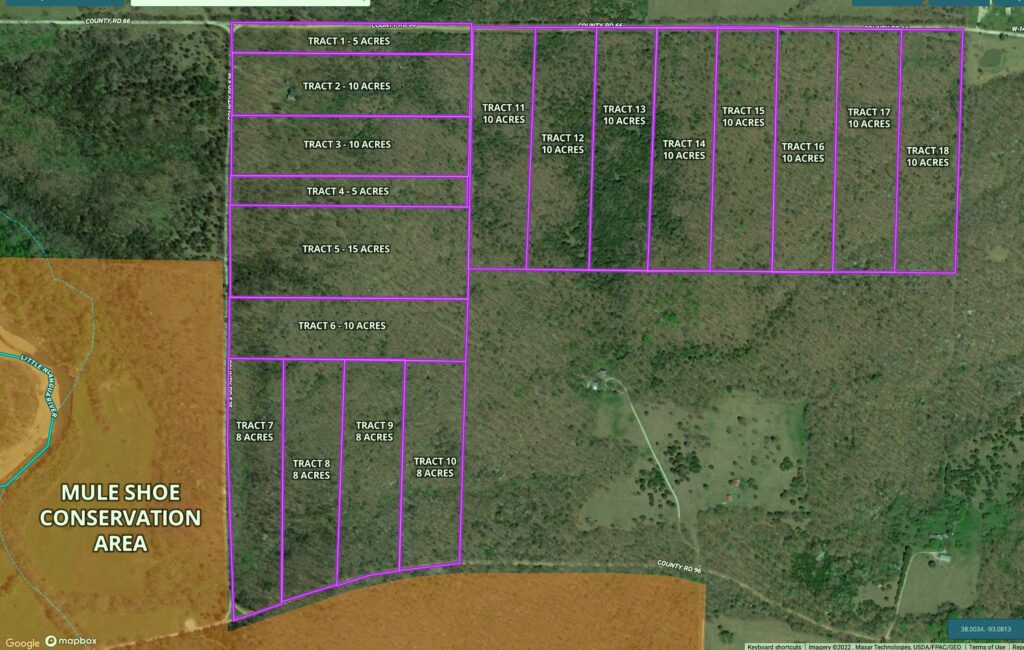
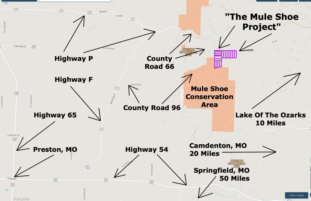
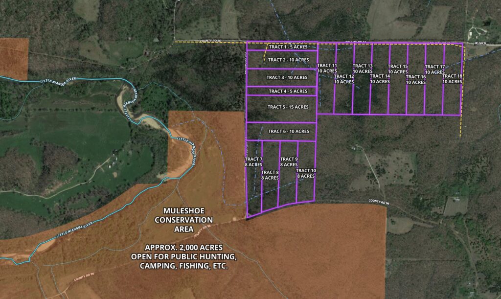
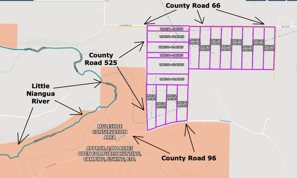
The map below shows the private tracts within “The Mule Shoe Project”. There are a total of 18 tracts, as shown on the map below:
The Mule Shoe Conservation Area is one of the best kept secrets in the Ozarks. This gorgeous area offers opportunities for hunting, camping, fishing, swimming, kayaking, hiking and so much more. Have the Conservation Area as your “backyard” gives you thousands of acres to roam and explore!
Having access to the Mule Shoe Conservation Area gives you an enormous source of additional land for hunting, fishing, camping, trails, swimming, kayaking and recreation. You can have your cabin and/or campsite on your private tract and enjoy thousands of acres of additional land for recreation, right in your own backyard!
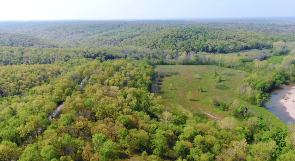
In the aerial photo above we are looking over a part of the Mule Shoe Conservation Area, as well as some of the private tracts. Toward the left you can see the beautiful Little Niangua River which flows directly through the Conservation Area. Toward the right side of the photo (right of center) you can see some of the private tracts, several of which directly border the Conservation Area.
This acreage is in a PROVEN area for deer and turkey hunting. The private tracts are definitely suitable for hunting AND you can generally hunt in the Conservation Area as well, which gives you thousands of acres of additional land to use and enjoy. This section of the Little Niangua River is popular for fishing, including bass and catfish.
Power is directly on several of the tracts, and is within about half a mile (or less) of all tracts. Being outside of city limits means you will not find public water/sewer available (but also means these tracts are not subject to the strict regulations you would find within city limits). If you require a permanent water source you could drill a well or for occasional use a cistern (water collection/storage) can be a good choice. For septic, you can install a standard septic (which can be done yourself) or possibly dig a simple lagoon. For occasional use, an “rv style” toilet works well (as do numerous of other options). We had cell service in the areas we checked within the development (we use Verizon) BUT the service was much better in the higher areas and not in the lower areas. The wireless internet in our work trucks seemed to function fairly well in most areas we tried within the development (again, much better in the higher areas).
All of the tracts within “The Mule Shoe Project” have direct County Road frontage, making it possible for you to access your property throughout the entire year.
Below, you will find a map showing the 18 tracts in “The Mule Shoe Project”, which is located in Hickory County, Missouri. Directly below the map you will see a list showing the available tracts along with their prices/information. Click on the tract number of any available tract (within the list) to see the full information page for that tract.
HUNTERS, CAMPERS AND RECREATIONAL LAND USERS have specific desires and requests when they are searching for their property. In general, these folks plan to camp and use their recreational property more often than most people. They also generally do not plan to build a home and live on the property in the near future.
With these specific needs in mind, Outcast Land is proud to bring you this “Hunting and Recreational Development”. All of these tracts within this rural development are usable for hunting, camping, recreation and even building a home or cabin, but there are a couple of important distinctions that make these tracts special:
- All Outcast Land tracts are buildable but please keep in mind that they can not be used for a permanent residence until after the loan (to us) has been paid for in full. You can definitely build a cabin (or use a portable building) for camping/hunting but in order to live on the property the loan must be paid in full.
- Camping is allowed for up to 90 days a year, instead of the standard 45 days. This gives you twice as much camping/hunting time on your acreage.
- You can ALWAYS camp, for hunting purposes, during the scheduled deer hunting (rifle season) and turkey hunting seasons (even if that would put you over the 90 day period). Outcast Land does NOT wish to limit your hunting opportunities on your property.
Other property covenants (setback distances, etc) will be very similar to the standard Property Covenants that you see within the InstantAcres.com “property covenants” section. To see the Outcast Land Property Covenants please click on the link below:
To see the Outcast Land Property Covenants please click here.
Hunters and Recreational land buyers generally have no interest in living on their property in the near future (although often they do plan for a retirement home/cabin on the property). BUT, many hunters, campers and recreational land buyers do tell us that it can be a hardship to have nearby neighbors living in portable buildings, camper trailers or homemade “tiny homes” while they attempt to enjoy their acreage for hunting & recreation with their friends and families.
We love “homesteaders” and you may also love “homesteaders” but these tracts from Outcast Land are not designed for the “homesteader”. These tracts are designed for the serious hunter/camper/recreational user who does not desire to be surrounded by homesteaders while hunting and using their property.
Please note that timber with a stump diameter larger than 8 inches may not be cut, sold or removed until the property has been paid for in full (we can often give written exceptions for creating a building site or a driveway/trail).
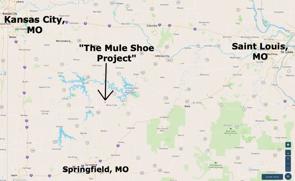
The amazing location of these tracts puts you just a few miles from Camdenton, Missouri, and the world famous Lake Of The Ozarks. In fact, the Little Niangua River (which flows through the Conservation Area) flows northerly for several miles and creates a large portion of the Lake Of The Ozarks.
The map below shows the tracts at The Mule Shoe Project (toward left side of map), as well as the wildly popular Lake Of The Ozarks and Camdenton, Missouri. Camdenton is about 25 miles east of these private tracts.
If you are driving to the property from the Springfield, Missouri area (to the south of these tracts) or from Camdenton, Missouri (to the east of these tracts) then the map below may be helpful for you.
These tracts are certainly a very rare find. Generally, if you are lucky enough to find acreage near a Conservation Area then it is often not close to a regional city. Camdenton, Missouri is just a few miles east of these private tracts.
Now, let’s look at the tracts at The Mule Shoe Project!
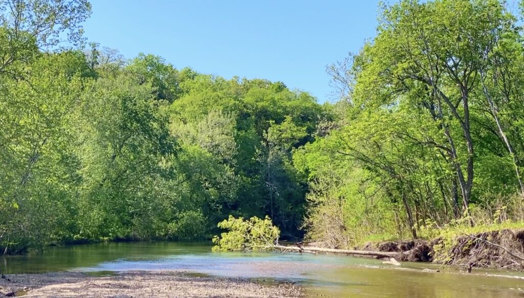
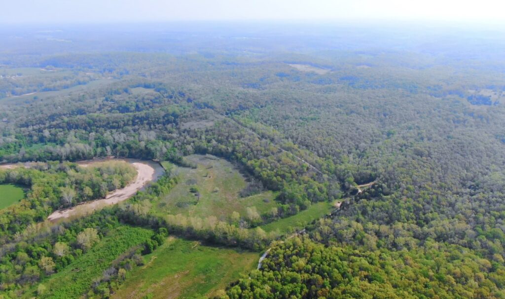
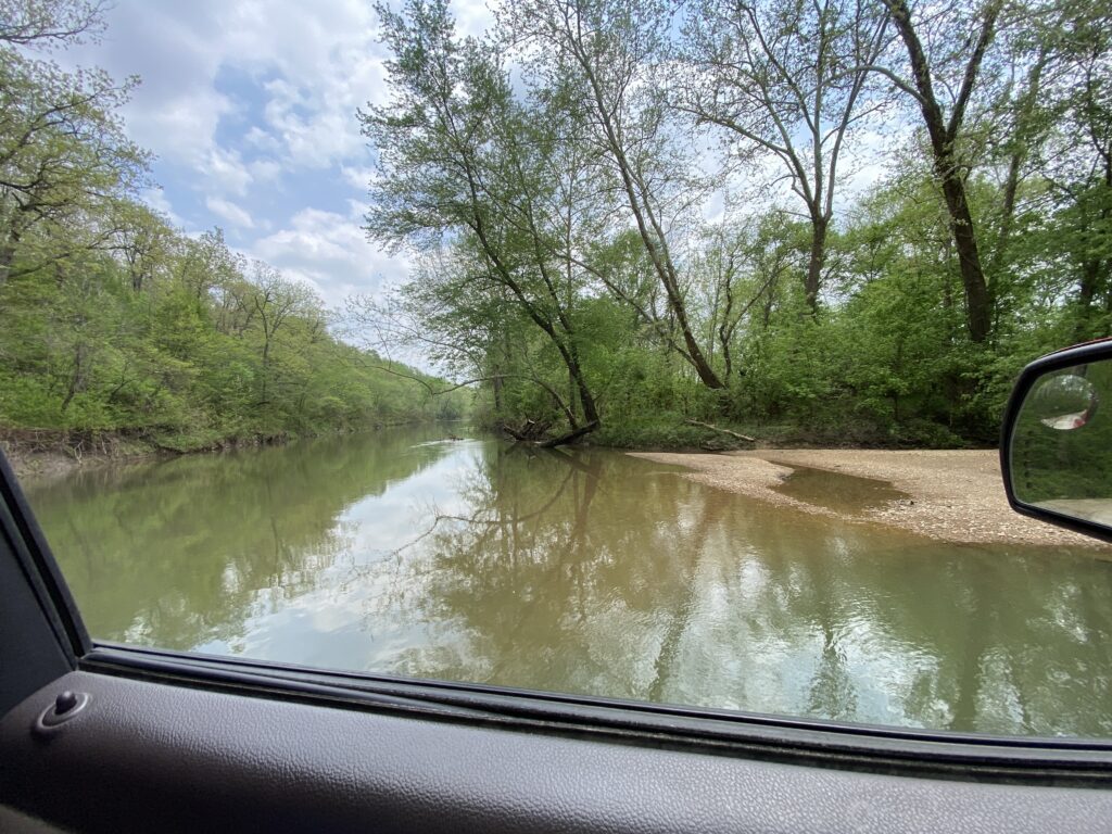
The photo above was taken within the Mule Shoe Conservation Area, on the way to the tracts. We are looking at a section of the Little Niangua River.
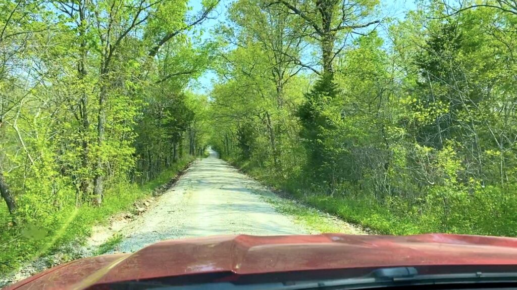
Every one of these private tracts has DIRECT County Road frontage. In the photo above we are parked on the County Road with one of the private tracts on the right (and the Mule Shoe Conservation Area on the left).
In the aerial photo below, we are looking southerly with several of the private tracts on the left and the Mule Shoe Conservation Area (and part of the Little Niangua River) on the right.
The topo map below shows the “lay of the land” in the area. This area is a mixture of highs, lows and everything in between. Although this is the true “Ozarks” which is known for “hills and hollers”, most of the tracts appear to have some type of level area which may be suitable for a level camping or building site. Tracts such as Tract 13, 14, 15 and 16 appear to have a large amount of fairly level area, while tracts such as Tract 7, 8, 9 and 10 do not appear to have very much level area at all and may offer a more challenging situation if you wish to create a large, level site.
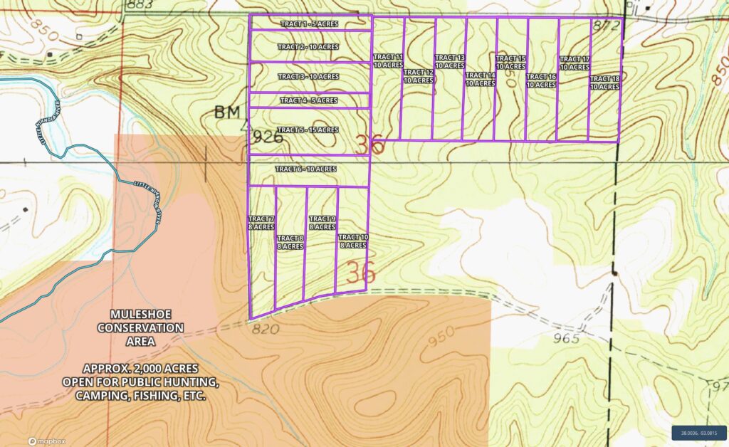
On the aerial map below, we have labeled the approximate location of the power line within the development, as well as a few of the small creeks that we discovered. The power line is shown as the dashed “yellowish” line which cross over the tracts on the north side. There is power directly on Tracts 1, 11, 12, 13, 14, 15, 16, 17 and 18. The power line also runs from Tract 1 onto Tract 2 (as is shown on the map). The little creek beds we discovered are shown as the dashed blue lines. These little creek beds appeared to be flowing when we visited the tracts BUT it had rained about two days earlier which is likely why they were flowing. They are probably all “seasonal” creek beds but they all contain unique rock formations (as many creek beds in the Ozarks do).
VIDEOS!
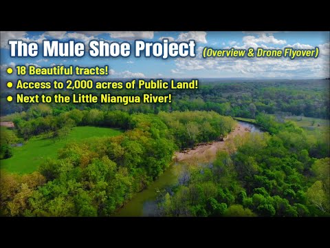
The first video is a “Drone Video” showing the properties and the area, including the Little Niangua River and the Mule Shoe Conservation Area. The video gives you a “Bird’s Eye View” of these special properties and this unique area:
Beautiful Owner Financed Land for Sale in Missouri – The Mule Shoe Project (Links Below)
Next, we have included an “Intro Video” of The Mule Shoe Project as well as the general area. This video is fairly long (over 20 minutes) but it does include quite a bit of good information. In the video, we use the Mapright Interactive Map to explore the area:
Video Intro Muleshoe Conservation Intro May 2022
This next video is one of the longest videos we have ever made (over 30 minutes). In this video, we start from a parking area in the Mule Shoe Conservation Area and we drive the County Roads while we look at all of the tracts within The Mule Shoe Project. Although we don’t explore any of the individual tracts, we do get a good look at all of them from the County Road(s):
Video Ground Mule Shoe Driveby All Tracts WITH MAP Done
The next video is a short one – this is just a fun video that we took while walking around the tracts. The video shows a little creek on one of the tracts. Although we are not positive which tract this video was shot on, we believe it was about where the east side of Tract 3 meets the west side of Tract 11. There appear to be quite a few little “seasonal” creeks on many of the different tracts and this video gives you a quick look at one of them:
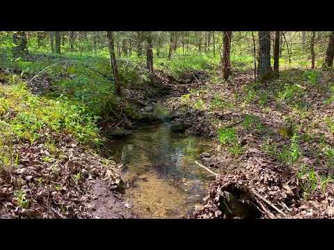
Cool little creek on the north side of the Mule Shoe tracts
This last video was taken at the Little Niangua River, within the Mule Shoe Conservation Area. We crossed this section of the river when we came in to the tracts from the southwest side (taking County Road 96 off of Highway F). There is a bridge over the river and a large gravel bar that you can pull your truck/suv onto, while you explore the river and the Conservation Area. It looked like it would be an EXCELLENT place to search for arrowheads but unfortunately we were short on time when the video was taken. On our next visit we will make sure that we leave extra time for arrowhead hunting! The Little Niangua River runs through the Conservation Area for over a mile, and this video just shows one very small section of the river:
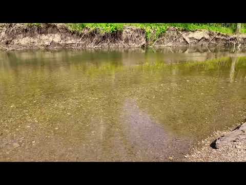
Video Ground Muleshoe at the Little Niangua River DONE
All of the tracts in The Mule Shoe Project are wooded and you can expect to find red oak, white oak, cedar, hickory and even walnut and pecan trees (as well as many other species). All tracts have direct County Road frontage. A few of the tracts have existing driveways, although most tracts would need to have a driveway cleared if you wish to pull your truck onto the property.
Because the Mule Shoe Conservation Area offers free sites for camping, it may be convenient for you to plan to camp in the Conservation Area for a few days while you clear a driveway into your property. Generally, trees with a stump diameter of over 8 inches can not be cut or disturbed until the property has been paid for in full BUT we do recognize that in order to clear a driveway and a site it is almost always necessary to remove some mature timber. Because of this, we have a very simple program in place with which you can generally get written permission to remove the necessary trees (often we are able to give written permission within 1-2 days). Contact us for details about obtaining permission for tree removal for your driveway and building/camping site.
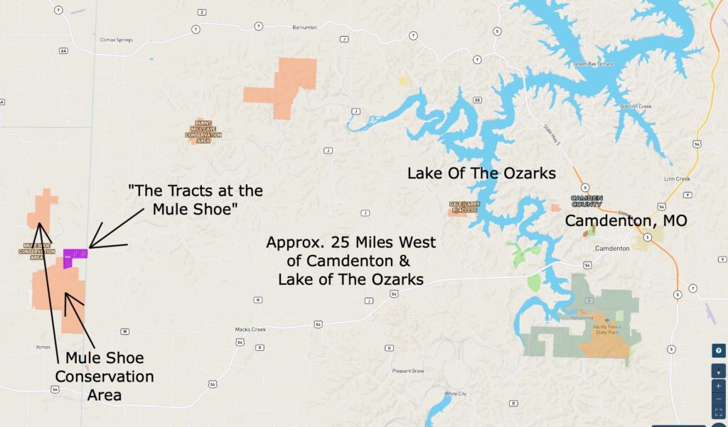
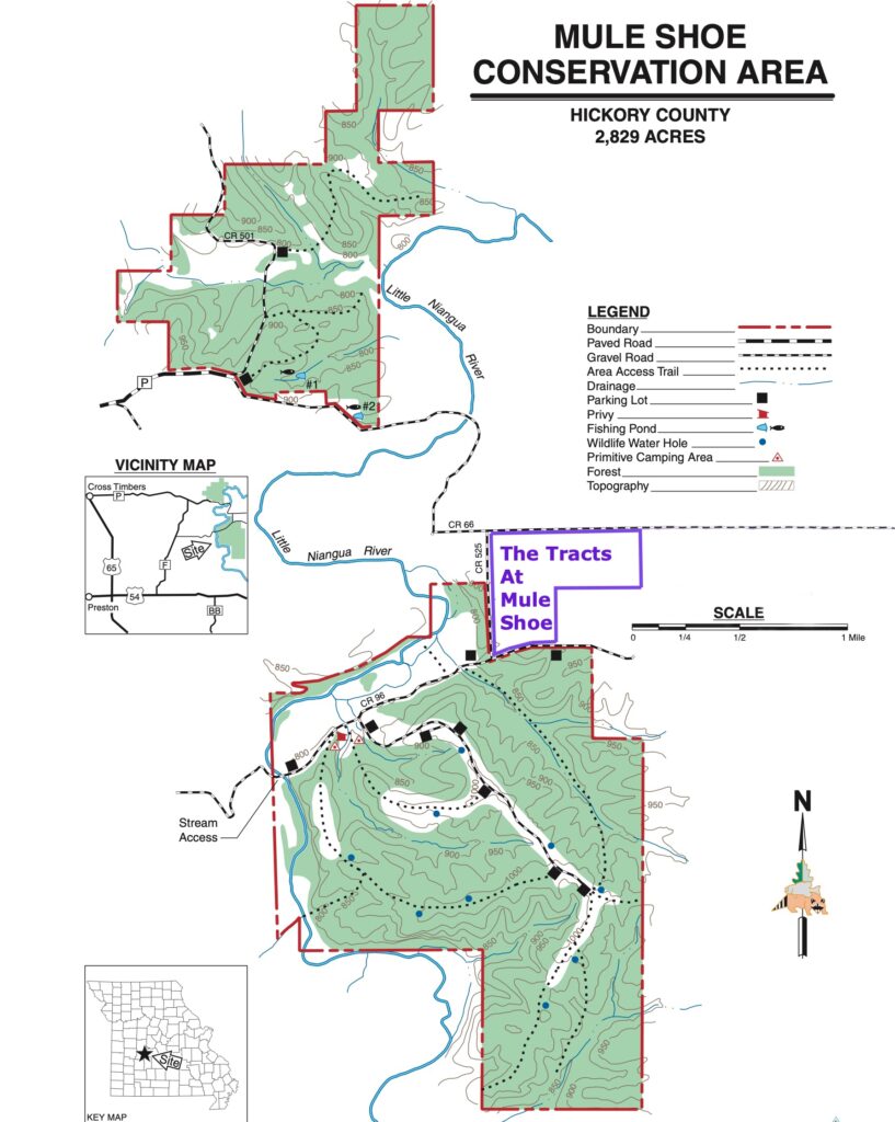
The Conservation Area is located mainly within two large tracts of land (as shown on the map below). We have added the location of “The Mule Shoe Project” to the map by outlining the tracts in purple. The private tracts at “The Mule Shoe Project” are located on the northeast side of the larger section of Conservation Land, which you can see on the map below.
The Conservation Area not only gives you thousands of acres of additional hunting land, it also offers miles of trails, numerous parking areas, campsites and even a public restroom (primitive restroom, but usable). Feel free to explore the trails and watch the deer and turkey hang out in the meadows and by the watering holes in the Conservation Area. In addition to fishing in the Little Niangua River, the Conservation Area has at least two fishing ponds which can be found in the northern section of the Conservation Area.
The map below was created by the Conservation Department and it shows the Mule Shoe Conservation Area (we added “The Tracts at Mule Shoe” to the map). The Conservation Area is a total of 2,829 acres and is located in Hickory County, Missouri.
This is a unique opportunity to own a private tract with excellent access into over 2,000 acres of public land for additional hunting, fishing, camping and recreation.
This is investment-quality acreage in a fantastic location. These heavily wooded tracts are right in the heart of the Ozarks. Close to Camdenton and the Lake Of The Ozarks as well as major rivers, and with excellent access into the Mule Shoe Conservation Area!
As shown on the map above, “The Mule Shoe Project” is in an EXCELLENT location for hunting, camping and recreation. This private rural development is a little over an hour north of Springfield, Missouri which is the largest (and fastest growing) city in southern Missouri.
Below, we have an interactive map showing the tracts within “The Mule Shoe Project” as well as the surrounding area:
The Interactive Map above gives you a good look at “The Mule Shoe Project” as well as at the general area. You can zoom in and out and move the map around to see exactly what you want. You can also change the “base layer” to see a topo map as well as other base maps. The property lines within the map are approximate but should give you a fairly good idea about how these private tracts are situated. The tracts have not been surveyed but there has been survey work done in the area which generally means that a survey could be done at a reasonable cost, if you desire to do so.
These tracts offer maximum privacy as well as being a convenient distance to several towns, creeks, rivers and THOUSANDS of acres of additional Public Land. Several of these private tracts have direct frontage on the Conservation Area. The Mule Shoe Conservation Area can be used for additional, hunting as well as camping, fishing, canoeing, floating and more.
It is getting harder and harder to find good-quality acreage for hunting and recreation (and building a home or cabin). With their privacy and excellent location, these tracts represent what could be an excellent investment. Camp, hunt and enjoy your property while the trees continue to grow and to rise in value.
The camping, hunting and recreational opportunities in this area are awesome. These tracts could be suitable for hunting, camping, building and recreation.
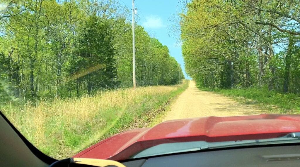
In the photo above we are looking westerly on the County Road which borders the north side of “The Mule Shoe Project” (County Road 66). The tracts are on the left side of the road in this photo. Each tract is unique and offers a different mixture of timber but you can expect to find dozens of different types of trees, flowers and native plant-life.
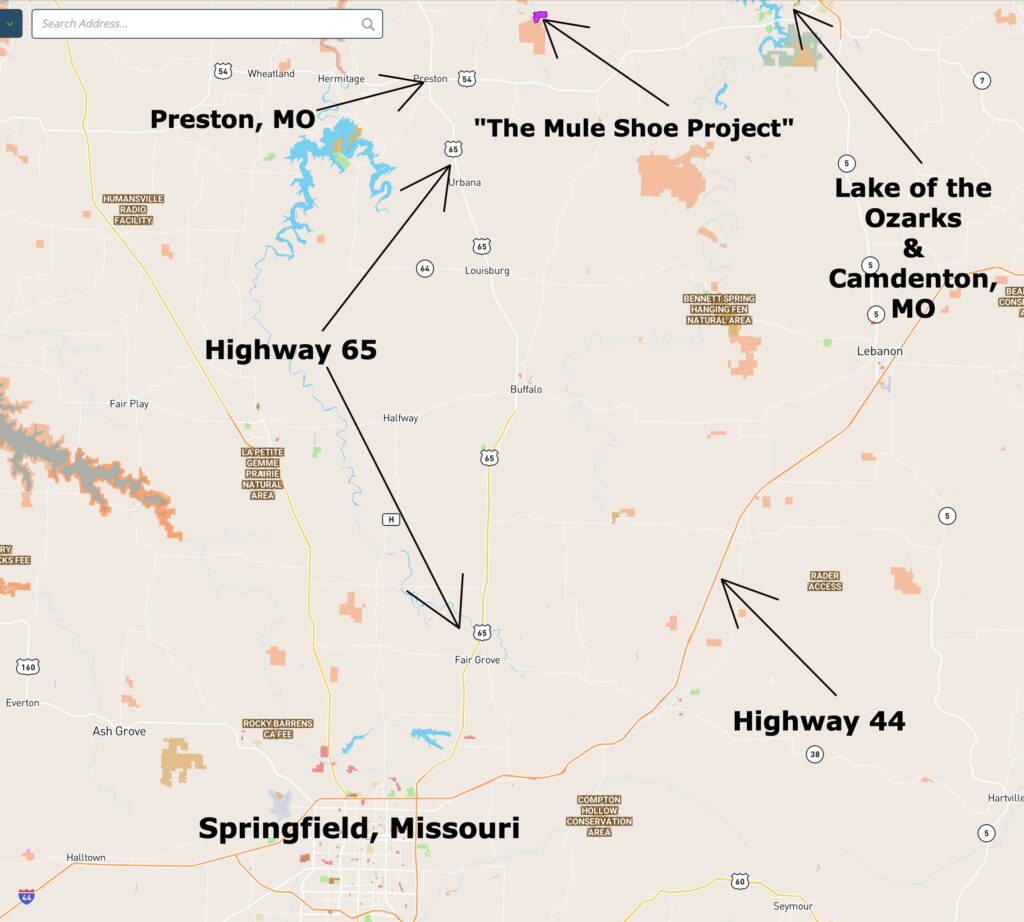
DIRECTIONS from Springfield, MO: To get to “The Mule Shoe Project” from Springfield, just go north on Highway 65 for about 50 miles to the tiny town of Preston and then go east onto Highway 54. Go east on Highway 54 for a little over two miles and then go north onto Highway F. Now go northerly on Highway F for about four miles and then turn right (go east) onto County Road 96, which is a gravel road. Head east on County Road 96 for a little over three miles and you will be at the south side of “The Mule Shoe Project”. If you come in on County Road 96 then the last mile or so of your trip will take you right past the Little Niangua River and through the Conservation Area.
You can also come in from the north by staying on Highway F until it intersects with Highway P. Then go right (east) onto Highway P and continue heading east until it turns into County Road 66 (gravel road). This County Road will take you to the north side of “The Mule Shoe Project”.
Please be sure to print out the maps/directions from this listing page when you visit the property. Additionally, if you watch the video on our “F.A.Q.” page it will explain how you can download the free “MapRight” app which can be very useful for getting to the tracts, as well as exploring the tracts and the area.
The map below shows the tracts relative to Springfield and Camdenton, Missouri:
The next map gives you a closer look at the last couple of miles of the drive to the property:
The map below is similar to the one above, except that it shows a closer view of the area and roads:
Good quality hunting land in the Ozarks has been a proven investment for many years and acreage near Public Land has been popular for generations. As the demand for good property continues to grow, the values will likely continue to rise. Lock in your property now, while you still can!
The map below shows the location of “The Mule Shoe Project” which is well-located within the southern Missouri Ozarks and is just a few hours from several major airports.
On the map above, you can see the location of The Mule Shoe Project as well as some of the nearby cities and towns. Fly into Springfield, MO and you can be on your private acreage in about two hours.
What can you do on your new property at “The Mule Shoe Project”?
These tracts are NOT subject to the zoning regulations that you will find in most areas of the country! This property is within a Rural Development and does have basic property covenants BUT almost all of the Outcast Land buyers find that these covenants simply do NOT limit what they plan to do with their property. In fact, most Outcast Land buyers that we speak to would simply NOT buy a property without basic covenants in place to protect their investment!
On your property at The Mule Shoe Project you can:
- Hunt (most buyers will buy a tract with deer and turkey hunting in mind)
- Camp
- Build a cabin or a home (subject to property covenants)
- Have a portable building or shipping container (for camping, hunting, recreation and storage)
- Use your camper or RV for camping, hunting and recreation
On your property at The Mule Shoe Project you can not:
- No commercial businesses
- Can not live on the property until the owner financed loan has been paid in full
- No cutting of the timber until the property has been paid for in full (we can often make written exceptions for clearing a building site or driveway)
- No junkyards of any kind
All of the tracts at The Mule Shoe Project have setback distances from the County Road for privacy and to maintain the natural “feel” of the area. These setback areas are also designated as potential utility easements. Power is directly on many of the tracts on the north side of the development and having the easements in place makes it a possibility for other buyers to obtain power as well (which would be at buyers’ expense). All buildings, homesites, parking areas, storage areas, etc. must be at least 100 feet from the centerline of the County Road (this area acts as a privacy setback as well as a utility easement).
Fences/gates may not be placed within 50 feet of the centerline of the County Road, as this area is a designated road easement area.
These tracts represent an excellent opportunity for building your own hunting cabin, as there are no building permits required in this area! You and your friends/family can build your own cabin without permits or inspections.
The photo above shows the Little Niangua River at one spot within the Conservation Area. Bring your fishing pole and fish for trout, catfish, sunfish and more.
To see an available tract at The Mule Shoe Project, please click on one of the links under the map, toward the top of this page.


